Batabanó, Cuba facts for kids
Quick facts for kids
Batabanó
|
|
|---|---|
 |
|

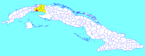
Batabanó municipality (red) within
Mayabeque Province (yellow) and Cuba |
|
| Country | Cuba |
| Province | Mayabeque |
| Founded | 1688 |
| Established | 1898 (Municipality) |
| Area | |
| • Total | 187 km2 (72 sq mi) |
| Elevation | 5 m (16 ft) |
| Population
(2022)
|
|
| • Total | 27,232 |
| • Density | 145.6/km2 (377.2/sq mi) |
| Time zone | UTC-5 (EST) |
| Area code(s) | +53-7 |
| Website | https://www.batabano.gob.cu/es/ |
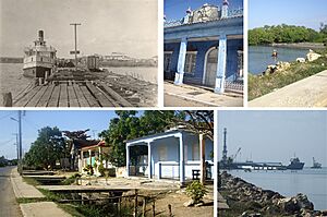
Batabanó is a town and a special area called a municipality in Cuba. It's part of the Mayabeque Province. This town has a long history, as it was founded way back in 1688.
Contents
A Look Back in Time
Batabanó was founded in 1688, making it a very old settlement. For many years, until 1977, the municipality was divided into smaller areas. These areas were known as barrios, and some of them included Pueblo de Batabanó, Surgidero, Camacho, and Pozo Redondo.
Exploring Batabanó's Geography
Batabanó is a place with interesting natural features. Several small rivers flow through the municipality. These include the Río Guanabo, Río San Felipe, and Río San Juan.
Coastal Location and Islands
The municipality is located right next to the Caribbean Sea. This means it has a beautiful coastline. South of the main community, you'll find the Batabanó cays. These are small, low islands that are part of the Canarreos Archipelago.
Neighboring Areas and Villages
Batabanó shares its borders with the Caribbean Sea and several other municipalities. These include Güira de Melena in Artemisa Province, and Quivicán, San José de las Lajas, and Melena del Sur in its own province. The municipality is also home to many small villages, such as 13 de Marzo, Camacho, La Julia, and Surgidero de Batabanó.
Population of Batabanó
In 2022, the municipality of Batabanó had a population of 27,232 people. The total area of Batabanó is about 187 square kilometers (72 square miles). This means that on average, there are about 150 people living in each square kilometer.
Getting Around: Transport in Batabanó
Batabanó has important connections for travel and trade.
Railway and Roads
The town has a railway station that is part of the Havana Suburban Railway network. This line connects Batabanó to Havana and Surgidero. A main state highway, called "Circuito Sur" (CS), also runs through the middle of the town, making it easy to travel by road.
The Important Port of Surgidero
In the village of Surgidero, you'll find a very important marina and port. This port has been active since the 1500s! It used to be the main southern port for Havana, allowing ships to travel to other Cuban cities along the coast before railroads connected the country.
Today, this port is still very busy. It's the main way to get to Isla de la Juventud (Youth Island) and Cayo Largo del Sur by ferry and passenger services. It's also a major port for fishing boats.
See also
 In Spanish: Batabanó para niños
 | Dorothy Vaughan |
 | Charles Henry Turner |
 | Hildrus Poindexter |
 | Henry Cecil McBay |

