Batesville, Virginia facts for kids
Quick facts for kids
Batesville
|
|
|---|---|

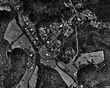
Aerial Photograph of Batesville (1994)
|
|
| Country | United States |
| State | Virginia |
| County | Albemarle |
| Elevation | 620 ft (190 m) |
| Population
(2000)
|
|
| • Total | 59 |
| Time zone | UTC−5 (Eastern (EST)) |
| • Summer (DST) | UTC−4 (EDT) |
| ZIP codes |
22924
|
| Area code(s) | 540 |
| GNIS feature ID | 1492521 |
Batesville is a small community in Albemarle County, Virginia, in the United States. It's not a city or town with its own government, but a group of homes and businesses. It sits about 620 feet (189 meters) above sea level. Long ago, it was also known as Mount Israel or Oliver's Store.
Contents
History of Batesville
How Batesville Began
Batesville started around 1760. It was first called Oliver's Store. This community grew at a spot where two important roads met. By 1829, its name changed to Mount Israel. This is shown in old United States Post Office records. The name Batesville came into use by 1835. It was named after the Bates family who lived there.
Growth and the Turnpike
Batesville's location at a crossroads helped it grow. It became a popular stop for travelers. People could get repairs done there. The community grew even more with the Staunton and James River Turnpike. This special road was approved in 1818. Construction began in 1826.
The turnpike connected farms in the Shenandoah Valley near Staunton. It led to Scottsville on the James River. This road was about 43.5 miles (70 kilometers) long. Batesville was right in the middle of this turnpike.
Farmers used the new road to take their crops to markets in the east. This meant more traffic came through Batesville. Making barrels became a big business there. Repairing stagecoaches was also very important.
Batesville Before the Civil War
By 1835, Batesville had about 70 people living there. Its first post office opened that year. It also served as a place where local elections were held. Batesville kept growing until the American Civil War started in 1861.
Because Batesville was on the turnpike, its economy did not suffer much during the war. The war also did not cause any damage to the buildings in Batesville.
After the Civil War
After the Civil War, the turnpike was given to the county. It started to fall apart because the county focused on bigger towns. The Virginia Central Railroad also came to Albemarle County. It took traffic away from the road through Batesville. Trains were a faster way to move goods.
Even with less traffic, Batesville still grew. This was partly because Albemarle County was doing well. Also, the nearby Miller School was built, which helped the area.
Historic Places in Batesville
Two important places in Batesville are listed on the National Register of Historic Places. These are the Batesville Historic District and Bellevue. These listings help protect their history.
 | Kyle Baker |
 | Joseph Yoakum |
 | Laura Wheeler Waring |
 | Henry Ossawa Tanner |


