Batha (region) facts for kids
Quick facts for kids
Batha
البطحة
|
|
|---|---|

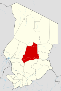
Map of Chad showing Batha.
|
|
| Country | Chad |
| Departments | 3 |
| Sub-prefectures | 10 |
| Regional capital | Ati |
| Population
(2009)
|
|
| • Total | 527,031 |
Batha (Arabic: البطحة) is one of the 23 regions in Chad. It is located right in the middle of the country. This region was once called Batha Prefecture, but its borders were slightly changed. The main city and capital of the Batha region is Ati.
Contents
Exploring Batha's Land
The Batha region shares its borders with several other regions. To the north, it meets Borkou Region. To the east, you'll find Wadi Fira Region and Ouaddaï Region. Sila Region is to the south-east, and Guéra Region is to the south. To the south-west, it borders Hadjer-Lamis Region, and to the west, it touches Bahr el Gazel Region.
Batha's Landscape and Water
The land in Batha is mostly covered in savannah grasslands. These are wide-open areas with tall grasses and scattered trees. As you go further north, the land slowly changes into the Sahara Desert. This northern part of the region has very few people living there. An important lake called Lake Fitri is located in the south-west part of the Batha region.
Main Towns and Cities
Ati is the capital city of the Batha region. Other important towns and settlements in the area include Am Sack, Assinet, Djédaa, Haraze Djombo Kibit, Hidjelidjé, Oum Hadjer, and Yao. These towns are where many people live and work.
People of Batha
In 2009, a census counted the population of the Batha region. There were 527,031 people living there. A little more than half, about 51.9%, were female. On average, a family in a rural area had 5.1 people, while families in urban areas had 5.4 people.
Families and Nomads
There were 103,261 households in total. Most of these, 89,991, were in rural areas. The remaining 13,270 households were in towns. The region also has many nomads, who are people who move from place to place. In 2009, there were 37,419 nomads, making up about 9.6% of the population.
Languages and Groups
Many different groups of people live in Batha, each with their own language and culture. The main groups include Arab people, like the Baggara. They mostly speak Chadian Arabic, which is spoken by about 33.62% of the population. Other groups are the Lisi, including the Bilala (18.11%), and the Naba-Kuka (15.71%). You can also find the Masalit (5.73%) and the Masmaje (5.61%) people here.
Batha's Economy
As of 2015, communicating in Batha was mostly done through the post office. Internet and telephone services were not widely available.
Gold Discovery in Batha
In 2016, something exciting happened: gold was found in the region! This discovery brought many people to Batha. People came from all over Chad, and even from nearby countries like Niger and Sudan. The Chadian army helps manage access to these areas. This ensures that the gold mining is organized and fair.
How Batha is Governed
Chad changed how its government works in February 2003. This process is called decentralisation. It means that power and decisions are shared more locally. Chad was divided into regions, departments, municipalities, and rural communities. The 14 old prefectures were changed into 23 new regions.
Regional Leaders
Each region is managed by a Governor. These Governors are chosen by the President of Chad. The old leaders, called Prefects, still have their titles. They are in charge of smaller areas called departments within each region. People in local assemblies are elected every six years. The leaders who run the government day-to-day are elected every three years. As of 2016, Chad has 23 regions. These regions are set up based on how many people live there and for easier management.
Batha's Departments
The Batha region is divided into three smaller areas called departments. These are:
- Batha Est (East Batha)
- Batha Ouest (West Batha)
- Fitri
See also
 In Spanish: Región de Batha para niños

