
Bathampton Down facts for kids
Quick facts for kids Bathampton Down |
|
|---|---|

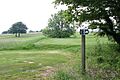
Footpath on Bathampton Down
|
|
| Location | Bathampton, Somerset County, England |
| Area | 15 acres (6.1 ha) |
| Built | Bronze Age – Iron Age |
| Official name: Bathampton Camp | |
| Lua error in Module:Location_map at line 420: attempt to index field 'wikibase' (a nil value). | |
Bathampton Down is a flat, high piece of land in Bathampton, Somerset, England. It sits above the River Avon and the city of Bath. People have lived and worked here for a very long time, since the Stone Age. One important spot is Bathampton Camp, an ancient fort from the Iron Age. This area was also used to dig up stone, and today, part of it is a golf course.
Contents
What is Bathampton Down?
This high land is made of a type of rock called Limestone. This limestone formed a very long time ago, during the Middle Jurassic period. The rock is like a sponge, full of tiny holes. This means there are no streams or rivers on the plateau itself. Many cold springs that used to flow here were moved into reservoirs in the late 1700s and early 1800s.
The southern part of Bathampton Down connects with Claverton Down. This area is special because it's home to many Greater and Lesser Horseshoe bats.

You can find small, old quarries here. People dug for Bath stone in these quarries from Roman times until the 1700s. Some of these old digging sites are now part of the golf course. There was once a tramway that carried stone down to the canal. You can still see parts of it today.
At the highest point, there's a special marker called a Triangulation station. It's about 204 meters (669 feet) above sea level. From here, you get amazing views of the city of Bath and the countryside around it.
The northern slopes of the down have buildings on them. The A36 also runs through this area. To the east, Bathampton Wood separates the plateau from the River Avon and the Kennet and Avon Canal.
A Look Back in Time
People have been active on Bathampton Down for thousands of years.
Ancient Times
The first signs of people here are from the Stone Age. Archaeologists found tools made of flint, like hammerstones and arrowheads.
During the Bronze Age, about 4,000 years ago, people built burial mounds called round barrows. Four of these mounds have been found. Inside one, a small burial pot was discovered. Many of these mounds were explored by John Skinner in the 1700s.

Bathampton Camp is a very old site from the Iron Age. It might have been a hill fort or a place to keep animals safe. It's a large, rectangular area, about 650 meters (2,130 feet) long and 500 meters (1,640 feet) wide. The eastern side didn't need much protection because the ground drops steeply to the River Avon below. On the other three sides, there's a single wall and a ditch.
Archaeologists dug here in the early 1900s and 1950s. They found human and animal bones, along with pottery and flint pieces. This area is now a Scheduled monument, meaning it's protected.
In the Iron Age, the land around the camp was used for farming. There are old field systems, called Celtic fields, that might have been used even into the Roman era. A part of the camp, known as Bushey Norwood, was given to the National Trust in 1960.
Roman Era
There's some evidence of a small Roman house here. However, the area is more known for burials. Two stone coffins from the Roman-British period were found in the late 1700s and early 1800s. Both contained human remains.
Medieval Period
For many years, people thought that some earthworks here were part of the Wansdyke, a large defensive ditch. But now, experts think it's unlikely Wansdyke crossed Bathampton Down.
There's stronger evidence of farming from the Middle Ages. You can still see old farming terraces, called lynchets. There are also several pillow mounds, which were artificial homes for rabbits. These date back to 1256, when King Henry III allowed the Bishop of Bath and Wells to hunt small animals here.
Bathampton Down is also one of the places thought to be the site of the Battle of Badon. This was a famous battle where the legendary King Arthur supposedly won a big victory against the Saxons.
Modern Times

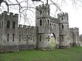
Sham Castle is a strange-looking building on the western edge of Bathampton Down. It was built around 1762 by Richard James for Ralph Allen. It was meant to make the view from Ralph Allen's house in Bath look better. It's a protected building and looks like a castle wall with towers. Sham Castle is lit up at night.
Near the golf course, there's a tall tower for telecommunications.
Around 1730, a new quarry was opened by Ralph Allen to get Bath stone. This stone was used for buildings in Bath. The quarry was used less by the end of the 1700s. But it reopened from about 1800 to 1895 to supply stone for the Kennet and Avon Canal. The stone was lowered down a special gravity tramway to the canal.

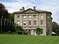
On the southern slopes, you'll find the American Museum in Britain. It's located in Claverton Manor, a large house built in the 1820s. This house is now a Grade I listed building.
A reservoir for drinking water was built on the down in 1955.

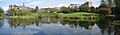
Today, part of Bathampton Down is a golf course, located behind the University of Bath. The university campus started being built in 1964. New buildings were added over the years. The eastern part of the campus has a large "Sports Training Village," built in 1992. The university grounds have won awards for their beauty.
Images for kids
-
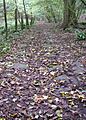
Footpath on Bathampton Down
-
Remains of the tramway
-
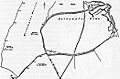
Wansdyke and other earthworks at Bathampton Down
-
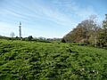
Earthworks with the telecommunications tower in the background
-
Sham Castle
-
The American Museum in Britain at Claverton Manor
-
The University of Bath campus

