Bazoches-sur-Vesles facts for kids
Quick facts for kids
Bazoches-sur-Vesles
|
|
|---|---|
|
Part of Bazoches-et-Saint-Thibaut
|
|

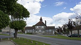
Town hall
|
|
| Country | France |
| Region | Hauts-de-France |
| Department | Aisne |
| Arrondissement | Soissons |
| Canton | Fère-en-Tardenois |
| Commune | Bazoches-et-Saint-Thibaut |
| Area
1
|
9.49 km2 (3.66 sq mi) |
| Population
(2021)
|
439 |
| • Density | 46.26/km2 (119.81/sq mi) |
| Time zone | UTC+01:00 (CET) |
| • Summer (DST) | UTC+02:00 (CEST) |
| Postal code |
02220
|
| Elevation | 52–174 m (171–571 ft) (avg. 58 m or 190 ft) |
| 1 French Land Register data, which excludes lakes, ponds, glaciers > 1 km2 (0.386 sq mi or 247 acres) and river estuaries. | |
Bazoches-sur-Vesles is a small village in northern France. Its name means Bazoches on the Vesle river. Until 2022, it was its own separate village, but now it's part of a new, larger village called Bazoches-et-Saint-Thibaut. It's located in the Aisne area, which is part of the Hauts-de-France region.
Contents
Exploring Bazoches-sur-Vesles: Its Location and Surroundings
Bazoches-sur-Vesles is about 25 kilometers (15 miles) east of Soissons and 30 kilometers (18 miles) west of Rheims. You can easily reach the village using a main road, N31 (also known as E46), which passes just north of it. Another road, D83, connects the village to Mont-Notre-Dame.
The village is also connected by train! There's an SNCF railway line that runs from Paris to Reims, with a station located just south of the village. The eastern edge of Bazoches-sur-Vesles is actually the border between two different areas of France: Aisne and Marne. Most of the land around the village is used for farming, but there are also some small forests.
The Vesle river is an important natural feature here. It forms part of the southern border of the village before flowing through it and then along its western edge. The Vesle river eventually joins another river called the Aisne near Condé-sur-Aisne. You can also find several lakes or reservoirs to the west of the village.
Nearby Villages and Towns
Here are some of the places close to Bazoches-sur-Vesles:
 |
Courcelles-sur-Vesle | Paars | Longueval-Barbonval |  |
| Limé | Fismes | |||
| Mont-Notre-Dame | Chéry-Chartreuve | Saint-Gilles |
A Look Back: The History of Bazoches-sur-Vesles
This area has a long history! Back in the time of the Roman Empire, important Roman leaders in Gaul (which is what France was called then) had a palace here.
Bazoches-sur-Vesles was also a very important place during the First World War. In July and August of 1918, there was a lot of fighting between American and German soldiers in what was known as the Vesle campaign.
Village Leadership: How Bazoches-sur-Vesles Was Governed
Like many villages, Bazoches-sur-Vesles had a mayor who was in charge of local decisions. Here is a list of some of the people who served as mayor:
| From | To | Name |
|---|---|---|
| 2001 | 2008 | Hervé Gironnay |
| 2008 | 2014 | Denis Yvanes |
| 2014 | 2020 | Nicolas Demoury |
| 2020 | 2021 | Christian Drouet |
Population: How Many People Lived Here?
The number of people living in Bazoches-sur-Vesles changed over the years. Here's how the population looked at different times:
| Historical population | ||
|---|---|---|
| Year | Pop. | ±% p.a. |
| 2006 | 440 | — |
| 2011 | 464 | +1.07% |
| 2015 | 465 | +0.05% |
| 2021 | 439 | −0.95% |
| Source: INSEE | ||
Culture and Heritage: Old Buildings and Treasures
Bazoches-sur-Vesles has some very old and important buildings that are protected as historical monuments.
Historical Buildings
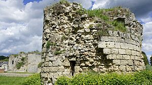
- An old Chateau (castle) from the 13th century. Even though it's mostly ruins now, it's a reminder of the village's past.
The Village Church
The Parish Church of Saint Peter is also very old, dating back to the 12th century. It's registered as a historical monument and holds many valuable items inside, including:
- A special bowl used for baptisms.
- Two old tombstones for Anne de Linanges (from 1560) and Nicolas de Boussu (from 1572).
- A Baptismal font from the 12th century, where people were baptized.
- Old furniture inside the church.
- A Retable (a decorated screen behind the altar) from the 18th century.
- A Chalice (a special cup) from the 19th century.
- A Chasse (a decorated box) for Saint Rufin or Saint Valère from the 19th century.
- A Stoup (a basin for holy water) from the 16th century.
- A painting of a saintly bishop from the 18th century.
- Statues of Sainte-Barbe and the Virgin Mary from the 16th century.
- A statue of the Virgin and child from the 18th century.
- A mosaic artwork showing the Annunciation from the 20th century.
- The main altar's Retable and the sacristy enclosure from the 17th century.
Images for kids
See also
 In Spanish: Bazoches-sur-Vesles para niños
 | Laphonza Butler |
 | Daisy Bates |
 | Elizabeth Piper Ensley |


