Bears Ears facts for kids
Quick facts for kids Bears Ears |
|
|---|---|

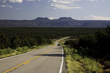
The Bears Ears from Utah State Route 261
|
|
| Highest point | |
| Elevation | 8,481 ft (2,585 m) |
| Prominence | 2,000 feet (610 m) |
| Geography | |
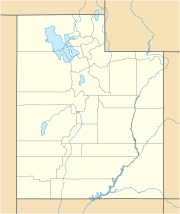
| Location | San Juan County, Utah United States |
| Topo map | USGS Kigalia Point |
The Bears Ears are two tall, flat-topped hills called buttes. They are found in southeastern Utah, United States, in a place called San Juan County. These special buttes are protected as part of the Bears Ears National Monument. This monument is managed by the Bureau of Land Management and the United States Forest Service.
The Bears Ears are surrounded by amazing natural areas. To the west, you'll find the Dark Canyon Wilderness and Beef Basin. To the east is Comb Ridge, and to the north are Indian Creek and Canyonlands National Park. These buttes rise about 2,000 feet (610 meters) above Cedar Mesa to the south. They reach a height of about 8,700 feet (2,652 meters). They are named "Bears Ears" because they look like the ears of a bear peeking up from the horizon.
About the Bears Ears
The Bears Ears are a very important landmark. They are not just cool-looking hills. They are also a sacred place for many Native American tribes. People have lived in this area for thousands of years. They have left behind amazing ancient ruins and rock art.
Why are they called "Bears Ears"?
The name "Bears Ears" comes from how the two buttes look. When you see them from a distance, especially against the horizon, they resemble the ears of a bear. It's like a giant bear is just peeking over the land. This unique shape makes them easy to spot and remember.
Protecting the Bears Ears
The Bears Ears are part of a special protected area. This area is called the Bears Ears National Monument. It was created to protect the natural beauty and the rich history of the land. This includes the ancient sites, plants, and animals. The monument helps make sure these important places are safe for future generations.
 | Leon Lynch |
 | Milton P. Webster |
 | Ferdinand Smith |


