Beaver Run (County Line Branch) facts for kids
Quick facts for kids Beaver Run |
|
|---|---|

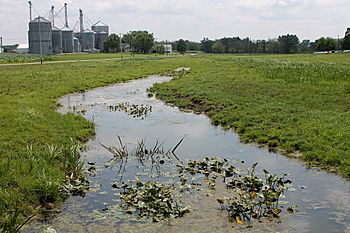
Beaver Run looking downstream near Turbotville
|
|
| Physical characteristics | |
| Main source | eastern Lewis Township, Northumberland County, Pennsylvania |
| River mouth | County Line Branch in Limestone Township, Montour County, Pennsylvania 535 ft (163 m) 41°05′07″N 76°42′33″W / 41.0853°N 76.7091°W |
| Length | 3.9 mi (6.3 km) |
| Basin features | |
| Progression | County Line Branch → West Branch Chillisquaque Creek → Chillisquaque Creek → West Branch Susquehanna River → Susquehanna River → Chesapeake Bay |
Beaver Run is a small stream, also called a tributary, located in Northumberland County and Montour County, in Pennsylvania, United States. It flows into another stream called County Line Branch.
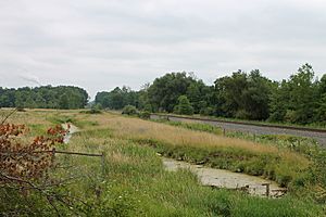
This stream is about 3.9 miles (6.3 km) long. It travels through Lewis Township in Northumberland County and Anthony Township in Montour County. Most of the land around Beaver Run is used for farming. One expert, A. Joseph Armstrong, described Beaver Run as "small and overgrown."
Contents |
Where Does Beaver Run Flow?
Beaver Run starts in the eastern part of Lewis Township, Northumberland County. It first flows southeast for a short distance. Then, it turns southwest and later heads south.
The stream crosses two main roads, Pennsylvania Route 44 and Pennsylvania Route 54. After that, it goes under a Conrail railroad track. It then turns southeast and flows in that direction for a while. It passes by the small community of Schuyler before leaving Lewis Township.
Beaver Run's Journey to County Line Branch
After leaving Lewis Township, Beaver Run enters Limestone Township, Montour County. Here, it turns east for a short distance before turning southeast again.
The stream then crosses another set of railroad tracks. Further downstream, it meets and joins with County Line Branch. This meeting point is near the eastern border of Limestone Township.
How Clean is Beaver Run's Water?
Parts of Beaver Run and the smaller streams that flow into it are affected by pollution. This pollution comes from agriculture, or farming activities. It includes "siltation," which means too much dirt and mud in the water, and "organic enrichment," which means too many nutrients from things like fertilizer.
Because of this pollution, Beaver Run and its smaller streams are listed as "not attaining" clean water goals. This means their water quality is not good enough.
Water Temperature and Oxygen Levels
The water in Beaver Run is relatively warm. This can be a problem for some fish and other water creatures that need cooler water.
Beaver Run also has low levels of dissolved oxygen. Dissolved oxygen is the amount of oxygen gas that is mixed into the water. Fish and other aquatic animals need enough dissolved oxygen to breathe and survive. Low levels can make it hard for them to live in the stream.
What is the Land Around Beaver Run Like?
The area around Beaver Run is part of the Appalachian Mountains. Specifically, it's in a region known for its "ridge and valley" landscape. This means there are long, parallel ridges (hills) and valleys (low areas) in the land.
Rocks and Soil Around the Stream
Most of the land around Beaver Run has certain types of rock underneath it. These include rocks from the Onondaga and Old Port Formation. In the southern part of the area, you'll find rocks from the Keyser and Tonoloway Formation. Higher up the stream, in the northern parts, there are rocks from the Hamilton Group.
The soils in the area also vary. Near the lower parts of the stream, the soil is of the Chenango-Pope-Holly type. The southern parts and middle sections of the stream have Hagerstown-Edom-Washington soil. The upper parts of the stream have Watson-Berks-Alvira soil. There are also "hydric soils," which are soils that are wet for long periods.
Interestingly, Beaver Run is not affected by limestone, which is a common rock type in some other streams. The elevation of Beaver Run near where it joins County Line Branch is about 535 feet (163 m) above sea level.
The Beaver Run Watershed
A "watershed" is all the land area that drains water into a particular stream or river. For Beaver Run, nearly all of its watershed is used for farming. However, there are also some small areas covered by forests.
Besides the townships that Beaver Run flows through, the community of Turbotville is also located within the stream's watershed.
Streams and Bridges
There are a total of 16.85 miles (27.12 km) of streams, including Beaver Run itself and all its smaller tributaries, within the watershed.
A bridge called the Beaver Run Bridge was built over the lower part of Beaver Run in 1915. It's a type of bridge called a closed-spandrel arch bridge. It is 48.9 feet (14.9 m) long and is still open for traffic today.
What Lives in and Around Beaver Run?
As mentioned earlier, Beaver Run has been described as "overgrown." This means there's a lot of plant growth along its banks.
Experts from the Montour County Natural Areas Inventory suggest planting native trees along the stream. Native trees are those that naturally grow in the area. Planting them can help the stream by providing shade, keeping the water cooler, and preventing soil from washing into the stream.
 | Sharif Bey |
 | Hale Woodruff |
 | Richmond Barthé |
 | Purvis Young |


