Beinn Iaruinn facts for kids
Quick facts for kids Beinn Iaruinn |
|
|---|---|

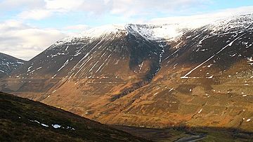
Beinn Iaruinn, showing the natural 'Parallel Roads' feature on its slopes.
|
|
| Highest point | |
| Elevation | 805 m (2,641 ft) |
| Prominence | 466 m (1,529 ft) |
| Listing | Corbett, Marilyn |
| Geography | |
| Location | Highland, Scotland |
| Parent range | Grampian Mountains |
| OS grid | NN297900 |
| Topo map | OS Landranger 34 |
Beinn Iaruinn is a mountain in the beautiful Grampian Mountains of Scotland. It stands tall at 805 meters (about 2,641 feet) and is located northeast of the small village of Spean Bridge. This mountain is special because of a unique natural feature on its slopes, known as the 'Parallel Roads'.
Contents
Discover Beinn Iaruinn
Beinn Iaruinn is a part of the stunning Scottish Highlands. It's one of several mountains called 'Corbetts' that surround a famous valley known as Glen Roy. A Corbett is a Scottish mountain between 2,500 and 3,000 feet high. Beinn Iaruinn is also a 'Marilyn', which is a hill or mountain with a drop of at least 150 meters on all sides.
The mountain offers amazing views of the surrounding landscape. It's a popular spot for hikers who enjoy exploring Scotland's wild nature. The air is fresh, and the scenery is truly breathtaking.
The Mystery of the Parallel Roads
The most famous thing about Beinn Iaruinn is its 'Parallel Roads'. These are not actual roads built by people. Instead, they are natural, flat terraces that run along the sides of the mountain. They look like perfectly straight shelves or tracks.
For a long time, people wondered how these strange lines formed. Some thought they were ancient Roman roads or even giant steps built by mythical creatures! However, scientists have now solved the mystery.
How the Roads Formed
The Parallel Roads of Beinn Iaruinn were formed by ancient Ice Age lakes. Thousands of years ago, during the last Ice Age, huge glaciers covered much of Scotland. These glaciers blocked the valleys, trapping meltwater and forming large lakes.
As the ice melted and retreated, the water levels in these lakes changed. Each time the water level stayed steady for a long period, it created a flat shoreline. Over many years, these shorelines became the distinct terraces we see today. It's like a bathtub ring, but on a massive mountain scale!
The different 'roads' show the different heights of the ancient lakes. You can see three main sets of parallel lines on Beinn Iaruinn. They are a fantastic example of how powerful natural forces can shape our world.
Exploring the Area
Beinn Iaruinn is located in the Highland region of Scotland. This area is famous for its rugged mountains, deep lochs (lakes), and rich history. Many people visit to hike, cycle, and enjoy the outdoors.
The nearby village of Spean Bridge is a good starting point for exploring the region. It's known as the "Commando Memorial" village, honoring the British Commandos who trained there during World War II.
If you visit Beinn Iaruinn, you can walk along some of these ancient 'roads'. It's a unique way to experience a piece of Earth's natural history. Imagine standing where an ancient lake once lapped against the mountainside!
 | John T. Biggers |
 | Thomas Blackshear |
 | Mark Bradford |
 | Beverly Buchanan |


