Belchertown (CDP), Massachusetts facts for kids
Quick facts for kids
Belchertown, Massachusetts
|
|
|---|---|

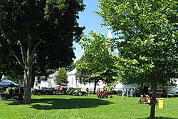
Tractor show on the Common
|
|

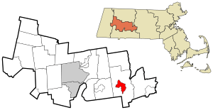
Location in Hampshire County in Massachusetts
|
|
| Country | United States |
| State | Massachusetts |
| County | Hampshire |
| Town | Belchertown |
| Area | |
| • Total | 5.03 sq mi (13.04 km2) |
| • Land | 5.03 sq mi (13.03 km2) |
| • Water | 0.00 sq mi (0.01 km2) |
| Elevation | 607 ft (185 m) |
| Population
(2020)
|
|
| • Total | 3,129 |
| • Density | 621.94/sq mi (240.13/km2) |
| Time zone | UTC-5 (Eastern (EST)) |
| • Summer (DST) | UTC-4 (EDT) |
| ZIP code |
01007
|
| Area code(s) | 413 |
| FIPS code | 25-04790 |
| GNIS feature ID | 0609121 |
Belchertown is a special kind of community called a census-designated place (CDP). It's the main village area within the larger town of Belchertown in Hampshire County, Massachusetts, United States.
In 2020, about 3,129 people lived in the Belchertown CDP. The entire town of Belchertown had a population of 14,649 people in 2010. Belchertown is also part of the larger Springfield Metropolitan Statistical Area.
Contents
Exploring Belchertown's Location
The Belchertown CDP is right in the middle of the town of Belchertown. You can find it at these coordinates: 42°16′42″N 72°24′6″W / 42.27833°N 72.40167°W.
Borders and Boundaries
The CDP has clear boundaries. To the north, it's bordered by Bay Road and Massachusetts Route 9. To the east, you'll find Jabish Brook and Jabish Canal. Broad Brook and Old Springfield Road are to the west. State Street (U.S. Route 202) forms the southern border. Finally, Weston Brook, Lampson Brook, George Hannum Street, and Hamilton Street are also on the western side.
Major Roads and Nearby Cities
Several important roads pass through or near Belchertown:
- Massachusetts Route 9 goes east about 10 miles (16 km) to Ware. It also heads northwest about 9 miles (14 km) to Amherst.
- U.S. Route 202 travels north about 26 miles (42 km) to Athol. It goes southwest about 13 miles (21 km) to Holyoke.
- Massachusetts Route 181 starts in the center of town and goes south about 10 miles (16 km) to Palmer.
- Massachusetts Route 21 leaves U.S. Route 202 on the western side of the CDP. It leads southwest 10 miles (16 km) to Ludlow.
- Springfield, the biggest city in this area, is about 18 miles (29 km) southwest of Belchertown.
Size of the Area
According to the United States Census Bureau, the Belchertown CDP covers a total area of about 5.0 square miles (13.0 square kilometers). Only a tiny part of this area, about 0.04%, is water.
People of Belchertown
| Historical population | |||
|---|---|---|---|
| Census | Pop. | %± | |
| 2020 | 3,129 | — | |
| U.S. Decennial Census | |||
Let's look at who lives in Belchertown. In the year 2000, there were 2,626 people living in the CDP. These people lived in 1,094 households, and 717 of those were families.
Population Details
The population density was about 201 people for every square kilometer (521 people per square mile). There were also 1,111 housing units available.
Most people in the CDP were White (94.14%). Other groups included Black or African American (1.26%), Native American (0.23%), Asian (1.79%), and Pacific Islander (0.04%). Some people identified with other races (0.84%) or with two or more races (1.71%). About 2.13% of the population was Hispanic or Latino.
Households and Families
Out of the 1,094 households, about 37.7% had children under 18 living with them. Nearly 44% were married couples living together. About 18.4% had a female head of the household without a husband present. Also, 34.4% were not families.
About 27.6% of all households had only one person living in them. And 11.1% of households had someone aged 65 or older living alone. On average, there were 2.40 people per household and 2.91 people per family.
Age Groups
The population in the CDP was spread out across different age groups:
- 27.1% were under 18 years old.
- 8.5% were between 18 and 24 years old.
- 33.3% were between 25 and 44 years old.
- 20.5% were between 45 and 64 years old.
- 10.6% were 65 years old or older.
The average age of people in the CDP was 34 years. For every 100 females, there were about 82.6 males.
Income Information
In 2000, the average income for a household in the CDP was $40,250. For families, the average income was $44,286. Men earned an average of $31,377, while women earned an average of $31,130. The average income per person in the CDP was $18,485.
See also
 In Spanish: Belchertown (condado de Hampshire) para niños

