Bellemont, Arizona facts for kids
Quick facts for kids
Camp Navajo
|
|
|---|---|
| Bellemont, Arizona | |
| Country | United States |
| State | Arizona |
| County | Coconino |
| Elevation | 7,166 ft (2,184 m) |
| Time zone | UTC-7 (Mountain (MST)) |
| ZIP code |
86015
|
| Area code(s) | 928 |
| GNIS feature ID | 2805210 |
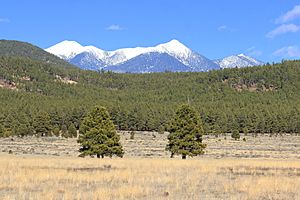
Bellemont is a small community located in Coconino County, Arizona, in the United States. It sits along Interstate 40, about 11 kilometers (or 7 miles) west-northwest of Flagstaff. Bellemont is quite high up, at an elevation of about 7,132 feet (2,174 meters). People say it's the highest community you'll find along the famous historic Route 66! Long ago, it was a popular stop for travelers because of its natural springs, which provided water. In June 2012, about 893 people lived there.
Contents
History of Bellemont
Early Population Figures
In 1940, about 113 people lived in Bellemont. By the 1960 census, the population was around 25.
Tornadoes in 2010
On October 6, 2010, Bellemont experienced a very unusual event: three strong tornadoes hit the area one after another. Tornadoes are powerful spinning columns of air that can cause a lot of damage. These tornadoes were quite strong for Arizona.
The tornadoes damaged 15 homes, making them unsafe to live in. This meant about 30 people had to leave their homes for a while. A train and 30 recreational vehicles (RVs) also got damaged. Luckily, even with all this damage, no one was seriously hurt or died.
Climate in Bellemont
Understanding Bellemont's Weather
Bellemont has a type of weather called a Continental climate. This means it experiences warm, but not extremely hot, summers. The summers are also quite dry. The average monthly temperatures in Bellemont never go above 71.6°F (22°C).
 | Mary Eliza Mahoney |
 | Susie King Taylor |
 | Ida Gray |
 | Eliza Ann Grier |


