Belmont Cragin, Chicago facts for kids
Quick facts for kids
Belmont Cragin
|
|
|---|---|
| Community Area 19 - Belmont Cragin | |

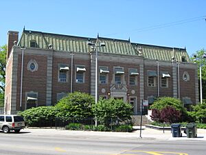
Jacob A. Riis Park Fieldhouse
|
|

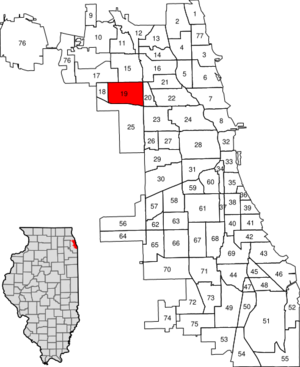
Location within the city of Chicago
|
|
| Country | United States |
| State | Illinois |
| County | Cook |
| City | Chicago |
| Neighborhoods | |
| Area | |
| • Total | 3.94 sq mi (10.20 km2) |
| Population
(2022)
|
|
| • Total | 73,991 |
| • Density | 18,788/sq mi (7,254/km2) |
| Demographics 2018 | |
| • White | 14.6% |
| • Black | 3.5% |
| • Hispanic | 77.8% |
| • Asian | 2.5% |
| • Other | 1.7% |
| Time zone | UTC-6 (CST) |
| • Summer (DST) | UTC-5 (CDT) |
| ZIP Codes |
parts of 60634, 60635, 60639, 60641
|
| Median household income 2022 | $62,476 |
| Source: Chicago Metropolitan Agency for Planning | |
Belmont Cragin is one of the 77 official community areas in Chicago, Illinois. It is located on the Northwest Side of the city. This area is about 8 miles (13 km) northwest of downtown Chicago.
Belmont Cragin is surrounded by other Chicago communities. These include Portage Park, Hermosa, Austin, Montclare, and Dunning.
Contents
History of Belmont Cragin
Early Days
The first business in Belmont Cragin was a saloon. George Merrill opened it around 1835. He settled with his family at Armitage and Grand Avenues. His saloon served farmers who were taking their crops to the city. This spot was known as Whiskey Point.
In 1862, Michael Moran opened a hotel there. But the area stayed mostly rural for many years.
Growth and Industry
Things changed about 20 years later. Cragin Brothers & Company moved their metal processing plant nearby. This plant covered 11 acres (4.5 hectares). The Chicago, Milwaukee & St. Paul Railroad built a station for the workers. This station closed in 2006.
The Cragin company also bought a rivet factory. They moved its machines and workers from Connecticut. More jobs and train service brought many new people to the area. This led to a housing boom. The town was then named Cragin.
Within two years, Cragin had 200 people. It also had a general store, two schools, and a church. The area was originally flat prairie land. Farmers settled here first. Later, people moved from Chicago looking for better living conditions. New factories also drew people in. Belmont-Cragin eventually became part of the City of Chicago.
Factories and New Homes
More railroads brought even more factories and workers. The area became part of Chicago in 1889. This happened when Jefferson Township was annexed. The Belt Railway Company started service here in 1883. New factories opened in Hanson Park and Galewood.
In the same year, Washburn and Moen Manufacturing Company opened a branch. They made wire products. Western Brick and Tile Company also found good clay soil for their business. By 1891, other big companies arrived. These included Westinghouse, Pitts Agricultural Works, and Rice and Bullen Malting Company. They brought even more people to Cragin.
In 1922, W. F. Hall Printing Company built a large plant. It was next to the Northwestern railroad line. This plant helped more factories develop. Workers from Sweden, Germany, and Ireland were among the first to move here. By 1920, jobs also attracted people from Poland and Italy. The population grew very fast. It more than quadrupled in ten years. By 1930, the population reached over 60,000 people. About one-third of them were born in other countries.
In the 1930s, the community became known as Belmont Cragin. Other companies like Zenith (TVs) and Ecco (cookware) also came. Many new homes were built for the workers. Bungalows, Cape Cods, and two-flats were popular housing styles. A neighborhood called Belmont Park was especially popular.
Recent Times
After World War II, until the 1990s, the area was mostly home to people of European descent. These included German, Greek, Irish, Italian, Polish, and Scandinavian families. Many Catholic and Lutheran churches and schools were important to the community.
In the 1920s, a shopping area grew along Belmont Avenue. It was called Belmont Central. Many stores opened there, like Goldblatt's Department Store and Woolworth's. Chicago Transit Authority buses started serving the area in the 1940s. This brought more shoppers.
Brickyard Shopping Center
In March 1977, the Brickyard Shopping Mall opened. It was built on the site of an old brick factory. This mall brought new life to the community. It attracted shoppers from Chicago and the suburbs. The original mall was a large, enclosed building. It was torn down in 2003. New big stores like Target and Lowe's were built instead. This made the area more friendly for cars than for people walking.
Other Local Businesses
Many businesses have been part of Belmont Cragin's history. Central Soya and its silos were located south of Grand Avenue. Revere Copper opened a plant for war materials in 1943. From 1953 to 1963, Western Electric used this building. Glidden paint was also in the area. Cragin Department Store was a family-owned clothing and shoe store. Hawthorn Melody Dairy, Reda's Liquors, and Lizzi's House of Pizza were also local spots. Dominick's grocery store was a well-known place. Now, Tony's grocery store is in that location.
Belmont Cragin's population grew a lot in the 1980s and 1990s. The Hispanic population increased significantly. By the year 2000, about 65 percent of the area's residents were Hispanic. Many Polish immigrants and businesses also came to the area. Residents formed groups like the Northwest Neighborhood Federation. They worked to address community issues.
By 1995, Hall Printing and other factories had closed. The area saw fewer manufacturing jobs and less retail activity. Residents have worked to improve the community and its businesses.
Neighborhoods
The Belmont-Cragin community area includes four main neighborhoods:
- Belmont Central
- Brickyard
- Cragin
- Hanson Park
Education
More people in Belmont Cragin are getting higher education. This is shown in recent reports.
| Level | 2008-2012 Percent | 2018-2022 Percent |
|---|---|---|
| High School Diploma or Equivalent | 31.0 | 30.0 |
| Some College, No Degree | 15.3 | 17.7 |
| Associate’s Degree | 5.7 | 7.1 |
| Bachelor’s Degree | 7.7 | 11.2 |
| Graduate or Professional Degree | 3.0 | 4.9 |
Chicago Public Schools runs the public schools in the area.
Elementary and middle schools serving Belmont Cragin include:
- Acero-Clemente
- Barry
- Belmont-Cragin
- Burbank
- Camras
- CICS-West Belden
- Falconer
- Hanson Park
- ITW
- Lloyd
- Locke
- Northwest Middle
- Prieto
- Schubert
High schools in the area are Steinmetz High School, Prosser Career Academy, and Foreman High School. A small part of Belmont-Cragin is also served by Schurz High School.
The Catholic Archdiocese of Chicago operates many churches and schools. St. Patrick High School is also in the district.
There are two Chicago Public Library branches in Belmont-Cragin:
- The Portage-Cragin Branch opened in 1927. Its permanent building opened in 1969.
- The West Belmont Branch opened in 1971. It is located at 3104 N. Narragansett Ave.
| Historical population | |||
|---|---|---|---|
| Census | Pop. | %± | |
| 1930 | 60,221 | — | |
| 1940 | 63,302 | 5.1% | |
| 1950 | 63,546 | 0.4% | |
| 1960 | 60,883 | −4.2% | |
| 1970 | 57,288 | −5.9% | |
| 1980 | 53,371 | −6.8% | |
| 1990 | 56,787 | 6.4% | |
| 2000 | 78,237 | 37.8% | |
| 2010 | 81,448 | 4.1% | |
| 2020 | 78,116 | −4.1% | |
 | Frances Mary Albrier |
 | Whitney Young |
 | Muhammad Ali |

