Belt Creek (Montana) facts for kids
Quick facts for kids Belt Creek |
|
|---|---|

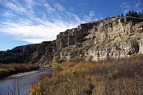
Belt Creek flowing below the cliffs of
Sluice Boxes State Park |
|
|
Mouth of Belt Creek in Montana
|
|
| Native name | kɔyɔ́ɔteihíniicááh |
| Country | Cascade and Chouteau County, Montana |
| Physical characteristics | |
| Main source | 46°50′45″N 110°40′09″W / 46.84583°N 110.66917°W |
| River mouth | 2,792 feet (851 m) 47°35′53″N 111°02′55″W / 47.59806°N 111.04861°W |
| Basin features | |
| River system | Missouri River |
Belt Creek is a river in Montana, United States. It is about 80 miles (129 kilometers) long. This river is a "tributary," which means it flows into a larger river. Belt Creek joins the mighty Missouri River.
The local Atsina people, also known as Gros Ventre, call this river kɔyɔ́ɔteihíniicááh. This name means "belt river."
About Belt Creek
Belt Creek starts in the Lewis and Clark National Forest. This forest is in the Little Belt Mountains in western Judith Basin County. The river begins north of a peak called Big Baldy Mountain.
Its Journey Through Montana
After starting high in the mountains, Belt Creek flows toward the northwest. It carves its way through deep, rocky areas called canyons. One of these is Limestone Canyon.
The river passes by small towns like Monarch. It then flows right through a special place called Sluice Boxes State Park. This park is famous for its narrow canyons and old railroad tracks.
Further along, Belt Creek goes through the towns of Armington and Belt. Finally, it reaches its end point. It joins the Missouri River about 15 miles (25 kilometers) northwest of Great Falls.
How Belt Creek Got Its Name
Belt Creek gets its name from the Little Belt Mountains. These are the mountains where the river begins and flows through. It's like the mountains gave the river its identity!
 | Aaron Henry |
 | T. R. M. Howard |
 | Jesse Jackson |


