Bennington (CDP), New Hampshire facts for kids
Quick facts for kids
Bennington, New Hampshire
|
|
|---|---|

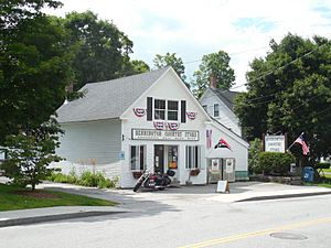
Bennington Country Store
|
|
| Country | United States |
| State | New Hampshire |
| County | Hillsborough |
| Town | Bennington |
| Area | |
| • Total | 0.43 sq mi (1.12 km2) |
| • Land | 0.43 sq mi (1.12 km2) |
| • Water | 0.00 sq mi (0.00 km2) |
| Elevation | 670 ft (200 m) |
| Population
(2020)
|
|
| • Total | 338 |
| • Density | 784.22/sq mi (302.94/km2) |
| Time zone | UTC-5 (Eastern (EST)) |
| • Summer (DST) | UTC-4 (EDT) |
| ZIP code |
03442
|
| Area code(s) | 603 |
| FIPS code | 33-04820 |
| GNIS feature ID | 2629714 |
Bennington is a small community in New Hampshire, United States. It's known as a "census-designated place" (CDP). This means it's a special area defined by the government for counting people. Bennington is the main village within the larger town of Bennington. It is located in Hillsborough County.
In 2020, about 338 people lived in this part of Bennington. The entire town of Bennington had a population of 1,501 people.
Contents
Geography of Bennington
This community is in the western part of the town of Bennington. It sits mostly on the east side of the Contoocook River. Here, the river has "Great Falls," where the water drops about 70 feet (21 meters) over 1.2 miles (1.9 kilometers). This happens after the river flows out of Powder Mill Pond.
The Contoocook River and an old railroad line form the western border of the community. To the north, the border goes past Starrett Road and follows Old Stagecoach Road. The eastern border is just east of the main village area. The southern border follows a small brook back to the Contoocook River.
Roads and Travel
Two main roads, Route 31 and Route 47, go through the center of Bennington.
- Route 31 (Greenfield Road) goes southeast about 5 miles (8 km) to Greenfield.
- Route 47 (Francestown Road) goes east about 7 miles (11 km) to Francestown.
U.S. Route 202 passes just west of Bennington, on the other side of the Contoocook River.
- It goes north about 2 miles (3 km) to Antrim.
- It goes south about 10 miles (16 km) to Peterborough.
Route 31 joins with US 202 to go north to Antrim. Route 47 ends at US 202 just west of Bennington.
The U.S. Census Bureau says that Bennington covers a total area of about 0.43 square miles (1.1 square kilometers). All of this area is land.
People in Bennington
| Historical population | |||
|---|---|---|---|
| Census | Pop. | %± | |
| 2010 | 381 | — | |
| 2020 | 338 | −11.3% | |
| U.S. Decennial Census | |||
In 2010, there were 381 people living in Bennington. There were 140 households, which are groups of people living together. Out of these, 97 were families.
Most people in Bennington were white (about 95.8%). A small number were Asian (1.0%) or from two or more races (1.8%). About 1.8% of the people were Hispanic or Latino.
Households and Families
- About 38.6% of households had children under 18 living with them.
- About 42.9% were married couples living together.
- About 20.0% had a female head of the household with no husband present.
- About 30.7% were not families.
- About 22.1% of all households had only one person living there.
- About 8.6% of households had someone living alone who was 65 years old or older.
The average household had about 2.72 people. The average family had about 3.05 people.
Age Groups
The people in Bennington were of different ages:
- About 28.9% were under 18 years old.
- About 10.8% were between 18 and 24 years old.
- About 25.9% were between 25 and 44 years old.
- About 26.2% were between 45 and 64 years old.
- About 8.1% were 65 years old or older.
The average age of people in Bennington was 32.6 years.
See also
 In Spanish: Bennington (condado de Hillsborough) para niños


