Berrien Township, Michigan facts for kids
Quick facts for kids
Berrien Township, Michigan
|
|
|---|---|

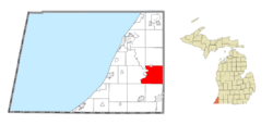
Location within Berrien County (red) and an administered portion of the Eau Claire village (pink)
|
|
| Country | United States |
| State | Michigan |
| County | Berrien |
| Settled | 1827 |
| Established | 1832 |
| Area | |
| • Total | 36.8 sq mi (95.3 km2) |
| • Land | 35.1 sq mi (90.8 km2) |
| • Water | 1.7 sq mi (4.4 km2) |
| Elevation | 787 ft (240 m) |
| Population
(2020)
|
|
| • Total | 4,868 |
| Time zone | UTC-5 (Eastern (EST)) |
| • Summer (DST) | UTC-4 (EDT) |
| ZIP code(s) |
49102, 49103, 49111, 49120
|
| Area code(s) | 269 |
| FIPS code | 26-07820 |
| GNIS feature ID | 1625926 |
Berrien Township is a community located in Berrien County, in the U.S. state of Michigan. It's a type of local government area called a civil township. In 2020, about 4,868 people lived here.
Berrien Township was officially created in 1832. It was named after Berrien County, which it is a part of.
Contents
Exploring Berrien Township Communities
Berrien Township is home to several smaller communities and is close to other towns. Here's a look at some of them:
Berrien Center: A Local Hub
- Berrien Center is a small, unincorporated community within the township. This means it's not a separate town with its own government, but it's a recognized place.
- You can find Berrien Center on M-140. It's about 16 kilometers (10 miles) north of Niles.
- A post office called Berrien Centre first opened here in 1857. Its name changed to Berrien Center in 1893.
- The ZIP code for the Berrien Center post office is 49102. This ZIP code serves the northeastern part of Berrien Township.
Nearby Towns and Their Connections
Several nearby villages and cities also serve parts of Berrien Township:
- The village of Berrien Springs is right next to the township on its western side. The Berrien Springs ZIP code (49103) covers the southwestern part of Berrien Township.
- Part of the village of Eau Claire is inside Berrien Township. The Eau Claire ZIP code (49111) serves the northwestern part of the township.
- The city of Niles is to the south. Its ZIP code (49120) covers the southeastern part of Berrien Township.
- The community of Sodus is to the northwest. Its ZIP code (49126) also serves a small area in the northwest of Berrien Township.
Where is Berrien Township Located?
Berrien Township is in the southeastern part of Berrien County.
- The St. Joseph River forms its western border with Oronoko Charter Township.
- Sodus Township is to the northwest.
- Pipestone Township and Eau Claire are to the north.
- Pokagon Township in Cass County is to the east.
- Niles Township and the city of Niles are to the south.
- Buchanan Township is to the southwest.
Major Roads in Berrien Township
- US 31 crosses the southwestern corner of the township.
- M-140 runs north and south right through the middle of the township.
Berrien Township's Geography
Berrien Township covers a total area of about 95.3 square kilometers (36.8 square miles).
- Most of this area, about 90.8 square kilometers (35.1 square miles), is land.
- The remaining 4.4 square kilometers (1.7 square miles), or about 4.66%, is water.
Who Lives in Berrien Township?
Let's look at some facts about the people living in Berrien Township, based on the 2000 census.
Population and Homes
- In 2000, there were 5,075 people living in the township.
- There were 1,664 households, which are like homes where people live.
- Out of these, 1,331 were families.
- The average household had about 2.82 people, and the average family had about 3.11 people.
Age Groups in the Township
The population of Berrien Township includes people of all ages:
- About 26.9% of the people were under 18 years old.
- About 7.6% were between 18 and 24 years old.
- About 27.8% were between 25 and 44 years old.
- About 24.5% were between 45 and 64 years old.
- About 13.2% were 65 years old or older.
- The median age, which is the middle age of all the people, was 38 years.
See also
 In Spanish: Municipio de Berrien para niños
 | John T. Biggers |
 | Thomas Blackshear |
 | Mark Bradford |
 | Beverly Buchanan |


