Berry Creek, California facts for kids
Quick facts for kids
Berry Creek
|
|
|---|---|

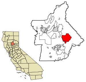
Location of Berry Creek in Butte County, California.
|
|
| Country | |
| State | |
| Butte County | Butte County |
| Area | |
| • Total | 57.18 sq mi (148.09 km2) |
| • Land | 57.12 sq mi (147.94 km2) |
| • Water | 0.06 sq mi (0.15 km2) 0.10% |
| Elevation | 2,000 ft (608 m) |
| Population
(2020)
|
|
| • Total | 1,637 |
| • Density | 28.66/sq mi (11.07/km2) |
| Time zone | UTC-8 (Pacific) |
| • Summer (DST) | UTC-7 (PDT) |
| ZIP code |
95916
|
| Area code | 530 |
| GNIS feature IDs | 1658040, 2612472 |
Berry Creek (once called Berry Valley) is a small community in California. It is a census-designated place, which means it's an area identified by the U.S. Census Bureau for statistical purposes.
This community is about 25 miles (40 km) northeast of Oroville, California. It sits in hilly terrain about 2,000 feet (608 meters) above sea level. Berry Creek is located along the Oroville-Quincy Highway, right on the shore of Madrone Lake.
In Berry Creek, you'll find Berry Creek Elementary School, which teaches students from kindergarten to 8th grade. There are also two small mountain churches, a mini-mart with gas, and a community park. A fun event held every August is the annual Berry Festival!
Berry Creek uses Area code 530 for phone numbers, usually starting with (530) 589-xxxx. Its ZIP code is 95916. This ZIP code is also shared with the nearby community of Brush Creek, California, which is about 4 miles (6.4 km) east. In 2012, the population of Berry Creek was 525 people.
A California Department of Forestry and Fire Protection (CDF) fire station is located in an area called Harts Mill, just south of Berry Creek. Harts Mill was once a historic community, likely a mining town. The CDF Fire Department in Berry Creek is about 2 miles (3.2 km) past the U.S. Post Office on Highway 162.
Two main mountains help define areas in Berry Creek. Bloomer Hill is near the Post Office, and Bald Rock Mountain is where the mini-mart and community park are located. The Berry Festival is always held on Bald Rock Mountain.
Sadly, Berry Creek was largely destroyed by the Bear Fire on September 9, 2020.
Contents
History of Berry Creek
Berry Creek has a long history, including changes to its post office and facing major wildfires.
Early Post Office
The first post office in Berry Creek opened in 1875. It was moved from a place called Oak Arbor, California. Over the years, the post office changed locations several times before closing in 1912. It reopened in 1913, closed again in 1926, and then reopened one more time in 1927.
Wildfires and Their Impact
Berry Creek has been affected by significant wildfires in recent years.
The Camp Fire (2018)
In November 2018, the Camp Fire was a very large wildfire that caused a lot of damage in nearby towns like Paradise and Concow. This fire also threatened Berry Creek. Some wooded areas in Berry Creek were burned, and some buildings were destroyed. Most people living in Berry Creek had to leave their homes for two weeks, from November 10 to November 24.
The Bear Fire (2020)
On the evening of September 9, 2020, the Bear Fire reached Berry Creek. The fire burned almost all the buildings in the town. This tragic event caused widespread destruction in Berry Creek. Sadly, 14 people in the town lost their lives during this fire.
Population Information
| Historical population | |||
|---|---|---|---|
| Census | Pop. | %± | |
| 2020 | 1,637 | — | |
| U.S. Decennial Census | |||
According to the 2010 United States Census, Berry Creek had a population of 525 people in 2012. The population density was about 11 people per square mile (4.2 people per square kilometer).
Most of the people in Berry Creek were White. There were also a few Native American and African American residents. The census showed that all 525 people lived in homes, not in group living situations.
The population was made up of people of all ages. About 12.9% were under 18 years old, and 24.2% were 65 years or older. The average age in Berry Creek was 54.3 years.
There were 515 housing units in the area. Most of these homes were lived in by their owners, while a smaller number were rented.
- This population count includes the communities of Berry Creek, Brush Creek, and Madrone Lake.
See also
 In Spanish: Berry Creek para niños
 | Leon Lynch |
 | Milton P. Webster |
 | Ferdinand Smith |


