
Jacksonville, Alabama facts for kids
Quick facts for kids
Jacksonville, Alabama
|
||
|---|---|---|
|
City
|
||
| City of Jacksonville | ||

Downtown Jacksonville Historic District
|
||
|
||
| Motto(s):
"Education – Commerce – Heritage"
|
||

Location in Calhoun County and Alabama
|
||

Jacksonville, Alabama
Location in the United States
|
||
| Country | United States | |
| State | ||
| County | Calhoun | |
| Founded | July 20, 1833 | |
| Named for | Andrew Jackson | |
| Government | ||
| • Type | Mayor–Council | |
| Area | ||
| • Total | 10.92 sq mi (28.28 km2) | |
| • Land | 10.91 sq mi (28.25 km2) | |
| • Water | 0.01 sq mi (0.03 km2) | |
| Elevation | 709 ft (216 m) | |
| Population
(2020)
|
||
| • Total | 14,385 | |
| • Density | 1,318.76/sq mi (509.19/km2) | |
| Time zone | UTC-6 (Central (CST)) | |
| • Summer (DST) | UTC-5 (CDT) | |
| ZIP code |
36265
|
|
| Area code | 256 | |
| FIPS code | 01-38272 | |
| GNIS feature ID | 0159857 | |

Jacksonville is a city located in Calhoun County, Alabama, in the United States. In 2020, about 14,385 people lived here. This was a big increase from 2010 and 2000.
Jacksonville is part of the Anniston-Oxford Metropolitan Area. The city is also home to Jacksonville State University. This university is a major part of the city's economy and one of the largest employers.
Contents
History of Jacksonville
Jacksonville was started on July 20, 1833. The land was bought from a Creek Indian Chief named "Du-Hoag" Ladiga. At first, the town was called Drayton.
In 1834, the town was renamed to honor President Andrew Jackson. You can find several monuments from the Civil War in town. These include statues of Major John Pelham and a Confederate soldier.
Jacksonville used to be the main city, or county seat, for Calhoun County. Later, the county seat moved to Anniston. Jacksonville State University was founded in the city in 1883.
Tornado Strikes Jacksonville
On March 19, 2018, a strong tornado hit Jacksonville. It caused almost $42 million in damage to the city and the university. Luckily, only four people were hurt.
Many people believe the low number of injuries was because the university was on spring break. More than 1,000 volunteers helped right after the tornado. A student named Caleb Howard said it was "amazing to see the university and the community come together."
Classes at the university started again the next month. Even though many buildings were damaged, graduation happened as planned. The university president, Dr. John Beeler, said it was a happy event. He felt it showed how much they had recovered quickly.
Geography of Jacksonville
Jacksonville is found in the foothills of the Appalachian Mountains. It sits in a valley. To the east is Choccolocco Mountain, and smaller hills are to the west.
The city covers about 25.5 square kilometers (about 10.92 square miles). Only a very small part of this area is water.
Jacksonville's Climate
| Climate data for Jacksonville, Alabama (2004-2022 Precipitation only) | |||||||||||||
|---|---|---|---|---|---|---|---|---|---|---|---|---|---|
| Month | Jan | Feb | Mar | Apr | May | Jun | Jul | Aug | Sep | Oct | Nov | Dec | Year |
| Average precipitation inches (mm) | 4.69 (119) |
5.33 (135) |
5.61 (142) |
4.77 (121) |
4.54 (115) |
4.63 (118) |
4.36 (111) |
4.12 (105) |
3.00 (76) |
3.07 (78) |
3.85 (98) |
5.35 (136) |
53.32 (1,354) |
| Source: NOAA(National Weather Service) | |||||||||||||
Population and People
| Historical population | |||
|---|---|---|---|
| Census | Pop. | %± | |
| 1850 | 716 | — | |
| 1860 | 703 | −1.8% | |
| 1870 | 958 | 36.3% | |
| 1880 | 882 | −7.9% | |
| 1890 | 1,237 | 40.2% | |
| 1900 | 1,176 | −4.9% | |
| 1910 | 2,231 | 89.7% | |
| 1920 | 2,395 | 7.4% | |
| 1930 | 2,840 | 18.6% | |
| 1940 | 2,995 | 5.5% | |
| 1950 | 4,751 | 58.6% | |
| 1960 | 5,678 | 19.5% | |
| 1970 | 7,715 | 35.9% | |
| 1980 | 9,735 | 26.2% | |
| 1990 | 10,283 | 5.6% | |
| 2000 | 8,404 | −18.3% | |
| 2010 | 12,548 | 49.3% | |
| 2020 | 14,385 | 14.6% | |
| U.S. Decennial Census | |||
2020 Census Information
| Race | Num. | Perc. |
|---|---|---|
| White (non-Hispanic) | 7,826 | 54.4% |
| Black or African American (non-Hispanic) | 5,085 | 35.35% |
| Native American | 24 | 0.17% |
| Asian | 334 | 2.32% |
| Pacific Islander | 17 | 0.12% |
| Other/Mixed | 646 | 4.49% |
| Hispanic or Latino | 453 | 3.15% |
In 2020, Jacksonville had 14,385 people living there. There were 4,518 households and 2,472 families.
2010 Census Information
In 2010, the city had 12,548 people. About 68.7% of the people were White, and 26.8% were Black or African American. About 2.3% of the population was Hispanic or Latino.
The average age of people in Jacksonville was about 25.1 years old. This is because many students live in the city due to the university.
Transportation Routes
Two main Alabama state roads go through Jacksonville:
- State Route 21 (Pelham Road)
- State Route 204 (Rudy Abbott Highway)
Education in Jacksonville
Jacksonville is home to Jacksonville State University. This is a public university with almost 10,000 students. It offers many different degrees, like business, education, and nursing. The university campus is just a few blocks north of the town square.
The city also has two public schools:
- Jacksonville High School (for grades 7-12)
- Kitty Stone Elementary School (for grades K-6)
There are also two public schools run by Calhoun County Schools outside the city. These serve nearby communities:
- Pleasant Valley High School
- Pleasant Valley Elementary School
Jacksonville Christian Academy is a private school located in the city. The Calhoun County Center for the Arts also offers classes for the community.
Media Outlets
Newspapers
- The Jacksonville News - A weekly newspaper owned by local people.
- The Chanticleer - A newspaper run by students at Jacksonville State University.
Magazines
- House to House Heart to Heart - A Christian magazine published every two months. It is given out through Churches of Christ.
Television
- WJXS TV 24 - This channel provides local news, sports, and other programs.
Radio Stations
- WCHA Alabama 810 (AM) - Plays classic country music and shares local news and sports.
- WLJS 91.9 (FM) - This is a college radio station that also plays some NPR programs.
Notable People from Jacksonville
Many interesting people have come from Jacksonville, including:
- Rick Bragg, a journalist who won a Pulitzer Prize.
- Glen Browder, who served in the U.S. House of Representatives.
- Riley Green, a country music singer and songwriter.
- Lilly Ledbetter, an activist known for a U.S. Supreme Court case.
- John Pelham, a famous officer from the Civil War.
Images for kids
-
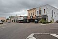
Downtown Jacksonville Historic District
-

Seal of Jacksonville, Alabama
-
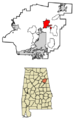
Location in Calhoun County and Alabama
See also
 In Spanish: Jacksonville (Alabama) para niños
