
Biberkopf facts for kids
Quick facts for kids Biberkopf |
|
|---|---|

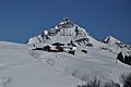
The Biberkopf seen from the northwest, near the Mindelheim Hut
|
|
| Highest point | |
| Elevation | 2599m |
| Prominence | 337 m ↓ Große Steinscharte → Steinschartenkopf |
| Isolation | 3.5 km → Hohes Licht |
| Geography | |
|
Lua error in Module:Location_map at line 420: attempt to index field 'wikibase' (a nil value).
|
|
| Parent range | Central ridge, Allgäu Alps |
| Climbing | |
| First ascent | 1853 during topographical survey |
| Easiest route | Rappensee Hut - marked route (roped in places) - western arête - summit |
The Biberkopf is a tall mountain in the Alps. It sits right on the border between Germany and Austria. This mountain is about 2,599 meters (or 8,527 feet) high. It's a popular spot for hikers and climbers.
Contents
About the Biberkopf
The Biberkopf is part of the main ridge of the Allgäu Alps. This mountain range stretches across parts of Germany and Austria. The Biberkopf marks the border between Bavaria in Germany and Tyrol in Austria.
Where is it located?
The mountain is about 15.5 kilometers (9.6 miles) southwest of a town called Oberstdorf. It's also about 2.5 kilometers (1.6 miles) east of the Schrofen Pass. Some people used to think the Biberkopf was the most southerly point in Bavaria and Germany. However, its peak is actually a bit further north than another spot called the Haldenwanger Eck. That point is about 4,088 meters (2.5 miles) to the west.
What is it made of?
The Biberkopf mountain is mainly made of a type of rock called dolomite. Dolomite is a strong, hard rock that often forms tall, rugged mountains. It gives the Biberkopf its unique shape and look.
First Climbers
The first recorded climb to the top of the Biberkopf happened in 1853. This ascent was part of a survey to map the area. Today, there are marked paths for people to hike up the mountain. One common route starts from the Rappensee Hut and follows the western ridge to the summit. Some parts of this route might even have ropes to help climbers.
Images for kids
-
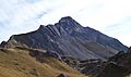
The Biberkopf from the south
-
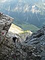
On the way up the mountain
-
From the Saloberkopf to the southwest
-
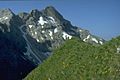
From the Kleiner Rappenkopf to the northeast
-
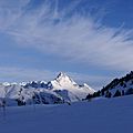
The Walser valley settlement of Bürstegg with the Biberkopf in winter


