Bingara, New South Wales facts for kids
Quick facts for kids BingaraNew South Wales |
|||||||||
|---|---|---|---|---|---|---|---|---|---|

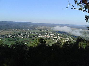
View from HF Batterham Memorial Lookout
|
|||||||||
| Population | 1,428 (2016 census) | ||||||||
| Established | c.1840 | ||||||||
| Postcode(s) | 2404 | ||||||||
| Elevation | 296 m (971 ft) | ||||||||
| Location | |||||||||
| LGA(s) | Gwydir Shire | ||||||||
| County | Murchison | ||||||||
| Federal Division(s) | Parkes | ||||||||
|
|||||||||
Bingara is a cool town in New South Wales, Australia. Its name means 'creek' in the local Aboriginal language. You can find Bingara on the Gwydir River, which is an important part of the Murray-Darling System. Since 2003, Bingara has been the main office for the Gwydir Shire area.
Contents
Where is Bingara Located?
Bingara is in the New England region of New South Wales. It's about 141 kilometers (87 miles) north of Tamworth. It's also 54 kilometers (33 miles) west of Inverell. If you're coming from Sydney, it's 449 kilometers (279 miles) north. From Brisbane, it's 358 kilometers (222 miles) southwest. Bingara is also near Myall Creek, a place with a sad history for Indigenous Australians.
A Look Back: Bingara's History
Long ago, before Europeans arrived, the Bingara area was home to the Wirraayaraay people.
Early Explorers and Settlers
In 1827, a British explorer named Allan Cunningham crossed the Gwydir River near where Bingara is now. He first thought it was a different river, but he soon realized his mistake.
In 1836, the first European settler, Thomas Simpson Hall, arrived. He started a large farm for sheep and cattle. At first, there were conflicts between the local Aboriginal people and Hall's group. Hall even got hurt during one of these fights. A police group was sent to the area, and they had more conflicts with the Aboriginal people. The creek that runs through Bingara is named Hall's Creek after Thomas Simpson Hall.
Gold, Copper, and Diamonds
A big change happened in 1852 when gold was discovered! This brought many people hoping to find riches. Later, in the 1880s, copper and even diamonds were found. Bingara became one of the few places in Australia where diamonds were mined. In fact, it was the biggest diamond producer in Australia at that time!
The town's name was originally Bingera. In 1890, it was officially changed to Bingara. The first post office opened in 1853.
Special Places: Heritage Listings
Bingara has some important historical sites. These places are protected because they tell us about the past.
- 74 Maitland Street: Roxy Theatre and Peters Greek Cafe Complex
- Bingara Delungra Road, Myall Creek: Myall Creek Massacre and Memorial Site
Who Lives in Bingara?
| Historical population | ||
|---|---|---|
| Year | Pop. | ±% |
| 1921 | 1,014 | — |
| 1933 | 1,448 | +42.8% |
| 1947 | — | |
| 1954 | 1,465 | — |
| 1961 | 1,485 | +1.4% |
| 1966 | 1,504 | +1.3% |
| 1971 | 1,401 | −6.8% |
| 1976 | 1,295 | −7.6% |
| 1981 | 1,257 | −2.9% |
| 1986 | 1,363 | +8.4% |
| 1991 | 1,231 | −9.7% |
| 1996 | 1,236 | +0.4% |
| 2001 | 1,172 | −5.2% |
| 2006 | 1,207 | +3.0% |
| 2011 | 1,093 | −9.4% |
| 2016 | 1,074 | −1.7% |
| 2021 | 1,028 | −4.3% |
| Source: Australian Bureau of Statistics data. | ||
In 2016, about 1,428 people lived in Bingara. Most people (82.7%) were born in Australia. Also, 88.2% of people spoke only English at home. The most common religions were Anglican (38.6%), Catholic (16.8%), and No Religion (15.2%).
Bingara is a popular place for older people to live. About 57% of the people are 55 years old or older. The average age in Bingara is 61. The average weekly household income in Bingara is $743. This is lower than the national average of $1,438.
Sports in Bingara
Sports are a big part of life in Bingara!
- The local rugby league team is called the Bingara Bullets.
- The rugby union team is the Gwydir River Rats.
- For cricket, there's the Bingara District Cricket Association. Their main team is the Gwydir First XI.
Some famous sports people from Bingara include:
- Andrew Hart (a former rugby league player)
- David Fordham (a sports broadcaster)
- Adrian Robinson (a jockey from Sydney)
Bingara's Climate
Bingara has a humid subtropical climate. This means it has hot summers and cool winters.
| Climate data for Bingara Post Office, New South Wales, Australia (1878-present normals and extremes); 296 m AMSL | |||||||||||||
|---|---|---|---|---|---|---|---|---|---|---|---|---|---|
| Month | Jan | Feb | Mar | Apr | May | Jun | Jul | Aug | Sep | Oct | Nov | Dec | Year |
| Record high °C (°F) | 40.6 (105.1) |
41.7 (107.1) |
39.4 (102.9) |
35.6 (96.1) |
29.1 (84.4) |
25.0 (77.0) |
25.5 (77.9) |
27.7 (81.9) |
35.0 (95.0) |
39.4 (102.9) |
42.8 (109.0) |
41.7 (107.1) |
42.8 (109.0) |
| Mean daily maximum °C (°F) | 33.6 (92.5) |
32.8 (91.0) |
30.8 (87.4) |
26.7 (80.1) |
22.1 (71.8) |
18.1 (64.6) |
17.7 (63.9) |
19.1 (66.4) |
23.2 (73.8) |
26.9 (80.4) |
30.3 (86.5) |
32.9 (91.2) |
26.2 (79.1) |
| Daily mean °C (°F) | 25.9 (78.6) |
25.1 (77.2) |
22.8 (73.0) |
18.4 (65.1) |
14.2 (57.6) |
10.9 (51.6) |
10.0 (50.0) |
11.3 (52.3) |
14.6 (58.3) |
18.6 (65.5) |
22.0 (71.6) |
24.7 (76.5) |
18.2 (64.8) |
| Mean daily minimum °C (°F) | 18.1 (64.6) |
17.3 (63.1) |
14.8 (58.6) |
10.1 (50.2) |
6.2 (43.2) |
3.7 (38.7) |
2.2 (36.0) |
3.4 (38.1) |
6.0 (42.8) |
10.2 (50.4) |
13.6 (56.5) |
16.5 (61.7) |
10.2 (50.3) |
| Record low °C (°F) | 10.8 (51.4) |
9.2 (48.6) |
6.7 (44.1) |
2.2 (36.0) |
−3.3 (26.1) |
−6.9 (19.6) |
−6.7 (19.9) |
−6.1 (21.0) |
−1.7 (28.9) |
0.0 (32.0) |
3.3 (37.9) |
5.7 (42.3) |
−6.9 (19.6) |
| Average precipitation mm (inches) | 90.9 (3.58) |
86.1 (3.39) |
64.0 (2.52) |
40.5 (1.59) |
48.4 (1.91) |
49.9 (1.96) |
50.4 (1.98) |
43.5 (1.71) |
45.5 (1.79) |
64.8 (2.55) |
71.8 (2.83) |
80.0 (3.15) |
735.8 (28.96) |
| Average precipitation days (≥ 1.0 mm) | 6.1 | 5.5 | 4.9 | 3.4 | 4.0 | 4.7 | 4.8 | 4.4 | 4.5 | 5.6 | 5.9 | 6.4 | 60.2 |
| Source: Australian Bureau of Meteorology (temperature, precipitation- 1878-present normals and extremes) | |||||||||||||
Famous People from Bingara
- Nate Butler
- Andrew Cowper
- John Fordham
 | Aurelia Browder |
 | Nannie Helen Burroughs |
 | Michelle Alexander |


