Binnein an Fhidhleir facts for kids
Quick facts for kids Binnein an Fhidhleir |
|
|---|---|
| (Stob Coire Creagach) | |

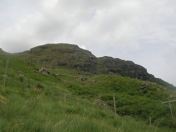
Binnein an Fhidhleir (Stob Coire Creagach top) seen from Butterbridge
|
|
| Highest point | |
| Elevation | 817 m (2,680 ft) |
| Prominence | 504 m (1,654 ft) |
| Parent peak | Beinn Ime |
| Listing | Corbett, Marilyn |
| Naming | |
| English translation | The fiddler's peak (Peak of the rocky corrie) |
| Language of name | Scottish Gaelic |
| Geography | |
| Parent range | Arrochar Alps, Grampian Mountains |
| OS grid | NN230109 |
| Topo map | OS Landranger 56 |
Binnein an Fhidhleir is a mountain in southern Scotland. It is part of a group of mountains called the Arrochar Alps. This mountain stands tall above a place called Butterbridge. It is on the north side of the A83 road.
About Binnein an Fhidhleir
Binnein an Fhidhleir is a well-known mountain in the Arrochar Alps. It is located in Argyll and Bute, Scotland. The mountain faces Beinn an Lochain to the south. It is a popular spot for hikers and climbers.
What's in a Name?
The name Binnein an Fhidhleir comes from Scottish Gaelic. It means "The fiddler's peak." This mountain actually has several different tops. The highest point is called Stob Coire Creagach, which is 817 meters (about 2,680 feet) high. Another top is Creag Bhrosgan, which is 711 meters (about 2,333 feet) tall. Even though Stob Coire Creagach is the highest, the name Binnein an Fhidhleir is often used for the whole mountain.
Binnein an Fhidhleir is listed as both a Marilyn and a Corbett. A Marilyn is a hill in the British Isles that is at least 150 meters (about 492 feet) higher than the land around it. A Corbett is a Scottish mountain between 762 meters (2,500 feet) and 914.4 meters (3,000 feet) high.
Climbing the Mountain
There are a couple of ways to climb Binnein an Fhidhleir. The shortest way starts right above Butterbridge. There is a car park there. This route is quite steep and goes straight up the hillside. You will need to be careful to avoid some small rocky areas.
Another way to climb the mountain is from further up Glen Kinglas. This path follows the mountain's northern ridge. This route is longer than the Butterbridge one. However, it is much less steep, which can make the climb a bit easier.
 | Delilah Pierce |
 | Gordon Parks |
 | Augusta Savage |
 | Charles Ethan Porter |


