Birch Bay, Washington facts for kids
Quick facts for kids
Birch Bay, Washington
|
|
|---|---|

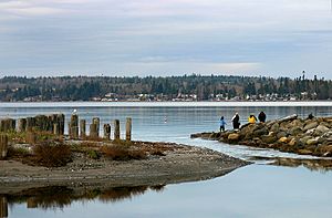
Birch Bay in 2008
|
|

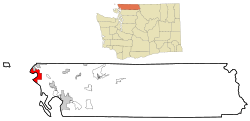
Location of Birch Bay within Whatcom County, Washington
|
|
| Country | United States |
| State | Washington |
| County | Whatcom |
| Area | |
| • Total | 21.2 sq mi (54.9 km2) |
| • Land | 15.8 sq mi (41.0 km2) |
| • Water | 5.4 sq mi (14.0 km2) |
| Elevation | 10 ft (3 m) |
| Population
(2020)
|
|
| • Total | 10,115 |
| • Density | 477.1/sq mi (184.24/km2) |
| Time zone | UTC-8 (Pacific (PST)) |
| • Summer (DST) | UTC-7 (PDT) |
| ZIP code |
98230
|
| Area code | 360 |
| FIPS code | 53-06190 |
| GNIS feature ID | 1512009 |
Birch Bay is a beautiful bay located on the eastern side of the Salish Sea. It's found between Semiahmoo Bay and Lummi Bay. This area is about 100 kilometers (60 miles) north of Seattle. It is also about 35 kilometers (22 miles) south of Vancouver, Canada.
The name "Birch Bay" is also used for a special community along its shore. This community is called a census-designated place (CDP). It is located in Whatcom County, Washington, United States. In 2010, the population was 8,413 people. By 2020, it had grown to 10,115 people.
Local Native American groups had their own names for this place. The Semiahmoo First Nation called it Tsan-wuch. The Lummi Nation (Lhaq'temish) called it Say-wak. Say-wak means "people saved from a flood by building a raft."
Spanish explorers visited this area in 1791 and 1792. Captain Jose Maria Narvaez named it Puerto del Garzon in 1791. Later, in 1792, Archibald Menzies renamed it Birch Bay. He was part of the Vancouver Expedition. Menzies noticed many birch trees around the bay, which is how it got its current name.
Contents
History of Birch Bay
In the 2000s, many new homes and vacation spots were built in Birch Bay. This was because more people from the United States and Canada wanted to live there.
In 2023, there was a plan to make Birch Bay an official city. This idea had been discussed before. By 2020, Birch Bay had grown to about 10,000 people. This made it larger than most other cities in Whatcom County.
Geography of Birch Bay
Birch Bay is in the northwestern part of Whatcom County. It is located on the Salish Sea. The bay is about 6 kilometers (4 miles) south of the border with Canada. It is also about 37 kilometers (23 miles) from Vancouver, British Columbia.
The community around the bay is connected by Washington State Route 548. This is a short highway. It links to Interstate 5 near Ferndale and Blaine.
The total area of the community is about 55 square kilometers (21.2 square miles). Most of this area, about 40.9 square kilometers (15.8 square miles), is land. The rest, about 14.0 square kilometers (5.4 square miles), is water.
How Birch Bay Was Formed
Birch Bay is a type of bay called a "headland bay." It was formed by ocean waves hitting the land on either side of the bay. These land areas are called headlands. Birch Point is the headland to the north. Point Whitehorn is the headland to the south.
When waves enter the bay, they bend and lose energy. This process created the bay's half-moon shape and its gently sloping beach. Over the years, the beach has been changed. Structures like groins and riprap have been added. Groins are walls built out into the water. Riprap is a layer of large rocks. These help protect the shoreline. Terrell Creek also flows along part of the beach and eventually into the bay.
People of Birch Bay
In 2000, there were 4,961 people living in Birch Bay. By 2010, this number grew to 8,413. In 2020, the population reached 10,115 people.
The average age of people in Birch Bay in 2000 was 41 years old. About 23.2% of the population was under 18 years old. About 15.9% of the population was 65 years old or older.
See also
 In Spanish: Birch Bay (Washington) para niños
 | Aaron Henry |
 | T. R. M. Howard |
 | Jesse Jackson |

