
Bixby Creek Bridge facts for kids
Quick facts for kids Bixby Creek Bridge |
|
|---|---|

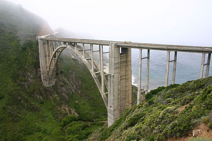
Bixby Creek Bridge from its northern end
|
|
| Coordinates | 36°22′17″N 121°54′07″W / 36.37139°N 121.90194°W |
| Carries | |
| Crosses | Bixby Creek |
| Locale | Big Sur Monterey County |
| Owner | State of California |
| Maintained by | California Department of Transportation |
| Characteristics | |
| Design | reinforced concrete open-spandrel arch bridge |
| Total length | 714 feet (218 m) |
| Width | 24 feet (7 m) |
| Height | 280 feet (85 m) |
| Longest span | 360 feet (110 m) |
| Clearance below | 260 feet (79 m) |
| History | |
| Construction begin | August 24, 1931 |
| Construction end | October 15, 1932 |
| Opened | November 27, 1932 |
| Statistics | |
| Daily traffic | 4,500 |
| Lua error in Module:Location_map at line 420: attempt to index field 'wikibase' (a nil value). | |
The Bixby Creek Bridge, also known as Bixby Canyon Bridge, is a famous bridge on the Big Sur coast in California. It is one of the most photographed bridges in California. People love its beautiful design and amazing location. This bridge is a special type called a reinforced concrete open-spandrel arch bridge.
The bridge is about 120 miles (190 km) south of San Francisco. It is also 13 miles (21 km) south of Carmel. You can find it in Monterey County along State Route 1.
Before the bridge opened in 1932, people in the Big Sur area were often cut off. During winter, the old road was blocked by bad weather. This made it hard to travel. The Bixby Creek Bridge cost $199,861 to build. This was less than planned!
At 360 feet (110 m), it was the longest concrete arch bridge in California. When it was finished, it was the highest single-span arch bridge in the world. It is still one of the tallest today.
The land around the bridge was privately owned for a long time. Later, local people and groups worked to protect these lands. They wanted to stop logging and building. Now, much of the land is owned by government agencies. In 1996, the bridge was made stronger to resist earthquakes. This cost $20 million. Even so, the bridge is still considered "functionally obsolete." This means its 24 feet (7.3 m) width is too narrow for today's standards. New bridges need to be 32 feet (9.8 m) wide.
Contents
Why the Bridge is Special
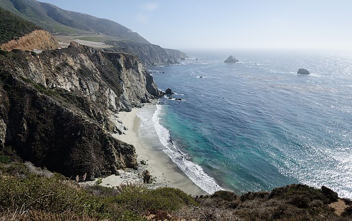
The Bixby Creek Bridge is one of the most photographed places on the West Coast. It appears on postcards, in TV ads, and more. Its location on the beautiful Central Coast of California makes it very special.
The bridge's curved arch and tall columns add to its beauty. It is seen as the "gateway to Big Sur." The land around it is still wild and natural. Many people say it is where the ocean and land meet in the most amazing way in the United States.
Bridge Features
The bridge is 714 feet (218 m) long in total. It is 24 feet (7.3 m) wide. There is 260 feet (79 m) of space below the bridge. The main arch span is 360 feet (110 m) long. This means half of the road sits right above the arch.
The arch ribs are thick. They are five feet thick at the top and nine feet thick at the bottom. These arches are also four and a half feet wide. The bridge was built to be very strong. It can hold more than six times the weight it was designed for.
The two large, vertical supports on each side of the arch look nice. But engineers later learned they were not really needed. Newer bridges like the Frederick W. Panhorst Bridge don't have them. Other nearby bridges, like the Rocky Creek Bridge, are also made of reinforced concrete.
Building the Bridge
California started building Route 56, also called the Carmel–San Simeon Highway, in 1919. Many bridges were needed. The biggest one was the Bixby Creek Bridge.
Choosing the Best Design

State engineers looked at two ways to cross the creek. One idea was an inland route with a smaller bridge. The other was a coastal route with a larger bridge. The inland route would have needed a long tunnel through the Santa Lucia Mountains.
Engineers chose the coastal route. It was safer and offered better views. It also caused less harm to the environment.
Engineers C. H. Purcell and F. W. Panhorst decided between a steel or concrete bridge. A steel bridge would cost more to build and keep up. The salty sea air would make it rust, needing lots of painting. A steel bridge also would not look as natural.
They chose concrete because it cost less. It also looked more like the natural rock cliffs. This choice helped create jobs during the Great Depression.
The state gave the building contract to Ward Engineering Company. They started building on August 24, 1931.
Materials and How it Was Built

Workers used over 300,000 board feet of Douglas fir wood. This wood was used to build a tall temporary structure called a falsework. This falsework was 250 feet (76 m) high. It held up the arch while it was being built. The wood came from Monterey and was brought to the bridge site on a narrow, one-way road.
Building the falsework was hard because of strong winds. It took two months to build it. Sometimes, high waves would threaten the falsework, stopping work.
Crews dug out 4,700 cubic yards (3,600 m3) of earth and rock. Trucks brought in 600,000 pounds of steel to make the bridge stronger. Sand and gravel came from a nearby plant in Big Sur.
The bridge needed 45,000 sacks of cement. This cement came from places like Davenport and San Andreas. Workers started pouring concrete on November 27. The concrete was moved across the canyon using slings from a cable 300 feet (91 m) above the creek.

The bridge was finished on October 15, 1932. The whole highway took five more years to complete. The bridge cost $199,861. It was the longest concrete arch bridge in California at 360 feet (110 m). The road finally opened in 1937 after 18 years of work.
The Rainbow Bridge Name
After it was built, the bridge was sometimes called the Rainbow Bridge. This was because of the Rainbow Lodge resort nearby. The lodge was run by Captain Howard Sharpe and his wife, Frida.
Sharpe had bought land in Bixby Creek Canyon in 1919. He built roads to his lodge. When the bridge was finished, tourists no longer needed to go down to his lodge. So, he built a new lodge on the highway north of the bridge.
Making the Bridge Earthquake Safe
The bridge was made stronger to protect it from earthquakes. This work started in 1996. Engineers had to find a way to make it safe while keeping its historical look. They also had to keep at least one lane of the bridge open during construction.
The main idea was to make the entire bridge deck stronger. This involved adding special steel rods and concrete. The project cost $20 million and finished in November 2000. Even after this work, the bridge is still considered "functionally obsolete" because it is narrower than modern standards.
Bridge History
The land around Bixby Creek was once home to the native Esselen people. They would visit the coast to gather shellfish and fish. Later, the Spanish arrived and established missions.
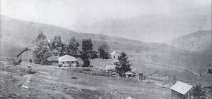
Charles Bixby and Mill Creek
Bixby Creek is named after Charles Henry Bixby. He was a businessman who came to California in 1852. He bought land near Bixby Creek in 1889. He built a sawmill on the creek, which was known as Mill Creek for many years. He cut down trees for lumber and bark.
Bixby also found lime deposits on a ridge above the creek. He built kilns to process the lime. He used mules to carry the lime to the coast. Since he couldn't build a dock, he used a hoist. Barrels of lime were attached to a cable and moved out to ships. The lime was used for cement and other building materials.
Bixby tried to get the county to build a road to Bixby Creek, but they refused. So, in 1870, Bixby and his father hired men to build the first wagon road. It had 23 bridges and went from Carmel Mission to Bixby Creek.
Later, Bixby partnered with William B. Post. They extended the road, which became known as the Old Coast Road. This road went inland to avoid deep canyons and rivers. The 30-mile trip from Carmel could take three days by wagon. The road was often closed in winter.
In 1906, Bixby sold the land to the Monterey Lime Company. They built lime kilns and mined limestone. They also cut down many old redwood trees to fuel the kilns. The kilns operated until 1911 when a flood damaged them.
In recent years, parts of the land once owned by Bixby have been protected. Local groups and government agencies worked to buy the land. This stopped logging and development. In 2020, a large part of the Adler Ranch, which was part of the original Bixby land, was bought. It was then given to the Esselen tribe.
Early Resorts and Businesses

A post office was set up near the sawmill in the 1880s. Later, Captain Howard G. and Frida Sharpe bought the Bixby Creek canyon property in 1919. They rented out cabins to visitors.
When the Bixby Creek Bridge was finished, the old lodge was no longer on the main road. So, in 1931, Sharpe built a new stone Rainbow Lodge on the highway north of the bridge. In 1938, Sharpe found a group of California sea otters. People thought these otters were extinct! More tourists came to see them. Sharpe added more cabins and called it the Bixby Inn.
The restaurant at the lodge closed during World War II. Later, the building was found to be unsafe and was removed in 1953.
Brazil Ranch and Preservation
The Brazil Ranch is on Serra Hill, just south of the Bixby Creek Bridge. This spot is one of the most photographed places in Big Sur. The Brazil family owned this 1,255 acres (508 ha) ranch for almost 100 years.
In 1977, the Brazil family sold the ranch to Allen Funt. He was the creator of the TV show Candid Camera. Funt raised horses and cattle there. After Funt passed away, a land speculator bought the property. He planned to divide the land into many smaller pieces to build on.
Local community leaders and activists were very upset. They worked together to stop the development. The Trust for Public Land bought the property for over $26.25 million. On September 24, 2002, the land was added to the Los Padres National Forest. This helped protect the beautiful area.
Today, visitors can enter this protected land. There is a dirt road south of the bridge. You can hike up a steep trail to see amazing views of the coast.
Roads and Trails
To reach the Mill Creek Redwood Preserve, a 2.7 miles (4.3 km) trail was built. This trail took ten years to build by hand. However, the trail was closed in 2016 because of damage from the Soberanes fire. As of June 2020, the Palo Colorado Road is also closed due to damage from rains after the fire.
Access to the preserve is limited. Visitors need to get a permit in advance. The Old Coast Road, which the bridge replaced, is still open to vehicles when the weather is good. This road is 11 miles (18 km) long from the north side of Bixby Creek.
Scenic Views
The Bixby Creek Bridge makes driving Highway 1 very scenic. The 72 miles (116 km) section of Highway 1 from Cambria to Carmel Highlands was named a Scenic Highway in 1965. In 1966, First Lady Lady Bird Johnson held a ceremony at the bridge to celebrate this.
Popularity and Visitors
The Bixby Creek Bridge was popular even before smartphones and social media. But now, many more people visit the bridge and Big Sur. During holidays and vacations, traffic can be very slow near the bridge.
The bridge was named the top "Instagram-Worthy Destination for 2019 Travels." The California tourism commission calls it a "must-see road trip spot." It is probably the most Instagrammed place along the Highway 1 coast.
Sometimes, the area around the bridge is like a busy parking lot. People often stop on the highway to take pictures. This can make it hard for other cars to pass safely.
Gallery
- Bixby Creek Bridge
-
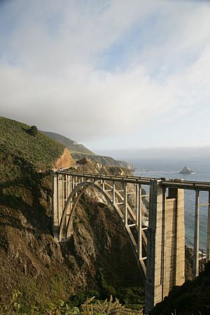
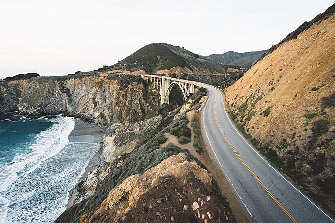
Viewed from the Old Coast Road
-
Afternoon view
-
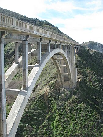
The central spandrel arch
-
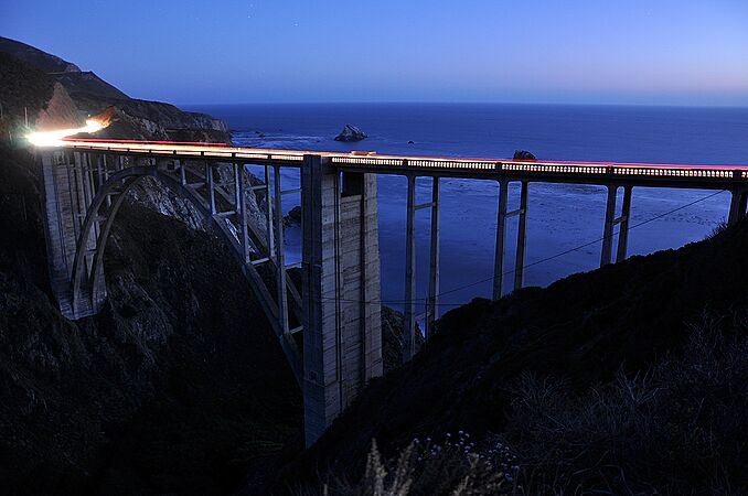
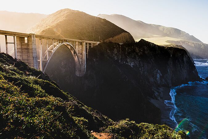
Sunset view
-
Early morning
-
Southern view
-
The northern tower
-
Coastal view
-
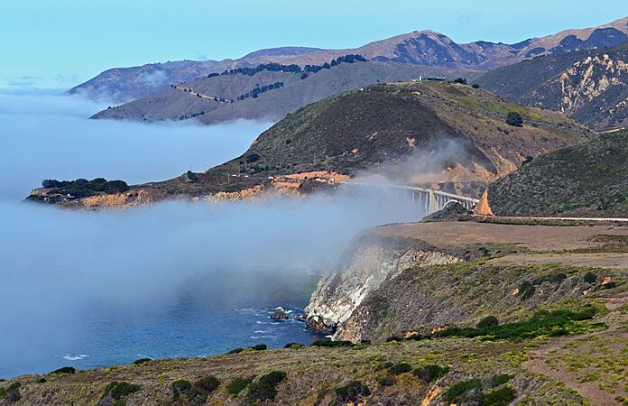
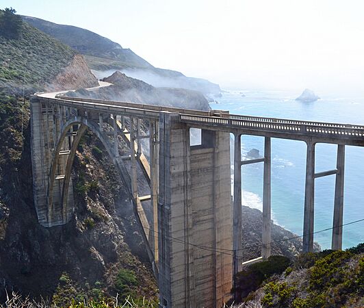
Morning fog

.jpg)
_(1).JPG)

.jpg)
.jpg)
.jpg)

.jpg)
In Popular Media
On a Stamp

The bridge was featured on an express mail stamp. The United States Postal Service released this $18.30 stamp on February 3, 2010. It shows a colorful picture of the Bixby Creek Bridge.
Apple's MacOS Big Sur
The Bixby Creek Bridge is a big part of the main icon for Apple's Big Sur computer operating system. It also shows up in the "Big Sur Day," "Big Sur Night," and "Big Sur Aerial" desktop pictures.
Movies, TV, and Games
The bridge has been in many movies and TV shows. It was in the opening scene of the 1969-70 TV series Then Came Bronson. You can also see it in the films Play Misty for Me, Escape To Witch Mountain, and The Sandpiper. It has been in many car commercials too. The bridge is also in the video game Grand Theft Auto V. More recently, it was in the opening credits of the 2017 TV series Big Little Lies.

