
Black Donald Lake facts for kids
Quick facts for kids Black Donald Lake |
|
|---|---|

Black Donald Lake
Location in Southern Ontario
|
|
| Location | Renfrew County & Frontenac County, Ontario |
| Coordinates | 45°13′01″N 76°56′23″W / 45.21694°N 76.93972°W |
| Type | Reservoir |
| Part of | Saint Lawrence River drainage basin |
| Primary inflows | Madawaska River, Black Donald Creek, Little Black Donald Creek |
| Primary outflows | Madawaska River |
| Basin countries | Canada |
| First flooded | 1966 |
| Max. length | 12 kilometres (7.5 mi) |
| Max. width | 5.5 kilometres (3.4 mi) |
| Surface area | 34.4 square kilometres (13.3 sq mi) |
| Average depth | 45.7 metres (150 ft) |
| Surface elevation | 248 metres (814 ft) |
| Settlements | Black Donald |
Black Donald Lake is a large reservoir in Ontario, Canada. It is located in both Renfrew County and Frontenac County. This lake is part of the Madawaska River system. Its waters eventually flow into the Saint Lawrence River.
The Madawaska River flows into Black Donald Lake from Centennial Lake. Two smaller streams, Black Donald Creek and Little Black Donald Creek, also feed the lake. The Madawaska River also flows out of Black Donald Lake. It goes over the dam at the Mountain Chute Generating Station. This station uses the water to create electricity. The water then travels through the Madawaska River to the Ottawa River, then to the Saint Lawrence River, and finally to the Atlantic Ocean.
Black Donald Lake forms the border between Greater Madawaska (in Renfrew County) and North Frontenac (in Frontenac County). This border runs from the lake's outflow almost to where the Madawaska River enters.
Contents
How Black Donald Lake Was Made
Black Donald Lake is a man-made lake, also known as a reservoir. It was created between 1965 and 1966. This happened when the Mountain Chute Generating Station and its dam were built. Another smaller dam was also constructed nearby.
Before the dam, there was a natural lake called White Fish Lake. Black Donald Lake grew to cover White Fish Lake. It also flooded an old mining town called Black Donald Mines. This town had a graphite mine, but it was no longer in use. The reservoir took about six months to fill up. It covered a large area of land, about 8,500 acres.
Today, people mostly use Black Donald Lake for fun activities. It is popular for recreation, tourism, and for people who own cottages nearby.
The Lost Town of Black Donald
There used to be a town named Black Donald. It was located on the southeast shore of the lake. This town was a mining community. However, when the Mountain Chute dam was built, the town was flooded. The old town of Black Donald no longer exists. So, if you see "Black Donald" on a map, it refers to the historical location that is now underwater.
Getting Around Black Donald Lake
You can drive along the northern and eastern sides of the lake. Renfrew County Road 65 follows these shores.
There is also a special place for planes that land on water. It is called Renfrew/Black Donald Lake Water Aerodrome. This aerodrome is located on the north shore of the lake.
Images for kids
- Dams that impound Black Donald Lake
-
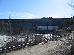
Mountain Chute Dam and Generating Station
-
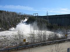
Mountain Chute Dam with spillway sluice gates open
-
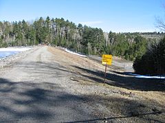
Associated embankment dam nearby


