
Black Loch (New Cumnock) facts for kids
Quick facts for kids Black Loch |
|
|---|---|

Black Loch
|
|
| Lua error in Module:Location_map at line 420: attempt to index field 'wikibase' (a nil value). | |
| Location | East Ayrshire, Scotland |
| Type | Freshwater loch |
| Primary inflows | Polquhap & Segsy Burns, Rainfall and runoff |
| Primary outflows | Blackloch Burn |
| Basin countries | Scotland |
| Max. length | 400 m (1,300 ft) |
| Max. width | 200 m (660 ft) |
| Islands | None |
| Settlements | New Cumnock |
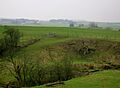
Black Loch is a freshwater loch (a Scottish word for lake). It gets its name from its dark-looking waters. You can find it in the East Ayrshire area of Scotland, between the towns of Cumnock and New Cumnock.
The loch sits in a special dip in the ground called a glacial Kettle Hole. This kind of hole was formed by melting ice from glaciers long ago. Black Loch is famous because it's one of the very few lochs or lakes in the world that has water flowing out in two different directions!
Contents
About Black Loch
Black Loch is about 400 metres long. It is the deepest of three lochs in the New Cumnock area that are connected. Its most amazing feature is its two outflows.
- One outflow goes north into the Glaisnock Water. This water then flows into the Lugar Water, then the River Ayr, and finally reaches the Firth of Clyde on Scotland's west coast.
- The other outflow goes south into the River Nith. This river eventually flows into the Solway Firth, which is on Scotland's south-west coast.
So, water from Black Loch can end up in two completely different seas! Smaller streams like the Segsy Burn and Polquhap also flow into the loch. In very wet weather, all three nearby lochs sometimes join together into one big body of water.
Maps Over Time
Old maps show us how people saw Black Loch over the centuries. A map from the 1600s by Robert Gordon showed only one loch in the area. It only had an outflow going into the River Nith.
Later maps, like Blaeu's map from 1654, also showed one main loch. But it marked a "Black Loch" part at the northern end. Over time, maps started to show the loch more clearly. Some maps even wrongly showed islands in Black Loch! By the 1800s, maps were much more detailed, showing more small streams flowing into the loch.
Who Owned the Land?
The land around Black Loch was part of an area called Boreland. The Hamilton family owned these lands for a very long time, starting in the late 1300s or early 1400s.
Later, in 1669, the land passed to Margaret, a granddaughter of Hugh Hamilton of Boreland. She married Hugh Montgomerie. The Montgomerie family then owned the lands of Boreland until 1751. After that, the land was sold to different people. In 1790, the Earl of Dumfries bought the lands. But by the 1860s, the Marquis of Bute owned them.
Past Uses of the Loch
The Blackloch Burn, which flows out of the loch to the north, was very important. A special gate called a sluice controlled the water flow. This water was used to power an old mill called Borland Mill. The mill had a millpond that collected the water.
By the late 1800s, maps showed that the millpond was no longer used for the mill. Instead, it was just a reservoir, holding water. The loch itself also had lots of plants growing around its edges.
Interesting Stories
Long ago, the Earl of Dumfries had a big plan. He wanted to dig a channel from the River Nith through the nearby Loch o' th' Lowes and Creoch Loch to Black Loch. His idea was to bring more water to power a factory he wanted to build. If this had happened, some of the River Nith's water would have flowed towards the Clyde instead of the Solway! But the factory was never built.
There's also a fun story about a trout. Imagine a trout swimming up the River Ayr, then into the Lugar Water, and then into Black Loch through the Glaisnock Water. From Black Loch, it could swim out the other end into Creoch Loch, then into the Loch o' th' Lowes, and finally into the River Nith. After a journey of about seventy miles, it would end up in the Solway Firth!
Images for kids
-
Entrance lane to old Borland Castle.
-
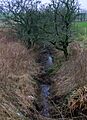
Old lade to Borland Mill from Black Loch.


