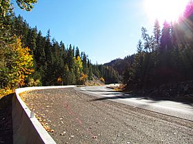
Blewett Pass facts for kids
Quick facts for kids Blewett Pass |
|
|---|---|
 |
|
| Elevation | 4,124 ft (1,257 m) |
| Traversed by | |
| Location | Chelan / Kittitas Counties, Washington, United States |
| Range | Wenatchee Mountains (Cascade Range) |
| Coordinates | 47°20′07″N 120°34′44″W / 47.33528°N 120.57889°W |
Blewett Pass is a mountain pass in Washington state. It is about 4,124 feet (1,257 m) high. A mountain pass is like a low spot or a gap between mountains. It makes it easier to travel from one side to the other. This pass is part of the Wenatchee Mountains. These mountains are an extension of the larger Cascade Range. U.S. Route 97 (US 97) crosses over Blewett Pass. The pass was named after Edward Blewett. He was a person who promoted mining in the 1880s. This pass is also on the route of the old Yellowstone Trail.
Contents
What is Blewett Pass?
Blewett Pass helps people travel through the mountains. It is a key connection in Washington state. The pass is different from many other famous passes. Those passes are usually on the main spine of the Cascade Mountains. Blewett Pass is special because it sits between two rivers. It divides the land between the Wenatchee River to the north and the Yakima River to the south.
Connecting Major Roads
The highway over Blewett Pass connects important roads. It links Interstate 90 (I-90) with U.S. Route 2 (US 2). I-90 runs between cities like Seattle and Ellensburg, Washington. US 2 connects places like Monroe and Wenatchee. If you are traveling from Seattle to Wenatchee, Blewett Pass is a good choice. It offers an alternative route to the one over Stevens Pass.
History of Blewett Pass
The area now called Blewett Pass had a different name before. It was known as Swauk Pass. There is also an Old Blewett Pass. This older pass is about 5 miles (8.0 km) west of the current one. It is a bit lower, at 4,064 feet (1,239 m) high.
Name Change and New Road
The name changed from Swauk Pass to Blewett Pass in the 1960s. This happened after a new highway was built for US 97. Even after the change, many local people preferred the old name. The road for the old pass is now called Forest Road 9715 and Forest Road 7320. This old road closes during the winter. It is used for fun outdoor activities in the snow. If you plan to drive on it when it reopens, it's a good idea to check with the Wenatchee National Forest office first. This way, you can learn about the road conditions.
 | Jewel Prestage |
 | Ella Baker |
 | Fannie Lou Hamer |

