
Blue Hills (Washington) facts for kids
Quick facts for kids Blue Hills |
|
|---|---|

Location in Washington (state)
|
|
| Highest point | |
| Peak | Gold Mountain |
| Elevation | 1,761 ft (537 m) |
| Geography | |
| Country | United States |
| State | Washington |
| Region | Western Washington |
| Range coordinates | 47°33′00″N 122°48′00″W / 47.55000°N 122.80000°W |
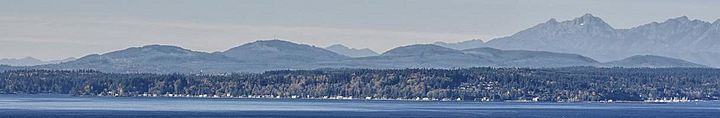
The Blue Hills are a group of hills located just west of Bremerton, Washington. They are also known by other names like the Bremerton Hills, Bald Hills, and Wildcat Hills. The main peaks in this group are Gold Mountain and Green Mountain. There are also several other hills that don't have official names.
The highest point in the Blue Hills is Gold Mountain, which reaches an elevation of 1,761 feet (537 meters). These hills stand out in the landscape, rising high above the flat areas around them. People say they are called "Blue Hills" because the green trees on them look blue when seen from far away, due to how light travels through the air.
Here are some of the other important peaks in the Blue Hills:
- Kitsap Lookout, which is 1,360 feet high.
- Peak 1330 (also known as Peak 1320).
- Peak 1291.
- Peak 730.
You can find a longer list of hills in the area at List of mountains and hills of Kitsap County, Washington.
Contents
How Were the Blue Hills Formed?

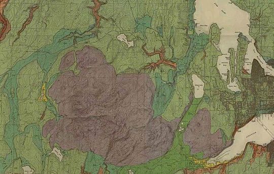
The Blue Hills are made of old ocean floor rocks that were pushed up. This happened about 50 million years ago. Imagine a giant squeeze! This squeeze created big cracks and valleys between the hills. Gold Mountain is mostly made of a type of rock called basalt, which comes from ancient lava flows. Green Mountain is made of slightly older rocks like gabbro and pegmatite.
These hills sit on the northern edge of a large uplift. This uplift is like a big arch in the Earth's crust. It was formed by the land being pushed together from north to south. This pushing also created many cracks in the rocks, called faults. One important fault, the Gold Creek fault, separates Gold Mountain from Green Mountain.
Water Supply and Rivers
The Blue Hills are very important for water. They are the source of several rivers and creeks. These include the Union River and Tahuya River. These rivers flow into the Hood Canal. Other creeks flow north, northeast, and east, providing water to different areas.
The hills are especially important for Bremerton's water supply. The Kitsap Peninsula doesn't have large lakes or rivers. It also doesn't have big mountain reservoirs filled by melting snow. So, the Blue Hills are a key source of fresh water.
A dam called Casad Dam was built on the Union River in 1957. This dam created the Union River Reservoir. This reservoir provides more than half of the water Bremerton needs each year. Most of the land around this water source is owned by Bremerton to protect the water quality.
Fun Things to Do in the Blue Hills

_GM_wsp1413.jpg)
There are many places in and around the Blue Hills where you can have fun outdoors.
Green Mountain State Forest
One of the biggest areas open to the public is Green Mountain State Forest. This forest covers over 6,000 acres. It includes Green Mountain itself. The state forest allows many activities like camping, riding off-road vehicles, horseback riding, and hiking.
Gold Mountain Golf Course
The city of Bremerton owns the land around Gold Mountain for its water supply. Even though most of this area is restricted, the Gold Mountain Golf Course was built on the southern side of the hills.
Other Parks and Trails
Together, the water supply land and Green Mountain State Forest make up more than half of Kitsap County's open spaces.
The Mountaineers group has an outdoor theater called Kitsap Forest Theater. It's located in their Rhododendron Preserve on the north side of the hills.
There are also several county and city parks where you can enjoy nature:
- City of Bremerton
- Gold Mountain Golf Course
- Newberry Hill Heritage Park
- Otto Jarstad Park
- Pendergast Regional Park
- Kitsap County
- Wildcat Lake Park
- Central Kitsap Greenways
- Navy Yard City Open Space
