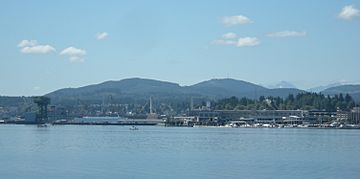
Gold Mountain (Washington) facts for kids
Quick facts for kids Gold Mountain |
|
|---|---|

Gold Mountain behind the Puget Sound Naval Shipyard in Bremerton
|
|
| Highest point | |
| Elevation | 1,761 feet (537 m) |
| Geography | |
| Location | Kitsap County, Washington, United States |
| Parent range | Blue Hills |
| Topo map | USGS Bremerton West |
Gold Mountain is a tall peak in Washington state. It is part of the Blue Hills on the Kitsap Peninsula. Standing at 1,761 feet (537 meters), it is the highest point on the Kitsap Peninsula. It is also the tallest spot in Kitsap County. Nearby Green Mountain is the second highest peak.
Gold Mountain is not fully open to everyone. Some parts are on private land. Other parts are in the City of Bremerton watershed. A watershed is an area of land where all the water drains into a specific river or lake. This area helps supply drinking water to the city.
However, a large part of the mountain is in the Green Mountain State Forest. This forest covers about 6,000 acres (2,400 hectares). It is open for fun activities like hiking and horseback riding. You can also use on- and off-road vehicles there. The very top of Gold Mountain is actually a small part of this state forest. It is located about 6 miles (9.7 km) west of downtown Bremerton.
Contents
Why is Gold Mountain Important for Communication?
The top of Gold Mountain is a busy place for signals. It has many antennas and transmitters. These are used for important communication.
How Emergency Services Use the Mountain
The mountain summit helps local emergency services. This includes police, fire, and ambulance teams. Their radios use the transmitters on Gold Mountain. This helps them talk to each other across the Kitsap Peninsula. It makes sure help can arrive quickly when needed.
Television and Radio Signals
Many TV and radio stations use Gold Mountain. Their transmitters send out signals from the top. This allows people in the Puget Sound region to watch and listen. For example, TV stations like KCPQ (Fox 13) and KTBW use the mountain. Radio stations also send their signals from here.
Amateur Radio and GPS
Since 1981, a special amateur radio group has used the mountain. They operate a "repeater" called WW7RA. This device helps amateur radio users talk to people far away. It covers a wide area from Centralia to Bellingham.
There is also a special GPS station on the mountain. It helps with very accurate measurements of the Earth. This is called geodesy. It uses GPS signals to track tiny changes in the Earth's surface.
 | James Van Der Zee |
 | Alma Thomas |
 | Ellis Wilson |
 | Margaret Taylor-Burroughs |

