
Bluff Knoll facts for kids
Quick facts for kids Bluff Knoll |
|
|---|---|
 |
|
| Highest point | |
| Elevation | 1,099 m (3,606 ft) |
| Prominence | 650 m (2,130 ft) |
| Geography | |

Bluff Knoll
Location in Western Australia
|
|
| Parent range | Stirling Range |
Bluff Knoll is a famous mountain in Western Australia (WA). It is the highest peak in the Stirling Range. This mountain stands 1,099 metres (3,606 ft) above the sea.
Many people think Bluff Knoll is the highest point in Western Australia. But the actual highest peak is Mount Meharry. Mount Meharry is in Karijini National Park and is 1,249 metres (4,098 ft) tall.
Local Aboriginal groups, like the Qaaniyan and Koreng people, have special names for Bluff Knoll. They called it Pualaar Miial. This means "great many-faced hill" or a place of "many eyes." The Noongar people also have old stories about the mountain. They believed the mist around the peaks was a spirit.
Climbing Bluff Knoll
Climbing Bluff Knoll is a popular activity. The round trip is about 6 kilometres (3.7 mi) long. It usually takes three to four hours to complete. Most people with good fitness can make it to the top.

From the summit, you can see amazing views. You can look out over the Stirling and Porongurup mountain ranges. You can also see the coast near Albany.
The lower parts of the mountain have many young Eucalypt trees. Sometimes, these trees can catch fire. This can happen after lightning strikes, like the one in 2010.
How Bluff Knoll Formed
Bluff Knoll and the rest of the Stirling Range formed a very long time ago. This happened when Australia began to separate from Antarctica. As the two continents slowly moved apart, a large crack opened up.
First, the western part of this crack opened. Then, the eastern part started to open too. The continents turned slightly, which pushed the rocks at the western end. This pushing forced the old sediments upwards. This is how the Stirling Range was created. The rocks that folded up are about 1.2 billion years old. The mountains are mostly made of sedimentary rocks. These include sandstone, quartzite, slate, and shale.
Governor James Stirling gave the peak its name. He named it as the highest point in the Stirling Range.
Weather and Snow
Bluff Knoll is one of the few places in Western Australia that gets snow. Snow is reported on the mountain in most years.
One heavy snowfall happened on 6 October 1992. About 20 centimetres of snow fell that day. Light snow was even seen at the base of the mountain. In 2016, snow fell three times. This was more than in 2015, when it only snowed once.
On 19 April 2019, a light snowfall was recorded. This was the earliest snow event ever recorded in Western Australia for that year.
Images for kids
-
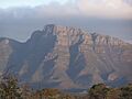
Bluff Knoll from a distance.
See also
 In Spanish: Bluff Knoll para niños
