Bolaños River facts for kids
Quick facts for kids Bolaños River |
|
|---|---|

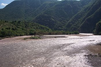
The Bolaños River as it reaches the Lerma Santiago River
|
|
| Country | Mexico |
| Physical characteristics | |
| Main source | Zacatecas |
| River mouth | Lerma Santiago River |
| Length | 360 km (220 mi) |
| Basin features | |
| Basin size | Lerma Santiago River |
The Bolaños River is an important river in Mexico. It flows through a mountain range called the Sierra Madre Occidental. This river is a smaller stream that flows into a bigger river, the Rio Grande de Santiago. The Bolaños River is about 360 kilometers (224 miles) long. It collects water from an area of about 10,000 square kilometers (3,861 square miles), which is called its watershed.
Contents
Where Does the Bolaños River Flow?
Starting Point and Journey
The Bolaños River begins in the state of Zacatecas, Mexico. This is about 60 kilometers (37 miles) west of a city called Fresnillo. It's also about 40 kilometers (25 miles) south of the Tropic of Cancer, an imaginary line around the Earth.
As the river flows, it heads south. It travels between two mountain ranges: the Sierra los Huicholes to the west and the Sierra de Morones to the east. After about 85 kilometers (53 miles), the river enters the state of Jalisco.
Meeting Another River
Eventually, the Bolaños River flows into the Lerma Santiago River. This meeting point is about 40 kilometers (25 miles) northwest of the famous town of Tequila. The last 32 kilometers (20 miles) of the Bolaños River actually form the border between the states of Jalisco and Nayarit.
Towns Along the River
The Bolaños River passes through several towns and areas. These include:
- In Zacatecas: San Mateo and Valparaiso.
- In Jalisco: Mezquitic, Villa Guerrero, Bolaños, Chimaltitán, and San Martín de Bolaños.
See also
 In Spanish: Río Bolaños para niños
 | William L. Dawson |
 | W. E. B. Du Bois |
 | Harry Belafonte |

