
Bondi Junction facts for kids
Quick facts for kids Bondi JunctionSydney, New South Wales |
|||||||||||||||
|---|---|---|---|---|---|---|---|---|---|---|---|---|---|---|---|
Westfield_Bondi_Junction-987.jpg)
Westfield Bondi Junction
|
|||||||||||||||
| Established | 1854 | ||||||||||||||
| Postcode(s) | 2022 | ||||||||||||||
| Elevation | 85 m (279 ft) | ||||||||||||||
| Area | 1.07 km2 (0.4 sq mi) | ||||||||||||||
| Location | 6 km (4 mi) east of Sydney CBD | ||||||||||||||
| LGA(s) | Waverley Council | ||||||||||||||
| State electorate(s) |
|
||||||||||||||
| Federal Division(s) | Wentworth | ||||||||||||||
|
|||||||||||||||

Bondi Junction is a busy area in the eastern part of Sydney, New South Wales, Australia. It's about 6 kilometres east of the main city centre of Sydney. This suburb is part of the Waverley local government area.
Bondi Junction is mostly a commercial hub, meaning it has lots of shops and businesses. It has changed a lot since the late 1900s. Many new shops and homes have been built, especially around the main street. A big new bus and train station and a large shopping mall are key features. Some old pubs, like the Nelson Hotel, are still there. Nearby suburbs include Bondi Beach, famous for its beach, and also Bondi and North Bondi.
The area is also well known for its famous rugby league team, the Sydney Roosters. They are officially called the Eastern Suburbs District Rugby League Football Club.
Contents
Exploring Bondi Junction's Past

The name Bondi comes from an Aboriginal word. It means water breaking over rocks. Over time, people spelled it in different ways, like Boondi or Bundi.
The very first house in this area was Waverley House. Barnett Levey built it in 1827. It was located where Waverley Street is today. The house was sold many times before it was taken down in 1904. When the Waverley Municipality was created in 1859, it got its name from Waverley House.
In 1832, Henry Hough received a land grant in Bondi Junction. He built a flour mill there that used wind power. A track from South Head Road, now Oxford Street, led to his mill. Oxford Street is still the main road in the suburb.
The first hotel, The Waverley Tea Gardens, opened in 1854. The area around it quickly became known as "Tea Gardens." This name stuck for about 30 years. By 1878, steam power replaced wind power for milling, and the mill closed. In May 1881, the land was divided into smaller blocks. Streets like Mill Hill Road and Hough Street still exist from this time.
The subdivision happened around the same time the first tramway opened. Steam trams started running from Taylor Square in Darlinghurst on March 12, 1881. Later, tram lines were extended to Bondi Beach, Charing Cross, and Bronte. This is when the name Bondi Junction was created. It referred to where the Bondi and Bronte tram lines met. This was at the corner of what is now Oxford Street and Bronte Road.
By 1930, Bondi Junction had grown into a major centre for shopping and entertainment. Tram lines connected it to many places, including Bondi Beach, Bronte Beach, and the city. A tram depot was built on Oxford Street. Oxford Street became very busy and crowded. By the 1960s, it was one of the most congested places in Sydney.
Historically, Bondi Junction was split between two councils: Waverley and Woollahra. In 2002, the boundary was changed. This gave Waverley Council full control over the main shopping areas.
Getting Around Bondi Junction
Bondi Junction railway station is an underground train station. It is the last stop on the Eastern Suburbs railway line for Sydney Trains. Some trains from the South Coast Line also end here. Above the train station, there is a bus interchange. This is where many buses stop, and it's located below some residential buildings.
The Sydney tram network closed in 1961. The Waverley Tram Depot then became a bus depot. This helped with traffic for a while. However, more and more people started using private cars. This made traffic problems worse again.
A railway line to Sydney's eastern suburbs was first suggested in the 1870s. This idea was later included in the Bradfield Scheme. This was a big plan to improve Sydney's railways. However, the line was not built exactly as Bradfield planned.
In 1976, construction of the railway was underway. The government decided to finish the project all the way to Bondi Junction. At the same time, work began on a special elevated road to bypass Bondi Junction. This road, later named Syd Einfeld Drive, opened quickly on January 6, 1979. It runs around the northern side of the business area. It is built about five metres above the ground. This freeway was actually the only part ever built of a much larger road. That larger road, the Eastern Freeway, was planned to go between the Sydney city centre and Bondi.
When the railway opened in June 1979, traffic in Bondi Junction changed a lot. The main road, Oxford Street, became only for buses in some parts. A pedestrian area was created between Bronte Road and Newland Street. This area is known as Bondi Junction Mall. The new railway helped to organize bus services in the Eastern Suburbs. Many buses that used to go to the city now ended at the new Bondi Junction Bus–Rail Interchange.
In 1998, Woollahra Council sold the space above the bus interchange. This allowed for new buildings to be constructed. In April 1999, work started on a new bus interchange. Two tall apartment towers, over 70 metres high, were also built. The Bondi Junction railway station was also upgraded during this time. The new interchange opened for the Sydney Olympics in September 2000. It then closed for more work and fully reopened in July 2001.
Shopping and Living in Bondi Junction
Retail and Shopping Fun
Bondi_Junction_060.jpg)

Oxford_Street_Mall-9999a.jpg)
Westfield Bondi Junction is a very large shopping centre. It is located across from Bondi Junction railway station. It has many mid to high-end shops. There are also two smaller shopping centres nearby. One is Eastgate Bondi Junction, which is below some apartments. Another is above the station and bus interchange, called Meriton Retail Precinct Bondi Junction.
Oxford Street is a major shopping street in Bondi Junction. It has many businesses, including hotels and shops. The Oxford Street Mall is a special area just for people walking. It is between Bronte Road and Newland Street and has many shops and cafes. You can also find shops along Spring Street, Ebley Street, and Bronte Road.
Tall Buildings and Homes
Vue_139.jpg)

Bondi Junction is Sydney's fifth largest business district. It's a very important area for businesses, after the city centre, North Sydney, Parramatta, and Chatswood. Most commercial buildings here are two or three levels high. However, over the last 35 years, more than twenty buildings with 12 or more levels have been built. This includes the Bondi Junction Private Hospital.
One of the first big developments was the Eastern Suburbs Leagues Club. This is the local rugby league club for the Eastern Suburbs Roosters team.
In the 1980s, after the Eastern Suburbs Railway was finished, many office buildings were built. But by the 1990s, many of these were replaced by residential buildings.
Bondi Junction has many tall apartment buildings close to the shops. Further away, you can find houses with more space. The older houses often have Victorian and Federation styles.
People and Culture
According to the 2021 Census, 10,361 people live in Bondi Junction. About 42% of residents were born in Australia. Other common birthplaces include England (9%), Brazil (3.8%), and Ireland (3.2%). Most people (64.2%) speak only English at home. Other languages spoken include Mandarin (3.7%) and Portuguese (3.6%). When it comes to religion, many people (41.1%) reported having no religion. Other common religions include Catholic (20.6%) and Judaism (11.2%).
Sports and Fun
Bondi Junction is home to the Sydney Roosters rugby league team. They play in the National Rugby League. Their clubhouse is on Spring Street in Bondi Junction. Many locals call the area "the home of the Roosters."
Special Places and Old Buildings
Bondi Junction has many buildings and places that are important to its history. These are called heritage-listed items.
The Waverley Reservoirs on Paul Street is a very important heritage site.
Here are some other locally heritage-listed buildings:
- Italianate home used as a community health centre, 26 Llandaff Street
- Ben Eden, Paul Street
- Blair Athol, Woodstock Street
- Euston, Woodstock Street
- Charles Terrace, Denison Street
- Glen Mervyn, Denison Street
- Myall, Mill Hill Road
- Cintra, Mill Hill Road
- Congregationalist Church, Botany Street
- Clementson Park, Ebley Street
- Fingleton Reserve, Waverley Crescent
- Hallena, Waverley Street
- Cotswald Hall, Dalley Street
- Waverley Library
Images for kids
-
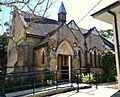
Congregationalist Church, Botany Street
-
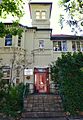
Bondi Junction Community Health Centre, Llandalff Street
former_Congregationalist_Church_Botany_Street-2.jpg)
Italianate_house_Llandaff_Street.jpg)
