Borders of Palestine facts for kids
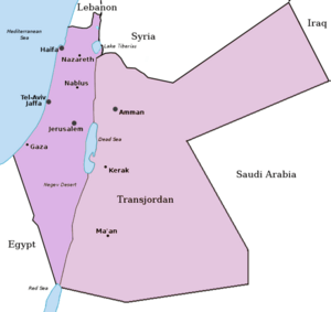
Palestine is a region in the Middle East. It has important borders with several countries. These borders define where Palestine ends and other countries begin. Understanding borders helps us learn about geography and how countries connect.
Contents
Understanding Palestine's Borders
International borders are lines that separate countries. They are like invisible fences on a map. These lines show where one country's land ends and another's begins. Borders are important for trade, travel, and keeping peace between nations.
What Are International Borders?
Every country has borders. They are agreed upon by different nations. Sometimes, natural features like rivers or mountains form borders. Other times, they are straight lines drawn on a map. These lines help define the size and shape of a country.
Palestine's Neighboring Countries
Palestine shares its borders with several countries. To the north, it borders Lebanon. To the northeast, it borders Syria. These countries are part of the wider Middle East region.
Eastern and Southern Borders
To the east, Palestine borders Jordan. Jordan is a large country with its own borders. Jordan also shares borders with Saudi Arabia and Iraq further east. This shows how countries are connected through their borders.
To the southwest, Palestine borders Egypt. Egypt is known for its ancient history and the Nile River. The border with Egypt also includes a shared maritime (sea) boundary in the Red Sea. This means their territories meet in the water as well as on land.
Why Borders Are Important
Borders are very important for many reasons. They help control who enters and leaves a country. They also help countries manage their resources and protect their land. Borders are a key part of how countries work together and manage their relationships.
 | DeHart Hubbard |
 | Wilma Rudolph |
 | Jesse Owens |
 | Jackie Joyner-Kersee |
 | Major Taylor |


