Borough of Swale facts for kids
Quick facts for kids
Borough of Swale
|
|
|---|---|
|
Non-metropolitan district
|
|

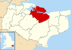
Swale shown within Kent
|
|
| Sovereign state | United Kingdom |
| Constituent country | England |
| Region | South East England |
| Non-metropolitan county | Kent |
| Status | Non-metropolitan district |
| Admin HQ | Sittingbourne |
| Incorporated | 1 April 1974 |
| Government | |
| • Type | Non-metropolitan district council |
| • Body | Swale Borough Council |
| Area | |
| • Total | 144.2 sq mi (373.4 km2) |
| Area rank | 110th (of 326) |
| Population
(2005 est.)
|
|
| • Total | 150,082 |
| • Rank | 137th (of 326) |
| • Density | 1,041.00/sq mi (401.93/km2) |
| • Ethnicity | 96.1% White 1.3% S.Asian 1.1% Black 1.0% Mixed Race |
| Time zone | UTC0 (GMT) |
| • Summer (DST) | UTC+1 (BST) |
| ONS code | 29UM (ONS) E07000113 (GSS) |
Swale is a special area in Kent, England. It has its own local government, which means it manages its own services. This area is known as a 'borough'.
Swale is next to other places like Medway to the west. To the east, you'll find Canterbury. Ashford is to the south, and Maidstone is to the southwest. The main office for Swale's local government is in Sittingbourne.
The area is named after a narrow water channel called The Swale. This channel separates the main part of Kent from the Isle of Sheppey. The channel runs right through the middle of the district.
Swale was officially created in 1974. This happened because of a law called the Local Government Act 1972. Before that, Swale was made up of smaller areas. These included the towns of Faversham, Queenborough-in-Sheppey (which covered the whole Isle of Sheppey), and the Sittingbourne and Milton area. It also included the Swale Rural District.
Most of the southern part of Swale is a beautiful natural area. It's part of the Kent Downs Area of Outstanding Natural Beauty. Sittingbourne and the Isle of Sheppey are also part of the Thames Gateway. This is an area planned for growth and development.
There are four main towns in the Swale borough. Sittingbourne and Faversham are on the mainland. Sheerness and Queenborough are on the Isle of Sheppey.
What Swale is Like
Swale is mostly a rural area. This means it has lots of countryside and farms. It's famous for its many fruit orchards. These grow apples, pears, cherries, and plums. You can also find many hop gardens here. Hops are used to make beer.
Sheerness is a busy port. A port is a place where ships load and unload goods. In the past, Sheerness also produced steel. Sittingbourne has different types of smaller industrial businesses.
Getting Around Swale
The ancient Roman road called Watling Street used to go through this area. You can still see how straight the A2 main road is today. This road is now bypassed by the M2 motorway. A motorway is a big highway for fast travel.
Swale also has two railway lines. These are the Chatham Main Line and the Sheerness Line. They both meet at the town of Sittingbourne.
See also
 In Spanish: Swale para niños
 | Madam C. J. Walker |
 | Janet Emerson Bashen |
 | Annie Turnbo Malone |
 | Maggie L. Walker |


