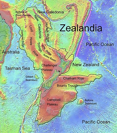
Bounty Trough facts for kids

The Bounty Trough is a huge underwater valley in the southwest Pacific Ocean. It's like a big dip in the ocean floor, found off the east coast of New Zealand's South Island. This trough is named after the Bounty Islands, which are located near its eastern end. The islands themselves got their name from the famous ship, HMS Bounty.
Where is the Bounty Trough?
The Bounty Trough is located south of the Chatham Rise and north of the Campbell Plateau. It stretches from west to east for about 800 kilometers (500 miles). It reaches the deep ocean between the Chatham Islands and the Bounty Islands. The western part of the Bounty Trough is very close to the South Island's coast, less than 50 kilometers (30 miles) away. In total, this underwater valley covers a huge area of about 100,000 square kilometers (38,600 square miles).
Most of the Bounty Trough is very deep, usually between 2,000 and 3,000 meters (6,500 to 9,800 feet) below the surface. It forms a noticeable dip in the edge of Zealandia, which is a continent mostly hidden underwater.
How the Bounty Trough Formed
One interesting thing about the Bounty Trough is that it seems to be a continuation of some major river systems on the South Island, like the Clutha River and Waitaki River. These rivers, especially the Clutha, are known for flowing very fast.
The Bounty Trough has distinct channels at its base, which are like underwater riverbeds. These channels were likely shaped by a lot of sediment (like sand and mud) that was carried by rivers during the ice ages.
The channel system is actually what's left of a "failed rift" that formed during the Cretaceous Period. This was a time, between 130 and 85 million years ago, when Zealandia began to separate from Antarctica. The channels act as a major pathway for sediments coming from the big rivers on the eastern side of the South Island. At the eastern end of this rift, there's a large, deep fan-shaped deposit of sediment called the Bounty Fan.
In 2012, a research ship named RV Tangaroa from the NIWA explored and mapped this area. They found a structure with nine canyons that ended in a large, apron-shaped sediment deposit within the Bounty Trough. This mapping helped scientists understand the area's environment. The survey also found some "pock marks" on the edges of the trough. These were about 20 meters (65 feet) deep and 200 meters (650 feet) wide, and they might show where methane gas is seeping out from the seafloor.
Both the Otago and abyssal fans, and the rift itself, developed a lot faster after about 2.5 million years ago. This was when global climate cycles of ice ages and warmer periods began, and an icecap formed along the alpine region of the South Island. During the glacial periods, huge amounts of sediment were carried into the trough. Today, sediment isn't being deposited in the same way as it was during those icy times.
 | Emma Amos |
 | Edward Mitchell Bannister |
 | Larry D. Alexander |
 | Ernie Barnes |

