Campbell Plateau facts for kids
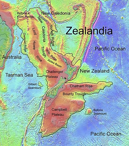
The Campbell Plateau is a huge underwater land area found south of New Zealand. It's like a giant shelf on the ocean floor. This plateau was formed when the ancient supercontinent Gondwana broke apart a very long time ago. It's actually part of Zealandia, which is a continent that is mostly hidden underwater.
Some parts of the Campbell Plateau stick out above the sea. These are the Bounty Islands, Antipodes Islands, Auckland Islands, and Campbell Island. These islands are so special that they are part of the New Zealand Subantarctic Islands, which became a World Heritage Site in 1998.
Most of the Campbell Plateau is less than 1,000 meters (about 3,300 feet) below the ocean surface. Some parts, like the Pukaki Rise, are even shallower, rising to 500 meters (about 1,640 feet) below the surface. The Auckland and Campbell Islands are the parts that actually rise above the water.
This massive plateau covers an area of about 800,000 square kilometers (308,880 square miles). The ocean floor here isn't perfectly flat; it has gentle hills and valleys. There are also some main ridges that run from east to west, like the Campbell Island Rise and the Pukaki Rise.
What is the Campbell Plateau made of?
The Campbell Plateau is a roughly triangular piece of continent that formed when Gondwana broke up about 80 million years ago. Much of the plateau is made of very old rocks, like granite. On top of these old rocks, there are younger volcanoes. These volcanoes formed the Auckland and Campbell Islands.
Even though the Campbell Plateau is made of continental rock, it's unusually thin for a continent. Scientists are still discussing why this is. One idea is that the land stretched a lot a long time ago. Another idea is that it became thin when New Zealand and Antarctica separated. This stretching also created a large area called the Great South Basin, where about 8 kilometers (5 miles) of sand and mud have built up over time. The Bounty Trough was also formed during this process.
The islands on the plateau are made of continental rocks. For example, the Auckland, Snares, and Stewart islands have a base of granite rocks that are about 100 to 120 million years old. Campbell Island has even older rocks, called schists. The Bounty Islands are made of granite-like rocks that are about 189 million years old. However, the Antipodes Islands are different; they are made of much younger volcanic rocks.
Scientists believe that before Gondwana broke apart, the Campbell Plateau was connected to other landmasses, like the Lord Howe Rise and the Ross Sea. These areas have similar rock thicknesses and went through similar changes before the breakup.
There are also two special areas on the Campbell Plateau where Earth's magnetic field is unusual. Scientists call these the Stokes Magnetic Anomaly System and the Campbell Magnetic Anomaly System. They are still trying to understand exactly how these magnetic areas formed.
Amazing Wildlife
The islands on the Campbell Plateau are very important homes for many unique animals. Some of these animals live only in this area, while others travel all around the southern oceans.
These islands are major breeding grounds for:
- The Southern royal albatross, a very large seabird.
- Different types of crested penguins.
- The New Zealand sea lion, also known as Hooker's sea lion.
The southern part of New Zealand's South Island (areas like Fiordland, Southland, and Otago) is connected to the Campbell Plateau. This connection is seen in both the types of rocks and the kinds of plants and animals found there. For example, certain spiders, frogs, and many types of beetles are found in both the southern South Island and the New Zealand Subantarctic Islands. Even moths and butterflies show this connection.
Macquarie Island is another island that shares many animals with the Campbell Plateau, even though it's not geologically connected. Macquarie Island was formed by volcanic activity far away. However, because of how ocean currents move, many animals have traveled between the two areas. This includes several types of beetles, a fly, and a special plant genus called Pleurophyllum.
Ocean Currents Around the Plateau
South of the Campbell Plateau, a powerful ocean current called the Antarctic Circumpolar Current (ACC) flows eastward. This current is like a giant river in the ocean, carrying a huge amount of water. It reaches New Zealand and then partly flows into the Tasman Sea.
The main part of the ACC, however, flows around the Macquarie Ridge and then turns north along the eastern side of the Campbell Plateau. It eventually turns eastward again. There are also winds that push surface water across the Campbell Plateau.
Another important current is the Southland Current. This current flows around the South Island of New Zealand and then moves north-east along the island's east coast. It picks up water from both cold southern areas and warmer northern areas as it flows across the north-western part of the Campbell Plateau.
 | Percy Lavon Julian |
 | Katherine Johnson |
 | George Washington Carver |
 | Annie Easley |


