Bradfield, South Yorkshire facts for kids
Quick facts for kids Bradfield |
|
|---|---|
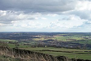
 View of the Loxley Valley in Bradfield parish |
|
| Population | 17,100 (2011 census) |
| OS grid reference | SK 251 916 |
| Civil parish |
|
| Metropolitan borough | |
| Metropolitan county | |
| Region | |
| Country | England |
| Sovereign state | United Kingdom |
| Post town | SHEFFIELD |
| Postcode district | S6 |
| Dialling code | 0114 |
| Police | South Yorkshire |
| Fire | South Yorkshire |
| Ambulance | Yorkshire |
| EU Parliament | Yorkshire and the Humber |
| UK Parliament |
|
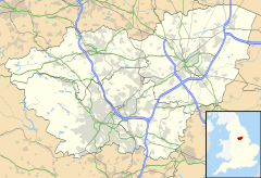
Bradfield is a large area in South Yorkshire, England. It is part of the City of Sheffield.
This area is very big. The western part is covered in wild moorlands, which are part of the beautiful Peak District National Park. The eastern part has lower land used for farming. This is where most people live.
Important places in Bradfield include the Sheffield suburb of Stannington. You can also find the villages of Oughtibridge, Worrall, High Bradfield, and Low Bradfield here. Bradfield is also home to several large reservoirs. It's about 8 miles (13 km) from Sheffield city centre.
On July 6, 2014, a famous bike race called the Tour de France came through Bradfield. It was part of Stage 2, which went from York to Sheffield. Bradfield was even home to a tough climb called the Côte de Bradfield. It was 1 kilometre (0.62 mi) long and very steep. A cyclist named Andriy Hrivko won the point for being first to the top of this climb.
Exploring Bradfield's Landscape
Bradfield is one of the biggest parishes in England. It covers a huge amount of moorland and farmland. You'll find several large reservoirs here, like Damflask Reservoir, Dale Dike Reservoir, Strines Reservoir, and Agden Reservoir.
The western side of Bradfield reaches into the Upper Derwent Valley. Part of its border even forms the line between Yorkshire and Derbyshire. In the north, Bradfield includes Langsett Reservoir and Midhope Reservoir. It also borders the town of Stocksbridge.
Villages and Settlements
The eastern edge of Bradfield touches the city of Sheffield. This area includes the suburb of Stannington. Other villages you'll find are Oughtibridge, Wharncliffe Side, and Worrall.
Smaller places in Bradfield include Midhopestones, Upper Midhope, and Bolsterstone in the north. Dungworth is located in the southeastern part.
The moorland villages of High Bradfield and Low Bradfield are also within the parish. High Bradfield has an old church built in a Gothic revival style. It also has the remains of an ancient castle mound. Low Bradfield is a newer village. Much of it was rebuilt after a big flood in 1864.
Bradfield's Population
In 2001, about 14,915 people lived in Bradfield. By 2011, the population had grown to 17,100 people.
The parish of Bradfield is so large that it covers more than a third of the land area of Sheffield City Council. It includes parts of the Stocksbridge and Upper Don, and Stannington electoral wards.


