
Bramble Cay facts for kids
|
Native name:
Maizab Kaur
|
|
|---|---|
.png) |
|

A map of the Torres Strait Islands in the waters of Torres Strait; Bramble Cay labeled in red in upper right
|
|
| Geography | |
| Location | Torres Strait/Coral Sea |
| Coordinates | 9°8'23"S, 143°52'54"E |
| Archipelago | Torres Strait Islands |
| Major islands | Bramble Cay, Black Rocks |
| Area | 0.0362 km2 (0.0140 sq mi) |
| Length | 0.251 km (0.156 mi) |
| Width | 0.104 km (0.0646 mi) |
| Highest elevation | 3 m (10 ft) |
| Highest point | Mount Sikeran |
| Administration | |
|
Australia
|
|
| State | Queensland |
| Shire | Shire of Torres |
| Island Region | Eastern Islands |
| Demographics | |
| Population | 7 (Tourists) |
| Pop. density | 0 /km2 (0 /sq mi) |
| Ethnic groups | Torres Strait Islanders |
| Additional information | |
| Northernmost point of Australia Green turtle breeding place |
|
Bramble Cay, also known as Maizab Kaur, is a tiny island at the very top of Australia. It is part of the Torres Strait Islands in Queensland. This small island is the northernmost point of land in Australia. It sits at the northern end of the famous Great Barrier Reef. Bramble Cay is about 55 kilometers (34 miles) southeast of the Fly River in Papua New Guinea.
What is Bramble Cay Like?
Bramble Cay is a small sand island, covering about 3.62 hectares (9 acres). Most of it is covered in grass. The island was formed from old volcanic rock. It is made up of sand, compacted bird droppings (called guano), and some low rocky areas.
European explorers on a ship called HMS Bramble first found the island in April 1845. That's how Bramble Cay got its name.
In 1862, a company got permission to mine for low-quality rock on the island. However, because the rock wasn't very good, no one stayed there permanently.
After several shipwrecks nearby, a lighthouse was built on Bramble Cay in 1924. It was a tall steel tower, about 13 meters (42 feet) high. This first lighthouse was taken down in 1954. A new, stainless steel lighthouse was built in its place. Since 1987, this lighthouse has been powered by solar energy. Ships from the Australian Maritime Safety Authority visit every few months to check on it.
Wildlife on Bramble Cay
Bramble Cay is a very important place for green turtles. Many green turtles come here to lay their eggs. The ocean around the island is full of algae and fish that love to eat it. You can find fish like unicornfish, wrasse, and trumpetfish swimming in these waters.
The island was also home to a small mouse-like animal called the Bramble Cay melomys. This unique animal lived only on Bramble Cay. Sadly, it was the first mammal species to become extinct because of human-caused climate change.
About 5 kilometers (3 miles) southwest of Bramble Cay are the Black Rocks, also called Rebes. These rocks stick out about one meter (3 feet) above the water. Maps also show a place called Nautilus Reef about 3 kilometers (2 miles) northeast. However, it's not certain if this reef truly exists.
Bramble Cay and the nearby reefs are separated from other islands to the south by a waterway called Bligh Channel. To the north, the Great North East Channel separates them from the coast of Papua New Guinea. Papua New Guinea is about 48 kilometers (30 miles) north of Bramble Cay.
Who Manages Bramble Cay?
Bramble Cay is managed as part of the Shire of Torres in Queensland, Australia. Even though the island is close to the border with Papua New Guinea, Australia clearly owns it, and Papua New Guinea agrees.
The people of Darnley Island have traditional ownership rights over Bramble Cay. Darnley Island is the closest inhabited island, about 45 kilometers (28 miles) to the south. People from Darnley Island travel to Bramble Cay to collect turtle and bird eggs during nesting season. They also allow people from nearby islands like Stephens Island and Murray Island to collect eggs there.
The closest uninhabited island is Underdown Islet, about 40 kilometers (25 miles) south. The country of Papua New Guinea, specifically Parama Island, is about 48 kilometers (30 miles) west-northwest. The city of Daru, the capital of Western Province in Papua New Guinea, is about 70 kilometers (43 miles) west of Bramble Cay.
Images for kids
-
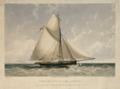
European surveyors from HMS Bramble encountered the island in the 1840s.
-
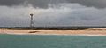
Bramble Cay, as seen from a boat in 2014.

