
Greig, New York facts for kids
Quick facts for kids
Greig, New York
Brantingham
|
|
|---|---|

Greig, New York
Location in New York

Greig, New York
Location in the United States
|
|
| Country | United States |
| State | New York |
| County | Lewis |
| Established as Brantingham | 1828 |
| Name changed to Greig | 1832 |
| Area | |
| • Total | 94.36 sq mi (244.40 km2) |
| • Land | 92.99 sq mi (240.85 km2) |
| • Water | 1.37 sq mi (3.55 km2) |
| Elevation | 1,237 ft (377 m) |
| Population
(2010)
|
|
| • Total | 1,199 |
| • Estimate
(2016)
|
1,206 |
| • Density | 12.97/sq mi (5.01/km2) |
| Time zone | UTC-5 (Eastern (EST)) |
| • Summer (DST) | UTC-4 (EDT) |
| ZIP code |
13345
|
| Area code(s) | 315 |
| FIPS code | 36-049-30796 |
| GNIS feature ID | 979026 |
Greig is a small town located in Lewis County, New York, in the United States. It was named after a person called John Greig, who was a Congressman.
The town of Greig was first created in 1828. It was formed from a part of the nearby town of Watson. When it was first established, it was called "Brantingham." However, in 1832, its name was changed to Greig. Even today, "Brantingham" is still a small community within Greig's borders. It's also the name of a postal area and a lake, Brantingham Lake, located to the east of the town.
In 2010, about 1,199 people lived in Greig.
Contents
Where is Greig Located?
Greig covers a total area of about 94.4 square miles (244.4 square kilometers). Most of this area, about 93.0 square miles (240.85 square kilometers), is land. The rest, about 1.4 square miles (3.55 square kilometers), is water.
The eastern edge of the town is the border with Herkimer County. The western edge of Greig is marked by the Black River.
A large part of the eastern side of the town is located inside the Adirondack Park. This is a very large protected area known for its beautiful nature.
How Many People Live in Greig?
The number of people living in Greig has changed over the years. Here's a quick look at the population from different years:
| Historical population | |||
|---|---|---|---|
| Census | Pop. | %± | |
| 1830 | 662 | — | |
| 1840 | 592 | −10.6% | |
| 1850 | 1,074 | 81.4% | |
| 1860 | 1,733 | 61.4% | |
| 1870 | 2,638 | 52.2% | |
| 1880 | 1,570 | −40.5% | |
| 1890 | 1,481 | −5.7% | |
| 1900 | 1,100 | −25.7% | |
| 1910 | 807 | −26.6% | |
| 1920 | 635 | −21.3% | |
| 1930 | 821 | 29.3% | |
| 1940 | 747 | −9.0% | |
| 1950 | 642 | −14.1% | |
| 1960 | 693 | 7.9% | |
| 1970 | 774 | 11.7% | |
| 1980 | 1,115 | 44.1% | |
| 1990 | 1,323 | 18.7% | |
| 2000 | 1,365 | 3.2% | |
| 2010 | 1,199 | −12.2% | |
| 2016 (est.) | 1,206 | 0.6% | |
| U.S. Decennial Census | |||
In the year 2000, there were 1,365 people living in Greig. These people lived in 533 homes, and 386 of these were families. The town had about 15 people per square mile (5 people per square kilometer).
Most of the people in Greig were White (about 98.9%). A very small number were Native American, Asian, or Pacific Islander. Some people were also of Hispanic or Latino background.
About 30% of the homes had children under 18 living there. Most homes (60.6%) were married couples living together. About 21.6% of all homes were single people living alone.
The average age of people in Greig was 40 years old. About 24.8% of the population was under 18. About 14.6% of the population was 65 years or older.
In 2000, the average income for a household in Greig was about $35,179 per year. For families, the average income was about $39,028.
Communities and Lakes in Greig
Greig is home to several small communities and beautiful lakes. Here are some of them:
- Brantingham – This is a small community located near the middle of the town. It is inside the Adirondack Park.
- Brantingham Lake – This is a lake found to the east of the Brantingham community.
- Catspaw Lake – A small lake located north of Brantingham.
- Little Pine Lake – This is a small lake located south of Pine Lake.
- East Pine Pond – A small pond, about 13 acres in size, located east of Pine Lake.
- Glenfield – This community is on the western edge of the town, right by the Black River.
- Greig – This is the main community or "hamlet" of Greig, located in the southwestern part of the town.
- Otter Creek – A community in the northwestern part of the town, north of Greig village.
- Pine Lake – A larger lake located east of Brantingham, close to the eastern border of the town.
Images for kids
-
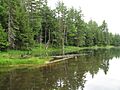
Catspaw Lake

See also
 In Spanish: Greig (Nueva York) para niños
