
Brian Head (mountain) facts for kids
Quick facts for kids Brian Head |
|
|---|---|

Brian Head Peak and Cedar Breaks
|
|
| Highest point | |
| Elevation | 11,312 ft (3,448 m) NAVD 88 |
| Prominence | 3,747 ft (1,142 m) |
| Listing | Utah county high points 15th |
| Geography | |

Brian Head
Location in Utah
|
|
| Location | Iron County, Utah, U.S. |
| Parent range | Markagunt Plateau |
| Topo map | USGS Brian Head |
Brian Head is a very tall mountain in southwestern Utah, United States. It stands at 11,312 feet (3,448 m) high. This makes it the highest point on the Markagunt Plateau. It is also the highest peak in Iron County. Brian Head Peak is located east of Cedar City. It is also just north of Cedar Breaks National Monument within the Dixie National Forest. At the western base of the mountain, you'll find the town of Brian Head. This town is home to the popular Brian Head Ski Resort.
Contents
Discover Brian Head Mountain
Why is it Called Brian Head?
Brian Head mountain got its name from a government surveyor. A surveyor is a person who measures and maps land. So, someone named Brian, who worked as a surveyor, helped map this area. The mountain was then named after him!
Getting to the Top of Brian Head
If you visit Brian Head, you can drive almost all the way to the summit. This is possible during the summer months. There is a special road that leads up the mountain. Near the very top, you will find a building called a Forest Service lookout. This lookout was built a long time ago, between 1934 and 1935. Forest Service lookouts are like observation towers. They were used to watch for wildfires to help protect the forest. Today, they still offer incredible views of the surrounding area!
Images for kids
-
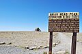
A sign at the very top of Brian Head Peak.
-
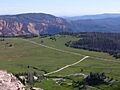
An amazing view looking out from the summit.
-
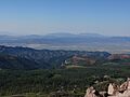
Another beautiful view, this time looking west from the top.
-
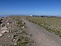
A trail near the summit of Brian Head Peak.


