
Brooks Island Regional Preserve facts for kids

The main portion of Brooks Island. At right is the start of the sandspit that extends about two miles west of the main island. Beyond the spit is the small rock of Bird Island.
|
|

Brooks Island Regional Preserve
Location in San Francisco Bay Area

Brooks Island Regional Preserve
Location in California

Brooks Island Regional Preserve
Location in the United States
|
|
| Geography | |
|---|---|
| Location | San Francisco Bay, Richmond, California |
| Coordinates | 37°53′47″N 122°21′19″W / 37.89639°N 122.35528°W |
| Adjacent bodies of water | Richmond Inner Harbor |
| Area | 75 acres (30 ha) |
| Length | 2 mi (3 km) |
| Width | 0.25 mi (0.4 km) |
| Highest elevation | 160 ft (49 m) |
| Highest point | Jefferds Peak |
| Administration | |
|
United States
|
|
| State | California |
| County | Contra Costa |
| City | Richmond, California |
| Administered by | East Bay Regional Park District |
| Demographics | |
| Population | 1 (2009) |
| Additional information | |
| Official website | http://www.ebparks.org/parks/brooks_island |
Brooks Island Regional Preserve is a special area in San Francisco Bay, near Richmond, California. It includes Brooks Island itself, which is about 75 acres, and 300 acres of the water around it. The island has a round hill called Jefferds Hill, which is about 160 feet tall.
The only way to visit Brooks Island is by joining a guided tour led by a park ranger. This helps protect the island's unique plants and animals. The island was bought by the park district in 1968 and opened to the public in 1988.
The island was first called Isla de Cármen by a Spanish explorer. Later, it appeared on maps as Brooks Island in 1853, but no one knows who "Brooks" was. It was also known as Sheep Island or Rocky Island at different times.
Contents
Island History: A Look Back in Time
Native American Life on Brooks Island
For thousands of years, Native American people, likely from the Ohlone tribe, lived on Brooks Island. They left behind large piles of shells and other remains called shellmounds. These shellmounds show that the island was a great place to find food from the bay, like mussels, oysters, clams, fish, and even seals.
Scientists have studied these shellmounds to learn about the people who lived there. They found tools like spear-throwers and harpoons made from bone. It seems the island was used for a very long time, possibly over 3,000 years ago, up until Europeans arrived.
Early European Settlers and Changes
In 1775, a Spanish explorer named Juan Manuel de Ayala mapped the island and named it Isla de Cármen. Later, in the 1800s, it became known as Brooks Island.
In 1870, a man named Luccas Gargurevich settled on the island and raised sheep and goats. He and his wife Dominica had nine children there! He even built a schoolroom and hired a teacher. Today, only a stone wall remains from their time on the island.
During the 1800s, people also started oyster farming in the waters near the island. There were even plans to build a railroad terminal there, but it never happened.
A quarry (a place where stone is dug out) opened on the island in 1892. For 46 years, stone was taken from the island, which is why it was sometimes called Rocky Island.
Brooks Island in the 20th Century
The quarry continued to operate in the early 1900s. Stone from Brooks Island was even used to help build parts of San Quentin State Prison.
During World War I, the United States Navy thought about leveling the island to build a huge dock for battleships, but they decided to build it somewhere else instead.
The island also had a shrimp processing factory for a while. In the 1920s, the United States Army Corps of Engineers used stone from the island's quarry to build a long wall, called a breakwater. This wall helped protect the Richmond Inner Harbor and keep the shipping channel deep. Over time, sand built up along this wall, creating the sandspit we see today.
After World War II, there were many ideas for the island. Some wanted to build a heliport (a place for helicopters) or industrial buildings. But others wanted to make it a public park.
In the 1960s, a group called the Sheep Island Gun Club leased the island. They brought in different kinds of birds like pheasants and quail for hunting. They even tried to bring deer, but the deer just swam back to the mainland!
Finally, in 1968, the East Bay Regional Park District bought most of the island. The City of Richmond bought the sandspit. This was a big step towards making it a park for everyone to enjoy.
Creating Brooks Island Regional Preserve
It took some time to plan the park. After many discussions, the island was officially named a "regional preserve." This means it's a special place meant to protect nature and history.
In 1985, a plan was made to stop hunting on the island and open it for limited public visits. The plan also included having a full-time caretaker live on the island to look after it. They also decided to protect Bird Island and the western end of the sandspit to keep bird nesting areas safe.
The island finally opened for limited public access in 1988, and guided tours began in 1991. Today, a caretaker lives on the island in a solar-powered cabin, helping to keep it clean and safe for wildlife.
Island Geography and Geology
.jpg)
Brooks Island is made of special rocks like chert, limestone, and sandstone. These rocks are part of a larger group called the Franciscan Assemblage, which also forms other hills in the area. These rocks formed millions of years ago from sediments (tiny bits of rock and sand) at the bottom of the sea.
The main part of the island is about 47 acres. There are also about 30 acres of tidal lands along the breakwater. A short distance from the main island is a tiny rock called Bird Island, which is about half an acre.
The long sandspit that stretches about two miles west of the main island formed along a breakwater built in the 1920s.
Thousands of years ago, during the last ice age, San Francisco Bay was a valley. Brooks Island was just a hill in that valley. As the ice melted and sea levels rose, the valley filled with water, and Brooks Island became an island. Even though it's small, it has a natural spring that provides water for the caretakers.
Island Ecology: Plants and Animals
Brooks Island is a home for many different plants and animals. It has salt marshes, tidal flats, and a hill that rises 160 feet. Many bird species live here, including herons and egrets, and they use the island for nesting. To protect these nesting sites, some parts of the island are off-limits to visitors.
Mammals on Brooks Island
Before Europeans arrived, there were no native land mammals on Brooks Island. Over time, animals like cattle, sheep, goats, and even mice and rats were brought to the island.
In 1957, scientists brought seven California voles (small rodents) to Bird Island. Soon, these voles crossed the water to Brooks Island and started to reproduce. Within two years, they had spread across the whole island and even replaced the house mice!
Brooks Island is also a resting spot for harbor seals. They often stop here on their way from a nearby place where they gather.
Reptiles, Amphibians, and Fish
When the sea level rose after the Ice Age, some salamanders and garter snakes got stuck on Brooks Island, and their descendants still live there today.
You can find three types of amphibians on the island: slender salamanders, arboreal salamanders, and Sierran chorus frogs.
There are also two types of western terrestrial garter snakes, some with red backgrounds and some with green. They eat other animals like northern alligator lizards, tree frogs, and small fish called mosquitofish that were brought to the ponds. Once, a western pond turtle was also seen here.
Birds of Brooks Island
More than 100 different kinds of birds have been seen on Brooks Island, and 18 species build their nests there.
Caspian Terns
Brooks Island has the largest nesting colony of Caspian terns in San Francisco Bay. These birds started nesting on the island around 1980. They use the long sandspit to build their nests. Terns eat fish from the bay. However, their numbers have been going down because their nesting areas are shrinking due to erosion and invasive plants. They also face competition from California gulls, which can steal their eggs and chicks.
Other Bird Species
.jpg)
Many other birds use Brooks Island. The northeast shore is home to a large group of herons and egrets during nesting season.
Bird Island, just west of Brooks Island, is a nesting site for Canada geese, black oystercatchers, and western gulls.
Insects on the Island
Brooks Island has many native plants, which provide a great home for insects. Scientists found that 10% of the 220 moth and butterfly species on the island were either new to the San Francisco Bay area or hadn't been seen in 50 to 100 years! This included the Mexican tiger moth.
Island Plants (Flora)
Because Brooks Island hasn't been changed much by people, it has many rare plant communities that are hard to find elsewhere in the East Bay.
The most common plant types are coastal grassland and northern coastal scrub. The grassland areas are special because they have many native wildflowers like blue dicks, soap plant, and checker mallow, instead of non-native grasses.
Another special plant is the seaside woolly sunflower, which only grows in a few other places in the East Bay.
Overall, the island has about 150 types of flowering plants, and 92 of them are native to the area.
There are not many trees on the island. You can find a few California buckeyes, a red willow, and some blue elderberry trees. Near the old quarry, there are some arroyo willows. A few non-native Monterey pines and Monterey cypress trees have also been planted near the caretaker's home.
Images for kids
-
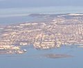
Brooks Island, viewed from the south, in an aerial photo from 2018
.jpg)
See also
 In Spanish: Isla Brooks para niños
