Bryan Mountains facts for kids
Quick facts for kids Bryan Mountains |
|
|---|---|
| Highest point | |
| Peak | Unnamed |
| Elevation | 1,794 ft (547 m) |
| Dimensions | |
| Length | 10 mi (16 km) NW-SE |
| Width | 3 mi (4.8 km) |
| Geography | |
| Country | United States |
| State | Arizona |
| Region | (northwest)-Sonoran Desert |
| District | Yuma County |
| Settlement | Mohawk, Arizona–Ajo, Arizona |
| Range coordinates | 32°18′27″N 113°22′46″W / 32.30750°N 113.37944°W |
| Borders on | Mohawk Mountains-NNW Granite Mtns-E Mohawk Valley-SW Sierra Pinta and Tule Desert-SW |
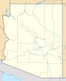
The Bryan Mountains are a small mountain range found in the northwestern part of the Sonoran Desert in southwestern Arizona. This mountain range is located in southeastern Yuma County. It's about 75 miles (120 km) southeast of the city of Yuma and about 35 miles (56 km) west of Ajo.
The Bryan Mountains are about 10 miles (16 km) long. At their widest point, they stretch about 3 miles (5 km) across. The highest spot in the range is 1,794 feet (547 meters) above sea level. The entire mountain range is located inside the Cabeza Prieta National Wildlife Refuge. This refuge helps protect the desert's plants and animals.
Geologists believe the Bryan Mountains are a natural extension of the Mohawk Mountains. These mountains were formed by a process called block faulting. This is when large blocks of the Earth's crust move up or down along cracks called faults. For a long time, even into the mid-1900s, the Bryan Mountains were considered part of the larger Mohawk Mountains.
Contents
Discovering the Bryan Mountains
How the Mountains Got Their Name
The Bryan Mountains were named in 1933 by a person named Eldred D. Wilson. He named them after Kirk Bryan. Kirk Bryan was a geologist and explorer who worked for the U.S. Geological Survey (USGS).
In the early 1920s, Kirk Bryan explored this area. He wrote a detailed guide about the geology of the region. He also described where to find water, which was very important in the dry desert.
Early Explorers of the Desert
Kirk Bryan was one of many geologists and geographers sent by the USGS. Their job was to explore and record information about the dry southwestern United States. They wanted to understand the physical features of these desert lands.
The reports published by Bryan and others are very important today. They show what the Sonoran Desert and Mojave Desert were like. This was before many people moved to the region after World War II. Their work helps us understand how much the area has changed.
Mapping the Mountains
When Eldred D. Wilson named the mountains, he thought they were bigger. On his 1933 map of Yuma County, he showed the Bryan Mountains extending further. He included what is now the southern part of the Mohawk Mountains. He also included some hills to the south and southwest.
However, later maps showed a smaller version of the range. Surveyors from the Army Map Service and the USGS made the first detailed maps in the mid-1960s. For reasons that are not fully clear, they drew the Bryan Mountains as they appear on maps today. This smaller depiction has been used on all modern USGS maps.
 | Janet Taylor Pickett |
 | Synthia Saint James |
 | Howardena Pindell |
 | Faith Ringgold |


