Bryn Mawr, Minneapolis facts for kids
Quick facts for kids
Bryn Mawr
|
|
|---|---|
|
Neighborhood
|
|

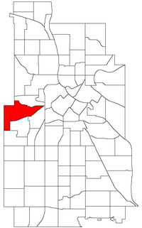
Location of Bryn Mawr within the U.S. city of Minneapolis
|
|
| Country | United States |
| State | Minnesota |
| County | Hennepin |
| City | Minneapolis |
| Community | Calhoun-Isles |
| City Council Ward | 7 |
| Area | |
| • Total | 1.348 sq mi (3.49 km2) |
| Population
(2020)
|
|
| • Total | 2,768 |
| • Density | 2,053.4/sq mi (792.8/km2) |
| Time zone | UTC-6 (CST) |
| • Summer (DST) | UTC-5 (CDT) |
| ZIP code |
55405, 55416
|
| Area code(s) | 612 |
| Historical population | |||
|---|---|---|---|
| Census | Pop. | %± | |
| 1980 | 2,777 | — | |
| 1990 | 2,845 | 2.4% | |
| 2000 | 2,663 | −6.4% | |
| 2010 | 2,651 | −0.5% | |
| 2020 | 2,768 | 4.4% | |
Bryn Mawr is a friendly neighborhood in Minneapolis, Minnesota. Its name comes from a Welsh phrase meaning "big hill." This area is located just west of downtown Minneapolis.
Bryn Mawr is part of the Calhoun-Isles community. It is in Ward 7, and Katie Cashman is the current council member for this area.
Before the 1960s, many people who worked for the nearby Minneapolis and St. Louis Railway lived here. Today, Bryn Mawr is mostly a residential area. It has two small groups of businesses.
The neighborhood is surrounded by lots of green spaces. To the west and northwest, you'll find Theodore Wirth Park. To the south, there's Cedar Lake and Cedar Lake Park. Bassett Creek is to the north, and Bryn Mawr Meadows park is to the east.
Contents
Who Lives in Bryn Mawr?
In 2020, about 2,768 people lived in Bryn Mawr. Slightly more than half of the residents were female. Almost everyone living here had finished high school. Many residents, about 7 out of 10, had also earned a college degree.
Most people in Bryn Mawr own their homes. Only a small number of households did not have access to a car. Most workers, about 75%, drove to their jobs. About 22% of people walked, biked, or worked from home.
Population by Background
Here's a look at the different groups of people living in Bryn Mawr in 2020:
| Group | Share of total population (2020) |
|---|---|
| Total | 100% |
| One race | 94.4% |
| White | 84.5% |
| Black or African American | 3.3% |
| American Indian and Alaska Natives | 0.1% |
| Asian | 2.6% |
| Hispanic | 3.6% |
| Native Hawaiian and Other Pacific Islander | <0.1% |
| Other | 0.4% |
| Two or more races | 5.6% |
Fun Events in Bryn Mawr
Bryn Mawr hosts several community events throughout the year:
Bryn Mawr Festival of Garage Sales
This big event started in the 1970s. It features over 100 garage sales! You can also find food and drinks. People from all over the Twin Cities area come to this festival. It happens on the first full weekend in May.
Bryn Mawr Ice Cream Social
The Bryn Mawr Neighborhood Association hosts this annual event. Neighbors get together to socialize. They also vote for their favorite ice cream flavors.
Sip and Stroll
Local businesses in Bryn Mawr sponsor this event every October. Neighbors can visit different restaurants and stores in the area.
Bryn Mawr News
The neighborhood has its own newspaper called the Bryn Mawr Bugle. It comes out every month, except for January.
Schools in Bryn Mawr
Bryn Mawr has two schools that are part of Minneapolis Public Schools. Both are located near Theodore Wirth Park.
- Bryn Mawr Elementary School: This school is for younger students, from pre-kindergarten to 5th grade.
- Anwatin Middle School: This school serves students in grades 6 through 8.
After middle school, students from Bryn Mawr usually attend North High School for grades 9 through 12.
 | Tommie Smith |
 | Simone Manuel |
 | Shani Davis |
 | Simone Biles |
 | Alice Coachman |

