Buena Vista Valley facts for kids
Quick facts for kids Buena Vista Valley |
|
|---|---|
| Length | 40 mi (64 km) N-S |
| Geography | |
| Country | United States |
| State | Nevada |
| Region | Great Basin |
| County | Pershing |
| Communities | Unionville, Mill City and Fitting (site) |
| Borders on | Humboldt Range, East Range, Stillwater Range and Carson Sink |
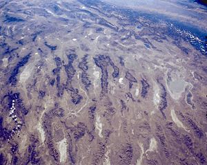
The Buena Vista Valley is a long valley in central-east Pershing County, Nevada. It stretches for about 40 miles (64 km). The town of Unionville is located at the northwest end of the valley. It sits at the base of the Humboldt Range mountains.
Inside the valley, you'll find the Buena Vista Lake Bed. This dry lake bed is shaped like a crescent moon. It is about 18 miles (29 km) long and sits next to the southeast side of the Humboldt Range.
What is the Buena Vista Valley Like?
The Buena Vista Valley runs mostly from north to south. It has a crescent shape, meaning it curves. The valley gets narrower at its northern end and also towards its southwest end.
In the north, the valley narrows because of the mountains around it. The Humboldt Range is to the west, and the East Range is to the east. The widest part of the valley is near the northern end of the Buena Vista Lake Bed, where it is about 13 miles (21 km) wide.
The southwest part of the valley connects to the northwest side of the Carson Sink. The valley narrows here because of the Stillwater Range. This mountain range turns towards the northeast in its northern section.
There are also some low hills in this area. These include the Buena Vista Hills, which are about 5,220 feet (1,591 m) high, and Chocolate Butte, about 4,778 feet (1,456 m) high. These hills are between the Carson Sink and the southwest part of Buena Vista Valley. This hilly area is sometimes called "Antelope Valley."
How to Get to Buena Vista Valley
You can reach the southern part of Buena Vista Valley from the west. Take Interstate 80 north of Lovelock. Then, turn onto Coal Canyon Road. This road is paved all the way to the southern end of the valley.

To get to the northern part of the valley, use Nevada State Route 400. This road goes south from Mill City, which is also on Interstate 80. It leads to Unionville, located at the western base of the Humboldt Range. Many unpaved roads also run through all parts of the valley.
See also
 In Spanish: Valle Buena Vista para niños
 | Charles R. Drew |
 | Benjamin Banneker |
 | Jane C. Wright |
 | Roger Arliner Young |


