Burghead Fort facts for kids

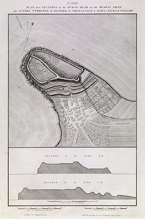
Plan of the remains of the fort drawn by General William Roy in 1793
|
|
| Coordinates | 57°42′13″N 3°29′50″W / 57.7036°N 3.4971°W |
|---|---|
| Type | Promontory fort |
| Length | 1,000 feet (300 m) |
| Width | 600 feet (180 m) |
| Area | 12.4 acres (5.0 ha) |
| History | |
| Periods | Iron Age, Pictish |
Burghead Fort was a huge Pictish fort built on a piece of land sticking out into the sea, called a promontory fort. It was located where the town of Burghead in Moray, Scotland is today. This fort was one of the most important places for the Picts, an ancient people of Scotland.
It was three times bigger than any other enclosed site in early medieval Scotland. Burghead Fort was likely the main centre of the Pictish Kingdom of Fortriu. It was a powerful place from the 4th to the 9th centuries.
We don't have any old records that mention Burghead Fort by name. Its Pictish name is unknown. However, it might be the Pinnata Castra mentioned in Ptolemy's Geography from the 2nd century. The first walls might have been built during the Iron Age, but they were greatly rebuilt later.
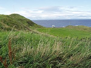
Sadly, most of the fort was destroyed in the early 1800s. This happened when the harbour and town of Burghead were changed. But we know what it looked like thanks to a plan drawn by William Roy in 1793. Some parts of its inner walls still stand up to 9.8 feet (3.0 m) high. A small piece of the outer wall is known as the "Doorie Hill".
You can still visit the fort's underground well today. There is also a visitor centre. Here, you can see important Pictish stone carvings found at the fort.
Contents
What did Burghead Fort look like?
The fort had a large walled area. It was about 1,000 feet (300 m) long and 600 feet (180 m) wide. This area was split into two parts. There was a smaller, higher section to the southwest. This was like a strong castle or citadel. The other part was larger and lower, to the northeast.
In total, the fort covered an area of 12.4 acres (5.0 ha). To protect the fort from the mainland, there were three ramparts (earth walls) and ditches. These measured about 800 feet (240 m) by 180 feet (55 m). Each had an entrance in the middle. They were made of earth and rocks. Digging in the 1890s showed a paved road going through the fort.
How were the walls built?
In 1969, people dug up the western wall of the higher part of the fort. They found it was incredibly strong. The base was 8 metres (26 ft) thick, and it still stood 3 metres (9.8 ft) high. The wall would have been even taller, perhaps up to 6 metres (20 ft) high. It might have even had wooden structures on top.
The walls were built with stone layers on the front and back. These layers held a framework of wooden beams inside. The space in the middle was filled with stones and pebbles. The foundations of the walls were made of oak wood laid on sand. The oak beams likely stuck out from the stone walls.
The stone walls of the lower part of the fort also had a wooden framework. But these were held together by huge iron spikes! This was a very unusual building method. It was not like earlier British Iron Age forts. Instead, it was similar to strong forts found in Europe from the late La Tene period.
History of Burghead Fort
Burghead Fort was built in several stages. Scientists used Radiocarbon dating to find out when the main walls were built. They were constructed in the early historic period, possibly as early as the late 3rd century. They were repaired and made stronger in the 6th or 7th centuries.
The way the fort was designed was common for forts built across Britain and France in the late Iron Age. This suggests that the Picts might have taken over an older stronghold. Then they made it much stronger by adding stone walls. The different building styles in the upper and lower parts of the fort suggest they were built at different times.
The three ramparts and ditches that separated the fort from the land might be even older. They could be Iron Age defences. Other signs of earlier life at the fort include a Late Bronze Age spearhead. A Greek coin from the time of Nero (54–68 AD) was also found. A Celtic stone head was discovered inside the well.
There are signs that people lived and worked here during the Iron Age, Norse, and Early Medieval times. But after the 9th century, there are no signs of anyone living in the fort. This time matches when the Annals of Ulster recorded terrible Norse raids on the Kingdom of Fortriu.
What was the fort used for?
The two main parts of the fort had separate entrances. There was no gate between them. This suggests that one part was more important than the other. The higher part of the fort to the west was likely for important people. It may have had a royal hall and homes for the ruler.
The larger area to the northeast probably held a settlement. This higher part would also have had buildings for the ruler's guards and people who supplied the royal court. Building foundations have been found in the lower area. There is also proof that animals were kept within the outer walls.
Burghead's importance and its excellent nearby harbour mean it was probably a key base for the Pictish navy. The Pictish navy was very strong between the 4th and 8th centuries.
Religious importance
The fort was important for religion too. Stone carvings of bulls found in the 1800s suggest that people might have worshipped bulls. The underground well, with its rock-cut chamber, might have been a centre for worshipping water. This idea is supported by the Celtic stone head found in the well.
The Burning of the Clavie is a fire festival that still happens in Burghead every year. Some people think it is a very old pagan fire festival that has survived. By the 8th century, there is proof of a chapel inside the fort. Decorated stones from around AD 800 found in Burghead churchyard were likely parts of Christian crosses.
Pieces of an early Christian shrine have been found just outside the fort. The fort's power centre may have had a strong connection with major Pictish religious sites. These include Kinneddar, about 8 miles (13 km) to the east, and Portmahomack. Portmahomack can be seen from Burghead across the Moray Firth.
The Burghead Bulls

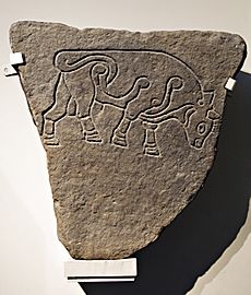
When the fort was being destroyed in the early 1800s, many stone panels were found. These panels had carved images of bulls. Up to thirty of these bull carvings were discovered. Most of them were used to build the quay wall of Burghead Harbour and were lost.
However, six of these amazing bull carvings still exist today. Two are in the visitor centre in Burghead. Two are in Elgin Museum. One is in the National Museum of Scotland in Edinburgh. And one is in the British Museum in London.
These Bulls are thought to be from the 5th century or later. They might have been part of a frieze (a long band of sculpted decoration) set into the fort's walls. They could have been part of a warrior cult, celebrating strength and power.
The Burghead Bulls look very realistic. This level of detail is rare in early Medieval art. The carvings show how important Burghead Fort was. They suggest it was a very important Royal centre in early times.
 | Sharif Bey |
 | Hale Woodruff |
 | Richmond Barthé |
 | Purvis Young |


