Burnley Embankment facts for kids
Quick facts for kids Burnley Embankment |
|
|---|---|
| Coordinates | 53°47′19″N 2°14′15″W / 53.78861°N 2.23750°W |
| OS grid reference | |
| Carries | Leeds and Liverpool Canal |
| Crosses | Calder valley, Brun valley, Yorkshire Street |
| Locale | Burnley, Lancashire, England |
| Maintained by | Canal & River Trust |
| Heritage status | Grade II listed (partial) |
| Characteristics | |
| Material | Soil (embankment) Stone (Calder aqueduct) Sandstone (retaining walls) |
| Total length | 1,256 yd (1,148 m) |
| Height | 60 ft (18 m) |
| Traversable? | Yes |
| Towpaths | W |
| History | |
| Designer | Robert Whitworth |
| Construction begin | 1796 |
| Construction end | 1801 |
| Lua error in Module:Location_map at line 420: attempt to index field 'wikibase' (a nil value). | |
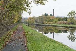
The Burnley Embankment is a massive earth wall that carries the Leeds and Liverpool Canal high above the Calder and Brun valleys in Burnley, Lancashire. It is also known as the Straight Mile because it is so long and straight. This amazing structure is about 1,256 yards (or 1.15 kilometers) long. The canal on top of it runs as high as 60 feet (about 18 meters) above the ground below. The Burnley Embankment is considered one of the original Seven Wonders of the Waterways in Britain. It has also received a special "Red Wheel" award from the Transport Trust, which celebrates important transport landmarks.
Contents
Why the Embankment Was Built
Building the Leeds and Liverpool Canal started way back in 1770. However, work had to stop for a while during the American War of Independence because there wasn't enough money. This left two separate parts of the canal, one from Leeds and one from Liverpool.
The first plan for the canal was to go north of the River Calder in Burnley. It would have crossed the river at a place called Whalley using a special bridge for boats, called an aqueduct. Burnley would have had a smaller branch canal connecting to it.
But before work started again in 1790, the canal builders decided to change the route. They got permission to move the canal further south. This new path would cross the river between Filly Close and Ightenhill. By 1794, the route was changed again, moving even further south.
The River Calder and another river called the Brun meet in a wide valley in Burnley. The canal builders thought about crossing the Calder even further up the valley. However, the powerful Towneley family didn't want the canal to come too close to their home, Towneley Hall. So, the current route, which includes the huge embankment, was chosen instead.
How the Embankment Was Built
The Burnley Embankment was built between 1796 and 1801. It was a way to avoid building many locks (steps for boats to go up and down) on both sides of the valley.
The embankment was designed by Robert Whitworth. He was in charge of the building work until he passed away in 1799. After him, Samuel Fletcher took over. Building this massive structure cost about £22,000 at the time, which would be around £1.6 million today!
The builders used a huge amount of earth – about 350,000 cubic yards (or 267,000 cubic meters) of soil. Much of this soil came from digging the nearby Gannow Tunnel, which is 559 yards long, and a large trench called the Whittlefield cutting.
The embankment is 1,256 yards (1.15 km) long and runs roughly north to south. The path for horses and people, called the towpath, is on the western side.
At the northern end of the embankment, the canal crosses the River Brun on a bridge called the Sandy Holme Aqueduct. A road called Godley Lane had to be moved to meet the new bridge there. At the southern end, there was once a farm called Finsley. When the canal arrived, it became a busy wharf (a place for loading and unloading boats) and a repair yard.
Crossing Roads and Rivers
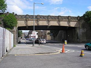
About halfway along the embankment, the canal crosses Yorkshire Street. This crossing is known as "The Culvert." Even though it's called a culvert, it's actually an aqueduct because it carries water over a road.
When it was first built in 1797, The Culvert was a single archway shaped like a horseshoe. It was 70 feet (21 meters) long and 14 feet (4.3 meters) high above the road.
On the east side of the embankment, just north of Yorkshire Street, there are four lime kilns. These were built at the same time as the embankment. Two more kilns on the west side were used to make lime for building and clay to seal the canal.
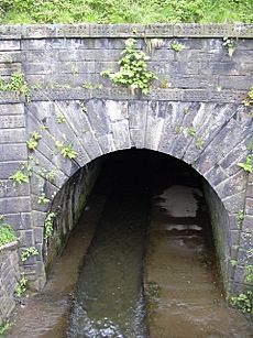
The aqueduct that carries the canal over the River Calder is closer to the southern end. It was built between 1795 and 1796. This aqueduct looks similar to the original road crossing. It has a single, rounded arch with special wedge-shaped stones called voussoirs. There are also decorative pillars on either side of the arch. Many of the stone blocks are carved with a wavy pattern.
It took a long time for the embankment to settle and become strong enough to hold water. But once it was ready, the canal opened up to Clayton-le-Moors in 1801.
How the Embankment Was Used
Burnley was a big coal mining area, and the canal was built through the town to help transport the coal. In the early 1800s, a coal mine called Fulledge Colliery was connected to the canal by a special railway for wagons. Another mine, the Burnley Drift, went underneath the southern end of the embankment.
Once, a mine owned by Rev. Hargreaves caused a big part of the embankment to collapse because they dug coal directly underneath it. The Calder aqueduct had to be partly rebuilt after this. There was also a small dock at the southern end for loading coal.
Later in the 1800s, older coal mines closed down. But the embankment continued to be used by coal workers. The old coal dock was filled in and replaced by a larger coal yard. This new yard was connected to Towneley Colliery.
The cotton industry also grew very fast in Burnley after 1780. Many factories were built near the embankment in the early 1800s. Some of the earliest factories were Scar Top Mill, Hill Top Mill, and Rishton Mill. Later, Hill Top and Rishton mills were even expanded up the embankment so they could easily access the canal's towpath.
By the early 1900s, twelve mills were operating right next to the embankment. Most of these were textile mills. The canal was very important for them because, from the 1840s, mill owners were allowed to take water from the canal to power their machines. The embankment, holding the canal 60 feet above the mills, provided a perfect "head of water" (a high point for water to flow down from). Special gates were built to control how much water was taken.
Other businesses also used the embankment. Three corn mills (mills that ground grain) were built on the western side by 1851. The last corn mill in Burnley, Pilling Field Mill, closed in 1912.
How it Changed Burnley
The canal embankment greatly shaped how Burnley grew. When it was built, the embankment was on the edge of the town, going through open fields. But Burnley quickly became a busy port on the canal. The town grew rapidly in the 1800s, with its population doubling in just 20 years! Land near the canal was used for houses, cotton mills, warehouses, and wharves.
Even though the canal helped Burnley grow, the embankment also became a physical barrier. It made it harder for the town to expand towards the east. By 1851, the western side of the embankment was full of buildings. But on the eastern side, there was only a small area around St Mary's Church.
Over time, changes were made to help people cross the embankment. In 1878, Godley Lane was closed and replaced by Ormerod Road. In 1885, the swing bridge at Finsley Gate was replaced with a fixed bridge.
In 1896, two small tunnels were added to The Culvert (the aqueduct over Yorkshire Street). These were called "gimlet holes" and allowed people to walk under the embankment without using the main arch.
The entire Culvert was rebuilt in 1926 and 1927. It was made taller and wider to handle more traffic, including the new tramways and double-decker buses. The old structure and the pedestrian tunnels were no longer big enough.
On the aqueduct, there is a crane. This crane is used to move special wooden planks called "stop planks." These planks can temporarily block the canal to drain sections for maintenance and repairs.
What Makes it Special Today
In 1997, the aqueduct over the River Calder, which is part of the embankment, was given Grade II listed status. This means it is an important historical building that must be protected. The four lime kilns near The Culvert also received the same status at the same time.
In June 2012, the Transport Trust placed a "Red Wheel" plaque at the embankment. This plaque celebrates the amazing engineering of the waterway. It proudly states that the Burnley Embankment is the "largest canal embankment in Britain."
 | James Van Der Zee |
 | Alma Thomas |
 | Ellis Wilson |
 | Margaret Taylor-Burroughs |


