Burrard Peninsula facts for kids
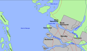
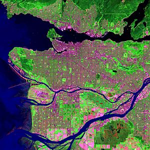
The Burrard Peninsula (also called Squamish: Ulksen by the Squamish people) is a piece of land in southwestern British Columbia, Canada. It's like a big finger of land pointing west. To its north is the Burrard Inlet, and to its south is the Fraser River. The Strait of Georgia is to its west, and the Pitt River is to its east. The big city of Vancouver covers most of the western part of this peninsula.
The Squamish name for this area, especially the land from West Point Grey to Central Park, was Ulksen. Most people who live here don't usually say 'Burrard Peninsula'. Instead, they refer to specific towns or neighborhoods within it.
Contents
How Big Is the Burrard Peninsula?
It's a bit tricky to say exactly where the Burrard Peninsula begins and ends. This is because it's not an official place in government records. It doesn't have a legal boundary.
However, it connects to the mainland at its northeastern end. We can imagine its "neck" or narrowest part follows the main Canadian Pacific Railway (CPR) tracks. This goes from Port Moody (at the east end of Burrard Inlet) through Coquitlam and Port Coquitlam to the Pitt River.
From where the CPR tracks cross the Pitt River, the peninsula stretches west for about 40 kilometers (25 miles). It ends at Point Grey, a piece of land sticking out into the Strait of Georgia. For most of its length, the peninsula is about 6 to 8 kilometers (4 to 5 miles) wide.
Cities and Towns on the Peninsula
Many cities and towns are located on the Burrard Peninsula. If you travel from west to east, you'll find:
- The City of Vancouver
- The City of Burnaby
- The City of New Westminster
- The City of Port Moody
- The City of Coquitlam
- The City of Port Coquitlam
At the very western end of the peninsula, at Point Grey, are the University Endowment Lands. This is where the main campus of the University of British Columbia is located. These lands are not part of any city.
Just north of the peninsula's "neck" are the villages of Belcarra and Anmore. While they aren't directly on the peninsula, you can only reach them by road through the Burrard Peninsula.
What the Land Looks Like
The Burrard Peninsula is mostly a hilly area, like a plateau. In most places, it rises between 100 and 150 meters (300 and 500 feet) above sea level.
This plateau is cut through by a low valley that runs from northwest to southeast. This valley includes:
- False Creek: This separates the main peninsula from Downtown Vancouver. Downtown Vancouver is actually on its own smaller peninsula, sometimes called "Coal Peninsula."
- Railway Yards: These are built on land that was once water, at the east end of False Creek. They are used by the Canadian National Railway (CN) and the Burlington Northern Santa Fe (BNSF) railways.
- The Grandview Cut: This is a trench that holds tracks for both the CN/BNSF railways and the SkyTrain.
- Still Creek: This creek flows into Burnaby Lake.
- Burnaby Lake: This lake then drains into the Brunette River.
- The Brunette River: This is the last major river that flows into the Fraser River before it reaches the ocean. It joins the Fraser River at New Westminster.
There are also some higher points on the plateau:
- Little Mountain in Vancouver: This is an old volcano, about 170 meters (560 feet) above sea level.
- Capitol Hill in Burnaby: About 220 meters (720 feet) high.
- Burnaby Mountain in Burnaby: Home to Simon Fraser University, it's about 380 meters (1,250 feet) high.
At the eastern end of the plateau is the Coquitlam River. This river flows south from Coquitlam Lake on the mainland into the Fraser River. The land east of the Coquitlam River is mostly flat and close to sea level, except for Mary Hill in Port Coquitlam, which is about 70 meters (230 feet) high.
How the Land is Used
The Burrard Peninsula is very developed, with many buildings and people. It has the largest and most crowded populations in the Metro Vancouver area and in British Columbia.
This area was once covered in thick forests. But since the mid-1800s, it has slowly become one big city. Even so, there are still some large green spaces left for nature and recreation:
- Pacific Spirit Regional Park in Point Grey
- Stanley Park in Downtown Vancouver
- Areas around Burnaby Mountain
- Central Park in Burnaby
- Burnaby Lake and Deer Lake in Burnaby
- Mundy Park and the Coquitlam River in Coquitlam
 | Leon Lynch |
 | Milton P. Webster |
 | Ferdinand Smith |


