Burrow (Shropshire) facts for kids
Quick facts for kids Burrow |
|
|---|---|

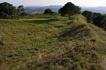
South-west corner of the hill fort
|
|
| Highest point | |
| Elevation | 358 m (1175 ft) |
| Prominence | c. 189 m |
| Parent peak | Pegwn Mawr |
| Listing | Marilyn |
| Geography | |
| Location | Shropshire, England |
| Parent range | Shropshire Hills |
| Topo map | OS Landranger 137 |
Burrow is a special hill located in Shropshire, England. At the very top of Burrow, you'll find an ancient place called Burrow Camp. This camp is actually an Iron Age hill fort, which was like a fortified village or stronghold from a very long time ago. The closest villages to Burrow are Hopesay and Aston-on-Clun.
Contents
What is Burrow?
Burrow is a significant hill in the Shropshire Hills range. It stands tall at about 358 meters (or 1,175 feet) above sea level. From its top, you can see amazing views of the surrounding countryside. It's known as a "Marilyn," which is a special term for a hill in Britain or Ireland that is at least 150 meters (about 492 feet) higher than the land around it.
The Iron Age Hill Fort
Burrow Camp is an Iron Age hill fort. The Iron Age was a period in history that lasted from about 800 BC to AD 100 in Britain. During this time, people learned to use iron to make tools and weapons. Hill forts were very common during the Iron Age. They were usually built on high ground, like Burrow, to give people a good view of anyone approaching. This helped them defend themselves from enemies.
Life at Burrow Camp
People who lived in hill forts like Burrow Camp were often farmers. They would have grown crops and raised animals. The fort would have had strong walls, often made of earth and wood, to protect the community inside. It was a safe place for families to live and store their food and belongings. Life in the Iron Age could be tough, so these forts were very important for survival and safety.
Why were Springs Important?
One of the most interesting things about Burrow Camp is that it has two natural springs. Springs are places where water naturally flows out of the ground. For people living in the Iron Age, having a reliable source of fresh water was incredibly important. It meant they didn't have to leave the safety of the fort to get water, which was a huge advantage, especially during times of conflict. This might be why Burrow was such an important place during the Iron Age.
Where is Burrow?
Burrow is located in the county of Shropshire, which is in the west of England. It's part of the beautiful Shropshire Hills, an area known for its stunning landscapes and rich history. The hill is a popular spot for walkers and people who enjoy exploring ancient sites.
 | Jackie Robinson |
 | Jack Johnson |
 | Althea Gibson |
 | Arthur Ashe |
 | Muhammad Ali |

