Buss Island facts for kids
Quick facts for kids Buss Island |
|
|---|---|

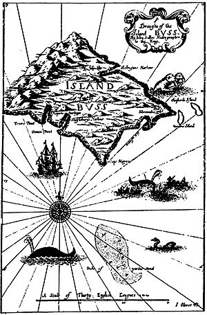
Buss Island map from John Seller's "English Pilot"
|
|
| Created by | Martin Frobisher |
| Type | Phantom island |
Buss Island was a mysterious "phantom island" that appeared on old maps of the North Atlantic Ocean. A phantom island is a piece of land that explorers thought they saw, or that was mistakenly put on maps, but actually doesn't exist. For many years, people believed Buss Island was real, located somewhere between Ireland and a mythical land called Frisland.
The story of Buss Island began in September 1578. Sailors on a ship called the Emanuel (which was a type of vessel known as a "busse") reported seeing this new land during the third expedition of Martin Frobisher. The island was then named after their ship type. However, it's now thought that the crew might have made a mistake in their navigation or seen optical illusions, like mirages, near Greenland. They might have confused Greenland with Frisland and Baffin Island with Greenland!
Over time, as more ships sailed the Atlantic, people started to doubt if Buss Island truly existed. By 1745, it was clear there was no island there, so it was renamed the Sunken Land of Buss. This new name suggested that perhaps an island had once been there but had sunk, or that the area was just unusually shallow. Even after this, the "Sunken Land" still appeared on some maps for many more years. Finally, in 1818, explorer John Ross proved once and for all that Buss Island was not real during his Arctic expedition. He searched the area and found no land, only deep ocean.
Contents
The Mystery of Buss Island: A Phantom on the Map
The "Discovery" by Martin Frobisher's Crew
In 1578, the famous English explorer Martin Frobisher led his third journey to the Arctic. His goal was to find the Northwest Passage, a sea route connecting the Atlantic and Pacific Oceans. During this expedition, one of his ships, the Emanuel, was sailing home. The sailors on board reported seeing a new island in the vast North Atlantic. They named it "Buss Island" after their ship, which was a "busse" – a type of sturdy sailing vessel.
This new island quickly appeared on maps of the time. It was usually shown north of Ireland, near a legendary land called Frisland. Today, historians believe the crew of the Emanuel likely made a mistake. They might have miscalculated their position using a method called "dead reckoning," which involves estimating your location based on speed and direction. It's also possible they saw optical illusions, like strange reflections or mirages, caused by the cold Arctic air and water, making distant ice or land look like a new island. Some even think they might have confused Greenland for Frisland and Baffin Island for Greenland!
Doubts Grow: From Island to "Sunken Land"
For many years, Buss Island remained on maps, a testament to the early explorers' reports. However, as more and more ships began to cross the Atlantic Ocean for trade and exploration, sailors started to question its existence. Many tried to find it but failed.
One person named Thomas Shepard claimed to have explored and mapped the island in 1671 from his ship, the Golden Lion. But as time went on, the island's supposed size on maps began to shrink, reflecting the growing doubts. By 1745, it became clear to mapmakers that there was no island at the reported location. Instead of simply removing it, they changed its name to the Sunken Land of Buss. This new name suggested that perhaps an island had once existed there but had somehow sunk beneath the waves, or that the area was just a shallow part of the ocean.
The Final Proof: John Ross Disproves Buss Island
Even as the "Sunken Land of Buss," this phantom location continued to appear on some sea charts well into the 19th century. It was important for navigators to know if there were any hidden dangers or shallow areas.
The final answer came in 1818, thanks to the British explorer John Ross. During his first Arctic expedition aboard the ship Isabella, Ross specifically sailed to the coordinates where Buss Island was supposed to be. He used advanced sounding equipment to measure the depth of the ocean. Ross found no land and no shallow area; the water was incredibly deep, over 180 fathoms (which is about 180 fathoms (330 m)). His findings proved conclusively that Buss Island, whether as a visible landmass or a sunken area, simply did not exist. This marked the end of Buss Island's long journey from a reported discovery to a confirmed myth on maps.
See also
- Azores (real island group in the mid-atlantic)
 | Dorothy Vaughan |
 | Charles Henry Turner |
 | Hildrus Poindexter |
 | Henry Cecil McBay |


