Frisland facts for kids

Frisland was a mysterious "phantom island" that appeared on many maps of the North Atlantic Ocean for about 100 years. It was also known by names like Frischlant, Friesland, Frislanda, Frislandia, or Fixland. A phantom island is a piece of land that mapmakers believed existed but was later found not to be real.
Frisland was shown on almost all maps from the 1560s to the 1660s. It was eventually removed from maps as explorers charted the oceans more carefully. In those days, navigation was much harder without modern tools like accurate marine chronometers. Some historians think Frisland might have been a mistake, perhaps a misidentification of Iceland or Greenland.
Contents
The Mystery of Frisland: A Phantom Island
How Frisland Appeared on Maps
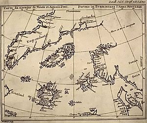
The story of Frisland began in 1558. A man named Nicolò Zen the younger published some old letters and a map. He claimed these documents described a journey made by his ancestors, Nicolò and Antonio Zeno, in the 1390s. These brothers supposedly explored the northern Atlantic and discovered several islands, including Frisland. Nicolò Zen the younger said he found these old papers in his family's home in Venice.
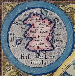
After this publication, famous mapmakers started adding Frisland to their own maps. Gerardus Mercator included it as "Frislant" on his important 1569 world map. Abraham Ortelius also showed it in his 1570 atlas. Even though some maps, like an early one by Willem Blaeu in 1617, left it out, Frisland often reappeared. For example, Blaeu's 1630 world map showed it near the eastern coast of Labrador. Another map by Claes Jansz. Visscher in 1652 also featured Frisland.
Frisland's Disappearance from Maps
Over time, explorers, especially from England and France, began to map the North Atlantic more accurately. They sailed through the areas where Frisland was supposed to be, but they never found it.
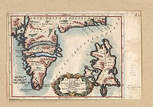
By 1693, the mapmaker Vincenzo Coronelli placed Frisland close to Greenland. However, he added a note saying it was "believed to be a fable, or submerged in the sea." This shows that people were starting to doubt its existence. Even in the mid-1700s, some maps still showed Frisland. But as navigation and exploration improved, the myth of Frisland slowly faded away. It was eventually removed from all new maps because it simply wasn't there.
What Did Frisland Look Like on Maps?
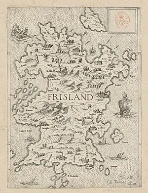
On maps, Frisland was usually drawn as a roughly rectangular island. It often had three triangular points sticking out from its western coast. Sometimes, it was also called "Fixland" on older maps.
Other Mysterious Islands
Frisland is not the only island that appeared on old maps but was later found to be imaginary. These "phantom islands" tell us a lot about how people explored and understood the world long ago.
- Buss Island: Another phantom island that appeared on maps of the mid-Atlantic from the late 1500s to the early 1800s.
- Estotiland: This was another phantom island mentioned in the same story as Frisland, from the Voyage of the Zeno brothers.
- Atlantis: A famous legendary lost island city from ancient stories.
There are also many real islands in the North Atlantic that explorers eventually mapped correctly:
 | Percy Lavon Julian |
 | Katherine Johnson |
 | George Washington Carver |
 | Annie Easley |


