
Bwlch-y-Ddeufaen facts for kids
Bwlch-y-Ddeufaen (which means Gap of the Two Stones in Welsh) is a mountain pass in Conwy county borough, north Wales. It's a special route that you can only travel on foot or horseback. This path follows an old Roman road that once connected the Roman forts of Caerhun (called Canovium back then) and Caernarfon (called Segontium).
You can reach the start of the path by road from places like Rowen or Llanbedr-y-Cennin. From there, you'll find a clear green path that leads through a mountain gate all the way to Abergwyngregyn. This route is nestled between the mountains of Tal y Fan and Drum, which are part of the Carneddau mountain range in northern Snowdonia. The journey from Rowen to Abergwyngregyn is about nine miles long and mostly goes through high mountain areas. Near the Abergwyngregyn side, this historic path becomes part of the wider North Wales Path.
Contents
What are the Two Stones of Bwlch-y-Ddeufaen?
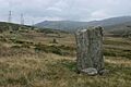
The "Two Stones" that give this pass its name are very old, tall stones called monoliths. Nobody knows exactly when they were placed there, but they mark the highest point of the pass, which is about 427 meters (1,400 feet) high. The larger stone stands about 3 meters (10 feet) tall, while the smaller one is about 2 meters (6.5 feet) high. These stones have stood there for a very long time, watching over the pass.
Ancient Discoveries Along the Path
Near the mountain gate, on the south side of the track, you can also find other ancient sites. There's a stone circle and a cromlech (which is a type of ancient tomb made of large stones) called Maen-y-bardd, or "the bard's stone," closer to Rowen. These show that people have been using and living around this pass for thousands of years.
Why was Bwlch-y-Ddeufaen an Important Route?
For many centuries, the path through Bwlch-y-Ddeufaen was a vital drovers' road. Drovers were people who moved livestock, like cattle, sheep, and even geese, on foot from one place to another for sale. This particular route was part of a big network of drovers' roads that connected farms in Wales to major towns and markets across Wales and England.
Driving Livestock to Market
Animals were regularly driven along this path, sometimes all the way to London, which was the biggest market in Britain. This practice continued until at least the 1850s. Imagine herds of animals walking for days or weeks through these mountains!
Roman Connections to the Pass
The Romans also used this route. Several Roman milestones, which were stone markers showing distances along Roman roads, have been found here. One of these milestones even mentioned the distance to Kanovium (Caerhun), showing how important this road was to the Romans.
A Medieval Castle Site
Near the Abergwyngregyn end of the green path, you can see a green mound. This mound is what's left of a motte-and-bailey castle. This type of castle was built by Llywelyn the Great, a powerful Welsh prince who lived in the 13th century. Castles like this were important for controlling the land and protecting people.
Images for kids
-

The taller (3m) south-east stone
-
The north-west stone (2m)


