Caherconnell Stone Fort facts for kids
|
Cathair Chonaill
|
|

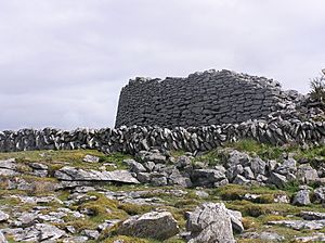
Part of the wall of Caherconnell Stone Fort
|
|
| Location | Parish of Kilcorney, the Burren |
|---|---|
| Region | Ireland |
| Coordinates | 53°02′27″N 9°08′21″W / 53.04075°N 9.139172°W |
| Type | Ringfort |
| History | |
| Periods | Medieval |
| Site notes | |
| Archaeologists | Graham Hull |
| Ownership | private |
| Public access | yes |
Caherconnell (which means 'Conall's stone fort' in Irish) is a really old and well-kept stone fort. It's found in a special area called the Burren in County Clare, Ireland. This fort was built a long, long time ago, during the Medieval period. It's located about 1 kilometer south of the famous Poulnabrone dolmen.
Contents
Where is Caherconnell?
Caherconnell is in County Clare, Ireland. It's found west of the R480 road. This road connects Ballyvaughan and Leamaneh Castle. The area around the fort is called the Burren. The ground here is mostly karst limestone. This means it's a rocky area. Farmers use the land for grazing animals.
What Does Caherconnell Look Like?
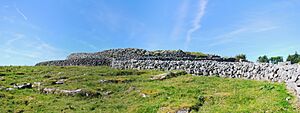
Caherconnell is a circular fort. It has a strong stone wall that goes all the way around it. This wall is about 42 meters across. The walls are very thick, up to 3 meters wide. They are also up to 3 meters tall. There are many loose stones around. This suggests the walls were once even taller, maybe an extra meter. The walls are made from local limestone. The main entrance to the fort faces east.
Inside the fort, you can still see parts of a stone wall. This wall divided the inside space. There are also remains of two buildings. Building A is near the north wall of the fort. It's shaped like a rectangle. It measures about 10 meters long and 5 meters wide. Building B is near the west wall. It's about 7.5 meters long and 5 meters wide. Its north wall is part of the dividing wall.
Other structures are found around the fort. People thought there might be an underground passage, called a souterrain. But no clear proof of one has been found yet. Caherconnell is similar to other old stone forts. These include Cahermore ringfort and Cahermacnaghten. These forts were used for a very long time.
What Have We Learned from Digging?
Archaeologists dug at Caherconnell in 2007. They used Radiocarbon dating to find out how old things were. The fort was mostly built between the early 900s and the mid-1100s. People lived in the fort from about the early 900s to the early 1200s.
Building A, the rectangular one, was built later. It was likely built between the early 1400s and the mid-1600s. We don't know if people lived in the fort all the time. There might have been a time in the 1300s when it was empty.
The things found during the dig tell us a lot. The people living there were important. They used fancy items. They also made things like pins right at the fort. There is evidence of working with valuable metals. They also worked with iron. Archaeologists said the fort's strong walls and large size make it special. It stands out from most other forts in the Burren.
The fort was used for a long time, even into more recent history. This is because the local O'Loghlen family controlled the area. They were not much affected by outside influences. So, the local culture stayed strong for a long time.
The people who lived in the fort in the 1400s and 1500s were not from the main O'Loghlen family. That family had moved to Glensleade Castle. This castle was about 3 kilometers north of Caherconnell.
Archaeologists also found traces of an even older building. It was a wooden structure. It might be from the Neolithic or Bronze Age. This was found southwest of the fort. It's very unusual for Ireland and Britain. Experts are still studying it. It might have been a kiln for drying corn in medieval times. But a mystery remains. Partial remains of three people were found near its entrance. These remains are from the 1400s or 1500s.
Caherconnell Today
You can visit Caherconnell today! The owner has a visitor center. It has a video presentation about the fort. There is also a café where you can get a snack.
Since 2010, Caherconnell has also been a place for students to learn. It hosts an archaeological field school. Students can learn how to dig and study old sites. They learn from top archaeologists.
See also
 In Spanish: Caherconnell para niños
 | Kyle Baker |
 | Joseph Yoakum |
 | Laura Wheeler Waring |
 | Henry Ossawa Tanner |


