
Caibarién facts for kids
Quick facts for kids
Caibarién
|
||
|---|---|---|

The Glorieta of Caibarién
|
||
|
||
| Nickname(s):
La Villa Blanca (The White Town)
|
||
.png)
Caibarién municipality (red) within
Villa Clara Province (yellow) and Cuba |
||
| Country | Cuba | |
| Province | Villa Clara | |
| Founded | 1832 | |
| Established | 1873 (Village) | |
| Municipality | 1879 | |
| Area | ||
| • Total | 212 km2 (82 sq mi) | |
| Elevation | 5 m (16 ft) | |
| Population
(2022)
|
||
| • Total | 40,798 | |
| • Density | 192.4/km2 (498.4/sq mi) | |
| Time zone | UTC-5 (EST) | |
| Area code(s) | +53-42 | |

Caibarién is a city and a municipality in the Villa Clara province of Cuba. It is often called "La Villa Blanca," which means "The White Town." This nickname comes from its beautiful sandy beaches.
Caibarién is also famous for its "Parrandas," which are big carnivals. These celebrations are shared with nearby towns like Remedios, which is about 7 kilometers (4.3 miles) away, and Camajuani.
Contents
History of Caibarién
Early Explorers and Settlements
Around the end of 1513, explorers like Pánfilo de Narváez explored this area. They found groups of native people living here. These settlements were in the region where Caibarién is today. They also lived on a small island called Cayo Conuco.
Founding the Town
In 1819, a port called Tesisco was closed. Because of this, the port of Caibarién was opened. Starting in 1822, people from Remedios began to move here. A small community grew in the area known as Parrado. Narciso de Justa, a local landowner, gave some of his land to help start the town.
On October 26, 1832, Caibarién was officially founded. It was planned with 42 blocks, each having 10 lots. Most of these lots were sold. The rest were set aside for government buildings.
Becoming a Village and Municipality
On August 31, 1873, Caibarién was given the title of "Villa" (village). Then, on January 1, 1879, the town council was formed. Don Hipólito Escobar Martelo became its first mayor.
Before the war in 1895, the town grew steadily. It became very strong economically, which was quite amazing for that time.
Growth in the 20th Century
The early 1900s saw the biggest growth in Caibarién's city area. As more people moved in, many important public and private buildings were built. These included places for culture, education, and industry.
Later, things changed. The building of a main highway and the port of Cienfuegos affected Caibarién. Also, the Tarafa railroad was built. These changes, along with political issues, meant the town's economy didn't grow as much until 1959.
After 1959, a new period began. New neighborhoods and buildings were constructed. Industries and businesses also grew, improving life for the people.
In recent times, the municipality has faced economic challenges. This has led to some changes in the town's buildings and population.
Geography of Caibarién
Location and Surroundings
Caibarién is located on the north coast of Cuba. It sits next to the Bay of Buena Vista, which is part of the Atlantic Ocean. The city is at the eastern edge of the Villa Clara Province. It is also close to the border of the Sancti Spíritus Province. Caibarién has its own airport, called Caibarién Airport (MUCB).
The municipality is divided into several areas. These are called Primero, Segundo, Tercero, Cuarto, and Quinto.
Cayo Conuco Island
Cayo Conuco is a small island about 7 kilometers (4.3 miles) off the coast of Caibarién. A stone causeway connects it to the mainland. This island was once mostly dry grassland. Now, native plants are growing back. In 1948, the Asociación de Scouts de Cuba held their second national Jamboree here.
Economy and Tourism
Caibarién used to be an important place for shipping farm products. These included sugarcane, tobacco, and fruit. It was also a center for sponge fishing.
Today, some of the older buildings and piers are no longer in use. The two sugar mills that once sent their sugar through the harbor are now closed. One of the main sugar mills, Reforma, is now a museum for visitors.
Parrandas Carnivals
The famous Parrandas carnivals happen twice a year. They usually take place in August–September and again in mid-December. Each carnival lasts for about two weeks.
The Cayos for Tourists
A major attraction for tourists in Caibarién is "Los Cayos" (The keys). These are small islands like Cayo Santa María, Cayo Fragoso, and Cayo Las Brujas. These islands have beautiful resorts. Recently, new rules in Cuba allow Cuban citizens to visit these resorts and beaches, which were once only for tourists.
Population Information
In 2022, the municipality of Caibarién had a population of 40,798 people. The total area of the municipality is about 212 square kilometers (82 square miles). This means there are about 179.5 people living in each square kilometer (465 people per square mile).
Sister Cities
Caibarién has a sister city relationship with:
Notable people
Gallery
-
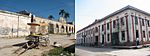
Less than a century ago one of the biggest and busiest port cities in Cuba, but today the still standing colonial storehouses are empty and collapsing owing to lack of restoration and use.
-
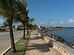
The newly made sea walk. Tourism in the northern cays of Caibarién's waters have infused a little money for public works in the city, still; most of the historic buildings are left aside until they collapse.
-
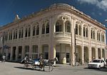
Former lyceum today holds shops and Caibarién's local history museum.


See also
 In Spanish: Caibarién para niños
